


Click Image to Enlarge
Nebraska Counties
There is ninety-three counties in state of Nebraska. Despite the fact that Sarpy County contained the oldest settlement in the state, it was one of the last lands along the river to be recognized by law. Finally, on February 1, 1857, the land "where the cities meet the country" was officially created.Arthur County, Nebraska
Arthur County Education, Geography, and History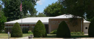
Arthur County is a county located in the state of Nebraska. Based on the 2010 census, the population was 460, making it the least populous county in Nebraska and the fifth-least populous county in the United States (behind only Loving County, Texas, Kalawao County, Hawaii, King County, Texas, and Kenedy County, Texas). Its county seat and only incorporated community is Arthur.
Etymology - Origin of Arthur County Name
Arthur County, named after President Chester A. Arthur, and McPherson County originally came under the jurisdiction of Logan County
Demographics:
County QuickFacts: CensusBureau Quick Facts
Arthur County History
Arthur County is among those areas in
Nebraska that carry the distinction of being land that has been under the flag
of three different countries at one time or another. With the Louisiana Purchase
of 1803, the area finally became part of the United States.
Some historians believe the frontier ended by the 1890s, but Nebraska continued
organizing counties into the early 20th century. In fact, although boundaries
for what today is Arthur County were established in 1887, the county itself was
not formally organized until 1913. The courthouse that was built in 1914 and
served the citizens for the next 48 years gained notoriety for possibly being
the smallest courthouse in the United States. It was replaced by the county's
present courthouse in 1962.
Arthur County, named after President Chester A. Arthur, and McPherson County
originally came under the jurisdiction of Logan County. In late 1889, McPherson
County grew to where it could support its own government and, according to the
laws of that time, what would become Arthur County came under its jurisdiction.
With the Kinkaid Act of 1904, the area began to be settled at a more rapid pace.
The increase in the number of residents and in tax revenues quickly put schools
and local government on a more solid financial foundation. This southern
Sandhills region grew from 517 inhabitants in 1900 to nearly 2,500 by 1910.
It became clear to the inhabitants of the area that separate counties and
separate county seats were needed. A letter appearing in the March 13, 1913
edition of the Hustler, Arthur County's first legal publication, noted "For the
number of people and to dispense justice and liberty, would it not be best to
make two counties and let Arthur County come back on the map!"
State lawmakers were in agreement and during the 1912-1913 session of the
Legislature passed a second enabling act authorizing Arthur County to proceed
with its organization.
Geography: Land and Water
As reported by the Census Bureau, the county has a total area of 718 square miles (1,860 km2), of which 715 square miles (1,850 km2) is
land and 3.0 square miles (7.8 km2) (0.4%) is water
Neighboring Counties
Bordering counties are as follows:
- Grant County, Nebraska - north
- Hooker County, Nebraska - northeast
- McPherson County, Nebraska - east
- Keith County, Nebraska - south
- Garden County, Nebraska - west
Education


Click Image to Enlarge
