


Click Image to Enlarge
Nebraska Counties
There is ninety-three counties in state of Nebraska. Despite the fact that Sarpy County contained the oldest settlement in the state, it was one of the last lands along the river to be recognized by law. Finally, on February 1, 1857, the land "where the cities meet the country" was officially created.Cass County, Nebraska
Cass County Education, Geography, and History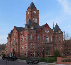
Cass County is a county located in the state of Nebraska. Based on the 2010 census, the population was 25,241. Its county seat is
Plattsmouth. The county was formed in 1855 and named after General Lewis Cass.
Cass County is included in the Omaha-Council Bluffs, NE-IA Metropolitan Statistical Area
Etymology - Origin of Cass County Name
The county was named in honor of Gen. Lewis Cass, an American statesman and patriot.
Demographics:
County QuickFacts: CensusBureau Quick Facts
Cass County History
Long before Cass County was
organized, the rolling hills and lush valleys of this area were inhabited by
Native Americans. Abundant water from both the Missouri and Platte Rivers and a
wealth of fresh game made this area popular with both the Pawnee and Otoe
tribes. Early history records indicate that this popularity also led to
conflicts. In fact, one of the West's largest battles ever fought between Indian
tribes is said to have occurred between the Omahas and the Otoes along the banks
of Weeping Water Creek.
Early explorations of the area have been traced back to those of the French in
the 1730s. Following a series of explorations in the early 1800s, trappers began
to frequent the area in the 1820s and 1830s. Sometime around 1848 a Mormon named
Libeas Coon established a ferry across the Missouri River for the convenience of
the Mormons who were moving west. This resulted in a trail along the south side
of the Platte River, but no permanent settlements.
The first federal government permit to settle in the area was issued to Samuel
Martin, who in 1853 built a log house and trading post known as the "Old
Barracks" near the confluence of the Platte and Missouri Rivers. In addition to
trading furs with the Native Americans, Martin operated a ferry between
Glenwood, Iowa, and Platteview, now known as Plattsmouth.
When the boundaries were officially adopted by the Legislature in 1855, the
county was named in honor of Gen. Lewis Cass, an American statesman and patriot.
In that same legislative act, Plattsmouth was designated as the county seat. The
county's boundaries were redefined to their present dimensions the following
year.
Despite three petition and special election attempts to move the county seat,
the last coming in 1880, the courthouse has always remained in Plattsmouth. The
original frame building was used until it was outgrown in 1891, at which time
bonds were approved and the present courthouse was constructed.
Geography: Land and Water
As reported by the Census Bureau, the county has a total area of 566 square miles (1,470 km2), of which 557 square miles (1,440 km2) is
land and 8.4 square miles (22 km2) (1.5%) is water.
Neighboring Counties
Bordering counties are as follows:
- Sarpy County, Nebraska - north
- Mills County, Iowa - northeast
- Fremont County, Iowa - southeast
- Otoe County, Nebraska - south
- Lancaster County, Nebraska - west
- Saunders County, Nebraska - northwest
Education


Click Image to Enlarge
