


Click Image to Enlarge
Nebraska Counties
There is ninety-three counties in state of Nebraska. Despite the fact that Sarpy County contained the oldest settlement in the state, it was one of the last lands along the river to be recognized by law. Finally, on February 1, 1857, the land "where the cities meet the country" was officially created.Cherry County, Nebraska
Cherry County Education, Geography, and History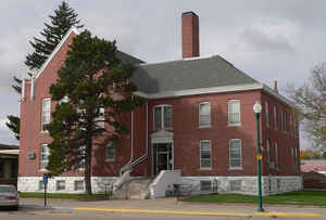
Cherry County is a county located in the state of Nebraska. Based on the 2010 census, the population was 5,713. Its county seat is Valentine. The county was named for Lt. Samuel A. Cherry, an Army officer who was stationed at Fort Niobrara and who had been killed in South Dakota in 1881. Cherry County is located in the Nebraska Sandhills.
Etymology - Origin of Cherry County Name
t was named in honor of US Fifth Cavalry Lt. Samuel A. Cherry, who had been murdered north of Fort Niobrara two years earlier.
Demographics:
County QuickFacts: CensusBureau Quick Facts
Cherry County History
There are many attributes which make
Cherry County unique, not only among the counties in Nebraska, but also among
the nation's counties.
First, of course, is the county's size. With 6,048 square miles, Cherry County
is by far the largest in total land area of all Nebraska counties and ranks as
one of the country's largest. And because of its 96-mile-by-63-mile dimensions,
it is the only Nebraska county dissected by two time zones.
Also unique to Cherry County are the natural waterfalls located along the rivers
that traverse the area. Snake River Falls ranks as the largest in Nebraska,
while Smith Falls is said to be the tallest. Also located here is the well-known
Shlegal Creek Falls.
Finally, the county seat of Valentine makes the news reports each February 14
when literally thousands of cards and letters from across the United States are
received by the local post office, which in turn places a special Valentine
stamp on each before re-mailing them to the addressee.
The first settlement in this area can be traced to 1878 when the government
located about 5,000 Sioux Indians on the Rosebud Reservation, which borders
Cherry County on the north in South Dakota. The government agreed to provide
beef for the reservation and, as a result, large herds of cattle were brought
into this northern Sandhills area for grazing in the expansive open range and
along the Niobrara River. Also, Fort Niobrara was established along the river,
about four miles east of the present day Valentine, to provide protection for
the settlers and cowboys.
Cherry County's boundaries were established by the Legislature in 1883. It was
named in honor of US Fifth Cavalry Lt. Samuel A. Cherry, who had been murdered
north of Fort Niobrara two years earlier.
The county's first courthouse was an abandoned military building brought into
Valentine from Wisconsin. In 1901 a new $15,000 courthouse replaced it. The
present courthouse was constructed in 1954.
Today, this Sandhills county is often referred to the "Heart of Cattle Country,"
"Home of a Million Cattle," and "God's Own Cow Country."
Geography: Land and Water
As reported by the Census Bureau, the county has a total area of 6,009 square miles (15,560 km2), of which 5,960 square miles (15,400
km2) is land and 49 square miles (130 km2) (0.8%) is water. It is by far the largest county in land area in Nebraska and larger than the state
of Connecticut, or the states of Delaware and Rhode Island combined. The county is within the Sandhills region of Nebraska; the dunes that
give the region its name are a result of the most recent glacial period, known as the Pinedale glaciation. During the Holocene glacial retreat
the sand dunes, which had been deposited in their current location by the vast continental glaciers, were exposed and grasses eventually took
over.
Cherry County is also the location of the Valentine National Wildlife Refuge, the Fort Niobrara National Wildlife Refuge, the Samuel R.
McKelvie National Forest, and the western portion of the Niobrara National Scenic River.
Neighboring Counties
Bordering counties are as follows:
- Bennett County, South Dakota - north
- Todd County, South Dakota - north
- Tripp County, South Dakota - northeast
- Brown County, Nebraska - east
- Keya Paha County, Nebraska - east
- Blaine County, Nebraska - southeast
- Grant County, Nebraska - south
- Thomas County, Nebraska - south
- Hooker County, Nebraska - south
- Sheridan County, Nebraska - west
- Oglala Lakota County, South Dakota - northwest
Education


Click Image to Enlarge
