


Click Image to Enlarge
Nebraska Counties
There is ninety-three counties in state of Nebraska. Despite the fact that Sarpy County contained the oldest settlement in the state, it was one of the last lands along the river to be recognized by law. Finally, on February 1, 1857, the land "where the cities meet the country" was officially created.Cuming County, Nebraska
Cuming County Education, Geography, and History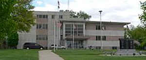
Cuming County is a county located in the state of Nebraska. Based on the 2010 census, the population was 9,139. Its county seat is West Point.
Etymology - Origin of Cuming County Name
Named after acting Territory Gov. Thomas B. Cuming.
Demographics:
County QuickFacts: CensusBureau Quick Facts
Cuming County History
For three years after the original
boundaries of Cuming County were defined in 1855, fictitious "paper" towns were
designated as the county seat. The first was "Catherine," along the Elkhorn
River. When the boundaries were redefined in 1857, the county seat was relocated
to "Manhattan."
County organization came the following year and the county was named after
acting Territory Gov. Thomas B. Cuming. The seat of local government was once
again moved. This time it was to an actual settlement that had been known as New
Philadelphia, which by then had been renamed West Point. It was named as such
because it was located at the western-most point of where the Elkhorn River
Valley was settled at the time.
The first officials to serve the county did so without pay for nearly five
years. During that time period they also paid for necessary county supplies out
of their own pockets.
In the early 1860s the area developed rapidly. J.D. Neligh, founder of West
Point, journeyed to Omaha and Fontanelle to encourage settlers to come to the
lush river valley. Seven families accepted his suggestion and, upon arriving in
the area, called it the "Garden of the West."
As stores, hotels and a grist mill were built in West Point, the next move was
to build a courthouse in 1870. The building, complete with a tower, would stand
as a Northeast Nebraska landmark for many years.
The courthouse that serves the county today is a result of the foresight of
residents and officials of the 1940s. Petitions were circulated and presented to
the Board of Supervisors on May 6, 1947, asking that an election be held to
approve a one-mill tax levy for five years to provide a building fund for a new
courthouse. The election was held the following June and was resoundingly
approved by a 3-to-1 margin.
Ground was broken on Sept. 1, 1953, immediately behind the old courthouse.
Construction progressed so rapidly that the old courthouse was vacated and razed
the following year. In December 1854, county offices moved into the new
courthouse, which was dedicated July 21, 1955.
Geography: Land and Water
As reported by the Census Bureau, the county has a total area of 575 square miles (1,490 km2), of which 571 square miles (1,480 km2) is
land and 4.0 square miles (10 km2) (0.7%) is water
Neighboring Counties
Bordering counties are as follows:
- Thurston County (northeast)
- Burt County (east)
- Dodge County (south)
- Colfax County (southwest)
- Stanton County (west)
- Wayne County (northwest)
Education


Click Image to Enlarge
