


Click Image to Enlarge
Nebraska Counties
There is ninety-three counties in state of Nebraska. Despite the fact that Sarpy County contained the oldest settlement in the state, it was one of the last lands along the river to be recognized by law. Finally, on February 1, 1857, the land "where the cities meet the country" was officially created.Dawes County, Nebraska
Dawes County Education, Geography, and History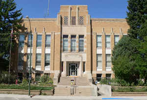
Dawes County is a county located in the state of Nebraska. Based on the 2010 census, the population was 9,182. Its county seat is Chadron. The county was formed in 1885 and named after Governor James W. Dawes.
Etymology - Origin of Dawes County Name
Namedin honor of Gov. James. W. Dawes.
Demographics:
County QuickFacts: CensusBureau Quick Facts
Dawes County History
Dawes County is noted for it
beautiful pine forest ridges and for being home to the historic Fort Robinson,
the "Outpost of the Plains" that was established by the United States Army in
1874. Today, Fort Robinson is one of Nebraska's most popular tourist and
vacation attractions.
In the 1870s, the area that would become Dawes County was inhabited by two large
divisions of the Sioux tribe. The Brules were located at the Spotted Tail agency
on the White River, while the Ogalalas were at the Red Cloud agency just east of
Fort Robinson. Toward the end of the 1870s and into the 1880s, cattlemen came to
the area to lay out ranches.
Since the lands were unsurveyed and belonged to the public domain, the unwritten
law of the land at the time was the first to establish a ranch on a certain
creek or in a certain locale was entitled to sufficient range for his needs. The
"range" boundaries were well defined and no one encroached upon the rights of
his neighbor. Small ranches would have 500 head of cattle, while others were as
large as 2,000 to 5,000 head. While the unwritten law of the land worked well,
these ranchers had no legal rights to the land.
In 1882, the cattlemen received word that two railroads were going to extend
their lines through the territory and that the government was about to survey
the area with the intent of opening the lands for legal entry and settlement.
With a new era on the horizon, open range ranching began to give way to the
grain farming of the new homesteaders. By 1885, the cowboy era had virtually
come to an end.
Dawes County was officially organized that same year, when it was split from
Sioux County. It was named in honor of Gov. James. W. Dawes. The issue of
locating a county seat was hotly contested between Chadron and Dawes City, which
would become Whitney. Chadron became the seat of local government by a narrow
margin in a special election. Two years later, in 1887, the county's original
courthouse was build for approximately $35,000. The present courthouse was
constructed in 1936.
Geography: Land and Water
As reported by the Census Bureau, the county has a total area of 1,401 square miles (3,630 km2), of which 1,396 square miles (3,620 km2)
is land and 4.6 square miles (12 km2) (0.3%) is water
Neighboring Counties
Bordering counties are as follows:
- Oglala Lakota County, South Dakota - northeast
- Sheridan County, Nebraska - east
- Box Butte County, Nebraska - south
- Sioux County, Nebraska - west
- Fall River County, South Dakota - northwest
Education


Click Image to Enlarge
