


Click Image to Enlarge
Nebraska Counties
There is ninety-three counties in state of Nebraska. Despite the fact that Sarpy County contained the oldest settlement in the state, it was one of the last lands along the river to be recognized by law. Finally, on February 1, 1857, the land "where the cities meet the country" was officially created.Deuel County, Nebraska
Deuel County Education, Geography, and History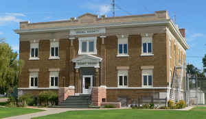
Deuel County is a county located in the state of Nebraska. Based on the 2010 census, the population was 1,941. Its county seat is Chappell. The county was formed in 1889 and named after Harry Porter Deuel, superintendent of the Union Pacific Railroad.
Etymology - Origin of Deuel County Name
Deuel County, named after a Union Pacific Railroad official
Demographics:
County QuickFacts: CensusBureau Quick Facts
Deuel County History
The area of Deuel County was once a
popular hunting ground for the Ogalala and Brule tribes of the Teton Sioux
Indian nation. An influx of trappers, pioneers and settlers led to growing
tensions and frequent battles.
Deuel County, named after a Union Pacific Railroad official, was once the
eastern third of Cheyenne County. It was split in 1888 and officially organized
the following year. At the time, Deuel County also included the area that is
today Garden County. In 1909 an election was held and Garden County was formed
from the northern three-fourths of Deuel County.
The county seat of Chappell possesses an interesting history. Charles Henry
Chappell, an Illinois railroad man, was responsible for construction in the
western division. When lumber, rails and supplies were shipped from Omaha to the
end of the route, the instructions would simply read, "Send this to Chappell."
The siding became known as Chappell.
Becoming the county seat was not an easy task. When the county was organized, a
three-way fight involving Big Springs, Chappell and Froid developed. A special
election was held in February 1889. Chappell precinct had 275 legal voters,
while Big Springs had 200 legal voters. When the election was completed,
Chappell precinct reported a 3,210 to seven victory. Big Springs claimed it had
won by a 5,616 to 87 vote. The honesty of Froid was demonstrated when it show a
tally of just 292 votes.
Charges of illegal voting were made by both Chappell and Big Springs. A judge
ordered county offices to remain in Chappell. It would not be until April 1894
that Judge Silas A. Holcombe rendered a decision. Since the ballots and election
records had been stolen, the court could not make a determination as to the
victor and ordered a new election. It took two elections that year before a
majority vote was cast and Chappell was the winner.
The present courthouse was constructed in 1915 and is located on the same site
as the first small structure that was used during the county's stormy
organizational days.
Geography: Land and Water
As reported by the Census Bureau, the county has a total area of 411 square miles (1,060 km2), of which 440 square miles (1,100 km2) is
land and 0.9 square miles (2.3 km2) (0.2%) is water.
Neighboring Counties
Bordering counties are as follows:
- Garden County - north
- Keith County - east
- Perkins County - southeast
- Sedgwick County, Colorado - south
- Cheyenne County - west
Education


Click Image to Enlarge
