


Click Image to Enlarge
Nebraska Counties
There is ninety-three counties in state of Nebraska. Despite the fact that Sarpy County contained the oldest settlement in the state, it was one of the last lands along the river to be recognized by law. Finally, on February 1, 1857, the land "where the cities meet the country" was officially created.Dodge County, Nebraska
Dodge County Education, Geography, and History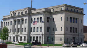
Dodge County is a county located in the state of Nebraska. Based on the 2010 census, the population was 36,691. Its county seat is
Fremont. The county was formed in 1855 and named after the US Senator Augustus Caesar Dodge.
Dodge County comprises the Fremont, NE Micropolitan Statistical Area, which is also included in the Omaha-Council Bluffs-Fremont, NE-IA
Combined Statistical Area.
Etymology - Origin of Dodge County Name
Namedin honor of Augustus Caesar Dodge, a United States senator from Iowa who was a supporter of the Kansas-Nebraska Act.
Demographics:
County QuickFacts: CensusBureau Quick Facts
Dodge County History
Dodge County was organized and it
boundaries defined by an act of the First Territorial Legislature in March 1855.
These boundaries would be redefined again in November 1858 and December 1859,
and county would be reorganized for the final time in January 1860. It is named
in honor of Augustus Caesar Dodge, a United States senator from Iowa who was a
supporter of the Kansas-Nebraska Act.
With Dodge County being bordered on the east by the Elkhorn River and on the
south by the Platte River, trappers and hunters made up the earliest
inhabitants. The earliest settlements were recorded in 1856 along the Platte
River in locations that would eventually become the cities of Fremont and North
Bend. Because the Mormon Trail, which paralleled the Platte River, and the Old
Military Road, which connected Omaha with Fort Kearny, passed through the area,
freighting became an important part of the county's development. Since settlers
grew only enough crops for their own use, it would be a number of years before
agriculture would become a prominent part of the area.
In 1860, three towns vied to become the county seat. Fremont received 62 votes,
Robinsonville received two votes and Blacksmith's Point received one vote. The
latter two would cease to exist shortly thereafter. For seven years after
Fremont had been chosen to serve as the county seat, county offices and records
were maintained in the homes of different officers and in leased apartments.
Although the question of building a courthouse had been discussed many times, a
consensus could not be reached. A wealthy Fremont landowner donated a city block
for the purpose of being used for a courthouse. Original plans drawn for a
wooden structure were eventually abandoned in favor of a brick building.
Finally, in late 1867, the building was completed.
The brick structure was remodeled and repaired three times before a second
courthouse opened in October 1890. A 1915 fire destroyed that structure and
three years later the present courthouse was dedicated.
Geography: Land and Water
As reported by the Census Bureau, the county has a total area of 543 square miles (1,410 km2), of which 529 square miles (1,370 km2) is
land and 14 square miles (36 km2) (2.6%) is water
Neighboring Counties
Bordering counties are as follows:
- Burt County (northeast)
- Washington County (east)
- Douglas County (southeast)
- Saunders County (south)
- Colfax County (west)
- Cuming County (north)
Education


Click Image to Enlarge
