


Click Image to Enlarge
Nebraska Counties
There is ninety-three counties in state of Nebraska. Despite the fact that Sarpy County contained the oldest settlement in the state, it was one of the last lands along the river to be recognized by law. Finally, on February 1, 1857, the land "where the cities meet the country" was officially created.Douglas County, Nebraska
Douglas County Education, Geography, and History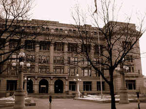
Douglas County is a county located in the state of Nebraska. Based on the 2010 census, the population was 517,110. It is the state's most populous county, home to over one-fourth of Nebraska's residents. Its county seat is Omaha, the state's largest city. The county was established in 1854 and named after Stephen A. Douglas (1813-1861), US Senator from Illinois.
Douglas County is included in the Omaha-Council Bluffs, NE-IA Metropolitan Statistical Area.
Etymology - Origin of Douglas County Name
Namedin honor of Illinois Sen. Stephen A. Douglas
Demographics:
County QuickFacts: CensusBureau Quick Facts
Douglas County History
Douglas County is one of the eight
counties that made up the original Nebraska Territory. In June 1854, President
Franklin Pierce announced the ratification of a treaty made with the Omaha
Indians which ceded the land along the Missouri River to the government for
settlement. It was the responsibility of acting Gov. Thomas B. Cuming to divide
the land into counties based on census figures.
The fact that Douglas County, which was named in honor of Illinois Sen. Stephen
A. Douglas, was located in the geographic center of the eight counties played an
important role in its development. When a census of the eight-county region was
completed in November 1854, it showed the territory had a population of 2,732.
Gov. Cuming then issued a proclamation ordering an election for members of the
Territorial Legislature. Once its members were elected, the body convened for
the first time on Jan. 15, 1855, in Omaha.
When it came time to locate the territorial capital, Omaha was a logical
selection due to its central location. It would remain the capital until
Nebraska was admitted to the Union in 1867, at which time it was moved to the
present city of Lincoln.
Even though the capital was relocated to Lincoln, Omaha and Douglas County would
enjoy tremendous prosperity in the 1860s and 1870s. It began in 1863 when ground
was broken at Omaha for the Union Pacific Railroad. Rapid development followed
and within six years Omaha would be designated as a city of the first class.
Douglas County has had three courthouses since its boundaries were established.
The first dates back to 1858 when a two-story structure was built in downtown
Omaha. Soon the county outgrew the building and plans were made for a
replacement. In 1882 a new courthouse was unveiled. Within 25 years the county
had once again outgrown its courthouse. Between 1910 and 1912 the county's third
courthouse was built. Along with the Civic Center, this building still serves
the county today.
Geography: Land and Water
As reported by the Census Bureau, the county has a total area of 339 square miles (880 km2), of which 328 square miles (850 km2) is land
and 11 square miles (28 km2) (3.2%) is water
Neighboring Counties
Bordering counties are as follows:
- Dodge County (northwest)
- Washington County (north)
- Pottawattamie County, Iowa (east)
- Sarpy County (south)
- Saunders County (west)
Education


Click Image to Enlarge
