


Click Image to Enlarge
Nebraska Counties
There is ninety-three counties in state of Nebraska. Despite the fact that Sarpy County contained the oldest settlement in the state, it was one of the last lands along the river to be recognized by law. Finally, on February 1, 1857, the land "where the cities meet the country" was officially created.Otoe County, Nebraska
Otoe County Education, Geography, and History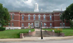
Otoe County is a county located in the state of Nebraska. Based on the 2010 census, the population was 15,740. Its county seat is Nebraska City. The county was formed in 1854 and named after the Otoe Indian tribe.
Etymology - Origin of Otoe County Name
The county was named after the Watota Indians, one of the many tribes which lived along the Missouri River. Otoe is derived from Oto, the Indian abbreviation of Watota, which means "lovers of pleasure."
Demographics:
County QuickFacts: CensusBureau Quick Facts
Otoe County History
Two years before the Nebraska
Territory would be granted statehood in 1867, William R. Craig and F.W. Wood
completed a grand two-story brick building that 129 years later holds the honor
of being the oldest public building in Nebraska. That building is the Otoe
County Courthouse.
Otoe County was defined by the Territorial Legislature on March 2, 1855, the
same year that Nebraska City was platted. The county was named after the Watota
Indians, one of the many tribes which lived along the Missouri River. Otoe is
derived from Oto, the Indian abbreviation of Watota, which means "lovers of
pleasure."
When the county was created, Nebraska City was designated as the county seat.
For several years there were no official county offices. Rather, county business
would be conducted from a log cabin and from rooms that were rented from
Nebraska City stores.
Whether it was by design or by chance, when the courthouse was built in 1865 it
was built on ground that was once part of an Indian cemetery. When it was
completed, the courthouse cost $22,500. County offices were located on the
build's first floor, the District Court on the second floor, and the jail in the
basement.
The first addition to the courthouse was made in 1882 with a wing added to the
west end. In 1936 it became apparent that additional space was once again needed
and an identical two-story wing was added to the east side of the original
courthouse. Ironically, the second addition cost nearly three times what the
original courthouse cost 71 years earlier.
Today, the Otoe County Courthouse is among those listed on the National Register
of Historic Places.
Also rich in the history of Otoe County is J. Sterling Morton, who served as
Secretary of the Nebraska Territory and twice as its acting governor. In
addition, Morton was Secretary of Agriculture in President Grover Cleveland's
administration. Despite this public service, Morton is best known as the
originator of Arbor Day
Geography: Land and Water
As reported by the Census Bureau, the county has a total area of 619 square miles (1,600 km2), of which 616 square miles (1,600 km2) is
land and 3.4 square miles (8.8 km2) (0.5%) is water.
The eastern boundary of this county is the Missouri River. It is a largely agricultural region with rolling hills and rich soil. Corn,
soybeans, milo (grain sorghum), wheat, and other, less common, grain crops are joined by several commercial apple orchards. Animal husbandry
concentrates on beef cattle, the locally produced grains being excellent sources of feed for them. Otoe County derives its name from the Otoe
Indians. The Otoe lived along the Missouri River in the area that is now Otoe County
Neighboring Counties
Bordering counties are as follows:
- Cass County - north
- Fremont County, Iowa - east
- Atchison County, Missouri - southeast
- Nemaha County - south
- Johnson County - south
- Gage County - southwest corner
- Lancaster County - west
Education


Click Image to Enlarge
