


Click Image to Enlarge
Nebraska Counties
There is ninety-three counties in state of Nebraska. Despite the fact that Sarpy County contained the oldest settlement in the state, it was one of the last lands along the river to be recognized by law. Finally, on February 1, 1857, the land "where the cities meet the country" was officially created.Richardson County, Nebraska
Richardson County Education, Geography, and History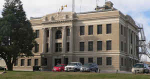
Richardson County is a county located in the state of Nebraska. Based on the 2010 census, the population was 8,363. Its county seat is Falls City
Etymology - Origin of Richardson County Name
Richardson County was among the eight original counties to comprise the Nebraska Territory in 1854. Located along the Missouri River in the far southeast corner of the state, the county was officially organized the following year by the Territorial Legislature and named after William A. Richardson of Illinois, who would serve as Nebraska's fourth territorial governor in 1858.
Demographics:
County QuickFacts: CensusBureau Quick Facts
Richardson County History
In the early years the area of
Richardson County included what is today Pawnee County. But public sentiment in
the western part of the county began to develop about creating a separate unit
of government, primarily because most the of county offices were held by men
living in the eastern part of the county. In 1856 the area was divided into two
counties.
Embedded deep in the history of Richardson County is the famous John Brown's
Underground Railroad, a secret network of cooperation which aided slaves in
reaching sanctuary in the free states and Canada. Several of the network's
stations were set up in this area. Ann Dorrington was one of the area's
residents who befriended those fleeing slavery. Her kindness and compassion led
to her being known as "Mother" Dorrington.
Falls City would officially become the county seat in 1871, a full 16 years
after the county was organized. This brought to an end a hotly-contested
campaign that Falls City and Salem were embroiled in for more than a decade.
In 1872 a proposal to issue $25,000 in bonds to build a stone and brick
courthouse did not meet with the approval of the county's voters. The following
year the proposal was scaled back to $15,000 and this time it was successful.
The courthouse that was built would stand until May 1919, when it was destroyed
by fire.
The following July an election was held to levy five mills on the county's
valuation for the purpose of building a new courthouse. Although voters approved
the levy, construction on the present courthouse did not begin until 1924.
Geography: Land and Water
As reported by the Census Bureau, the county has a total area of 555 square miles (1,440 km2), of which 552 square miles (1,430 km2) is
land and 2.7 square miles (7.0 km2) (0.5%) is water.
The lowest point in the state of Nebraska is located on the Missouri River in Richardson County, where it flows out of Nebraska and into
Kansas and Missouri. Richardson County is covered with rolling hills and farm land.
A portion of the county, northeast of Rulo, extends beyond the Missouri River, which is otherwise its border with the state of Missouri.
Neighboring Counties
Bordering counties are as follows:
- Nemaha County - north
- Holt County, Missouri - east
- Doniphan County, Kansas - southeast
- Brown County, Kansas - south
- Nemaha County, Kansas - southwest
- Pawnee County - west
Education


Click Image to Enlarge
