


Click Image to Enlarge
North Carolina Counties
North Carolina is divided into one hundred counties. The establishment of North Carolina counties stretches over 240 years, beginning in 1668 with the creation of Albemarle County and ending with the 1911 creation of Avery and Hoke counties. Five counties have been divided or abolished altogether, the last being Dobbs County in 1791.Jackson County, North Carolina
Jackson County Education, Geography, and History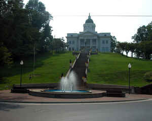
Jackson County is a county located in the southwest of the state of North Carolina. Based on the 2010 census, the population was 40,271.
Since 1913 its county seat has been Sylva, replacing Webster.
Jackson County comprises the Cullowhee, NC Micropolitan Statistical Area.
Etymology - Origin of Jackson County Name
It was named in honor of Andrew Jackson, who won an overwhelming victory from the British at New Orleans in 1815 and who was twice President of the United States.
Demographics:
County QuickFacts: CensusBureau Quick Facts
Jackson County History
Jackson was formed in 1851 from Haywood and Macon. It was named in honor of Andrew Jackson, who won an overwhelming victory from the British at New Orleans in 1815 and who was twice President of the United States. It is in the western section of the State and is bounded by the states of South Carolina and Georgia and Macon, Swain, Haywood and Transylvania counties. The present land area is 490.71 square miles and the 2000 population was 33,121. The first court was ordered to be held at the home of Daniel Bryson, Sr., and after that session the courts were held at Allen Fisher's store until the courthouse was erected. In 1852 an act was passed authorizing an election to be held to decide on moving the county seat from Webster to Sylva. The election was held May 8,1913, and was carried by a majority of 675. Sylva furnished the site and $10,000 in cash for the new courthouse. Sylva is the county seat.
Geography: Land and Water
As reported by the Census Bureau, the county has a total area of 495 square miles (1,280 km2), of which 491 square miles (1,270 km2) is land and 3.8 square miles (9.8 km2) (0.8%) is water.
Neighboring Counties
Bordering counties are as follows:
- Haywood County - northeast
- Transylvania County - east
- Oconee County, South Carolina - south
- Macon County - west
- Swain County - northwest
Education


Click Image to Enlarge
