


Click Image to Enlarge
Oregon Counties
There are thyirty-six counties in the state of Oregon. The Oregon Constitution does not explicitly provide for county seats.Polk County, Oregon
Polk County Education, Geography, and History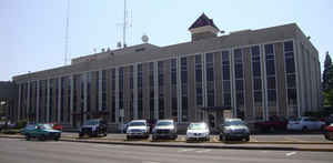
Polk County is a county located in the state of Oregon. Based on the 2010 census, the population was 75,403. The county seat is Dallas.
The county is named for James Knox Polk, the 11th president of the United States.
Polk County is part of the Salem, OR Metropolitan Statistical Area, which is also included in the Portland-Vancouver-Salem, OR-WA Combined
Statistical Area. It is located in the Willamette Valley.
Etymology - Origin of Polk County Name
The county was named after President James Knox Polk and originally included the entire southwestern portion of present day Oregon to the California border.
Demographics:
County QuickFacts: CensusBureau Quick Facts
Polk County History
The Provisional Legislature created
Polk County from Yamhill District on December 22, 1845. The county was named
after President James Knox Polk and originally included the entire southwestern
portion of present day Oregon to the California border. County boundaries were
periodically changed to reflect the creation of Benton and Lincoln Counties.
Polk County today contains 745 square miles and stretches from the Willamette
River on the east to the Coast Range on the west. It is bordered by Yamhill,
Lincoln, Benton, and Marion Counties.
The first county seat was a settlement on the north side of Rickreall Creek
named Cynthian (also known as Cynthia Ann). In 1852 city officials changed the
name to Dallas after Vice President George M. Dallas. By 1856, the lack of an
adequate source of drinking water compelled the town to move more than a mile to
the south. During the 1880s and 1890s, Dallas withstood efforts to move the
county seat to nearby Independence.
Three courthouses have served Polk County. The first was built in Cynthian in
1851 but was dismantled when the town was moved. Soon thereafter the county
built a second courthouse in Dallas, but it was destroyed by fire in 1898.
Construction of the present courthouse began the same year and was completed in
1900. In 1966 the county completed a three-story annex. Further expansion
occurred in 1989 when the Polk County Human Services Department was consolidated
in the newly acquired Academy Building.
For over a century, Polk County was governed by a county court. By the early
1960s the county court had ceased to exercise judicial power and was renamed the
board of commissioners. The board of commissioners acts as the governing body
for the county and is responsible for county administration, management, and
policy.
Polk County's 2000 population of 62,380 represented an increase of 25.92% over
1990.
The major industries of the county are agriculture, forest products,
manufacturing, and education. Western Oregon University is located in Monmouth.
Geography: Land and Water
As reported by the Census Bureau, the county has a total area of 744 square miles (1,930 km2), of which 741 square miles (1,920 km2) is
land and 3.1 square miles (8.0 km2) (0.4%) is water.
About two thirds of Polk County, the western part, is forest, mostly of the coniferous and mixed varieties, bordering on temperate rain forest
around Laurel Mountain, the wettest place in Oregon.
The eastern half of the county lies in the Willamette Valley. The Willamette River forms the eastern border of the county, separating it from
neighboring Marion County.
Neighboring Counties
Bordering counties are as follows:
- Yamhill County (north)
- Marion County (east)
- Benton County (south)
- Lincoln County (west)
- Tillamook County (northwest)
- Linn County (southeast)
Education


Click Image to Enlarge
