


Oregon State Almanac: Facts and Figures
Quick Facts, Figures, and Overview of the State of Oregon
Oregon is one of the Pacific states of the US. Oregon is usually split into eight areas. These are Oregon coast, Rogue Valley, Willamette Valley, Cascade mountains, Columbia River Plateau, Klamath Mountains, Blue Mountains, and Oregon Outback. The western part of Oregon is mountainous and home to Mount Hood and other prominent mountain peaks in the US Oregon is bordered on its west by the Pacific Ocean, north by Washington, south California, east Idaho, and southeast Nevada. The Columbia River delineates much of Oregon's northern boundary, the Snake River largely its eastern. Historians say Oregon was most likely named after one of two rivers. The Columbia River, which forms a coastline along the northern border, was at one time called the Oregon or Ouragan, which is French for hurricane. Others believe the name was derived from a mapmaker's error in the 1700s. The Wisconsin River was named the Ouisconsink and was picked up by travelers referring to the country west of the Great Lakes as Ourigan.
In the agricultural sector, greenhouse and nursery products such as daffodils, gladioli, irises, lilies, peonies and tulips for bulbs are Oregon's most valuable. Hay is Oregon's second ranked crop generating 7% of the state's total agricultural receipts. Oregon is a leader in the production of peppermint oil and Christmas trees. With the low-cost electric power provided by dams, Oregon has developed steadily as a manufacturing state. Leading manufactured items are lumber and plywood, metalwork, machinery, aluminum, chemicals, paper, food packing, and electronic equipment. Oregon leads the states in lumber production.
Oregon Almanac: Facts & Figures on the State of Oregon |
||
|---|---|---|
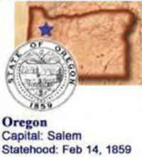
| Official Name | Oregon | |
| Capital | Salem | |
| Nicknames | Beaver State ...and more | |
| Motto | Alis Volat Propriis Latin: (She flies with her own wings) | |
| Location Region |
44.92450 N, 123.02205 W Pacific States Northwestern Northwest, Pacific |
|
| Constitution Ratified | 1859 | |
| Statehood | February 14, 1859 33rd State |
|
| Population | 3,831,074 (2010) 35.64 sq. mi. 28th |
|
| Largest City (by population) |
10 largest cities (2010 est.):Portland, 583,776; Eugene, 156,185; Salem 154,637; Gresham, 105,594; Hillsboro, 91,611; Beaverton, 89,803; Bend, 76,639; Medford, 74,907; Springfield, 59,403; Corvallis, 54,462 | |
| Bordering States | North: Washington (Columbia River forms much of the Northern boundary) East: Idaho South: Nevada and California West: Pacific Ocean Coastline: 296 mi. |
|
| Major Industry | timber, paper products, farming (wheat, cattle), mining (coal), computer equipment, electronics | |
| Major Rivers | Columbia River, Deschutes, Willamette River, John Day River, Snake River | |
| Major Lakes | Upper Klamath Lake, Crater Lake | |
| Oregon Counties | 36 Counties in Oregon | |
| Largest Counties (by population) |
Multnomah County 735,334 (2010) 435 sq. mi. |
|
| Largest Counties (by area) |
Harney County 10,135 sq mi. |
|
| State forests | 780,000 ac. | |
| State parks | 231 (95,462 ac.) | |
| Electoral Votes | 7 | |
| US Congress | 2 Senators; 5 Representatives | |
| Time Zone | Pacific Standard Time Mountain Standard Time |
|
| Zip Codes | NANPA | |
| State Quick Facts | Census Bureau Quick Facts | |
Oregon Climate and Weather |
|
|---|---|
| Weather varies significantly across Oregon,
but overall, winters are often cool and wet, with summers dry and warm. Mean temperatures average 38 degrees in January and 67 degrees in July. Cooler condition exist in the east and southeast, while it's warmer in the southwest. About 50% of all precipitations falls in winter. Amounts vary from 8 inches annually in the drier plateau regions east of the Cascades, to as much as 200 inches in the higher elevation of the Coast Range mountains. Snow amounts approach 350 to 550 inches annually in the Cascades. |
|
| Highest Temperature | 119 degrees August 10, 1938 - Pendleton |
| Lowest Temperature | -54 degrees February 10, 1933 - Seneca |
| Avg. Temp: High - Low |
82.6 degrees 32.8 degrees |
Oregon Points of Interest |
|
| Columbia River Gorge, Crater Lake, Mt. Hood and the Cascades, Hells Canyon National Recreation Area, Portland (the City of Roses), Bonneville Dam on the Columbia, Oregon Caves National Monument, Cape Perpetua in Siuslaw National Forest, and the historic communities and lighthouses along the Pacific Ocean coastline. | |
Oregon Highest, Lowest, and Mean Elevations (Feet) |
|
| Mean Elevation: 3,300 feet | |
|
Highest Point: Mt. Hood: 11,239 feet
|
|
| Lowest Point: | Pacific Ocean Sea level |
Oregon Land Area (Square Miles) |
|
| Geographic Center | In Crook County, 25 mi. SSE of Prineville Longitude: 120°58.7'W Latitude: 43°52.1'N |
| Total Area | 98,380.64 sq. mi. 9th |
| Land Area | 95,996.79 sq. mi. 97.58% |
| Water Area | 2,383.85 sq. mi. 2.42% |
| Forested Land Area | 48.4% |
| Dimensions (Length - Width) |
360 miles - 261 miles |
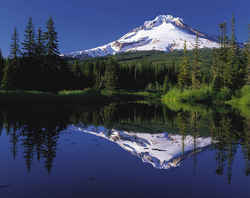 Mount Hood (45.4N, 121.7W) is the
tallest mountain in Oregon. It is 45 miles (75 km) east-southeast of Portland, Oregon. Mount Hood is a stratovolcano made of lava flows, domes, and
volcaniclastic deposits. Most of the volcano is andesite composition. The main cone of Mount Hood formed about 500,000 years ago. In the last 15,000
years the volcano has had four eruptive periods. During the most recent eruptive period, 250-180 years ago, lava domes collapsed and produced numerous
pyroclastic flows and lahars which buried the southwest flank of the mountain.
Mount Hood (45.4N, 121.7W) is the
tallest mountain in Oregon. It is 45 miles (75 km) east-southeast of Portland, Oregon. Mount Hood is a stratovolcano made of lava flows, domes, and
volcaniclastic deposits. Most of the volcano is andesite composition. The main cone of Mount Hood formed about 500,000 years ago. In the last 15,000
years the volcano has had four eruptive periods. During the most recent eruptive period, 250-180 years ago, lava domes collapsed and produced numerous
pyroclastic flows and lahars which buried the southwest flank of the mountain.Baker, Benton, Clackamas, Clatsop, Columbia, Coos, Crook, Curry, Deschutes, Douglas, Gilliam, Grant, Harney, Hood River, Jackson, Jefferson, Josephine, Klamath, Lake, Lane, Lincoln, Linn, Malheur, Marion, Morrow, Multnomah, Polk, Sherman, Tillamook, Umatilla, Union, Wallowa, Wasco, Washington, Wheeler, Yamhill

