


Oregon Geography: The Land
Geography and Landforms of Oregon
 Find
an overview of Oregon geography, topography, geographic land regions, land areas, and major rivers.
Find
an overview of Oregon geography, topography, geographic land regions, land areas, and major rivers.
Access Oregon almanac furnishing more details on the state geography, geographical and land regions, climate and weather, elevation, land areas, bordering states, and other statistical data.
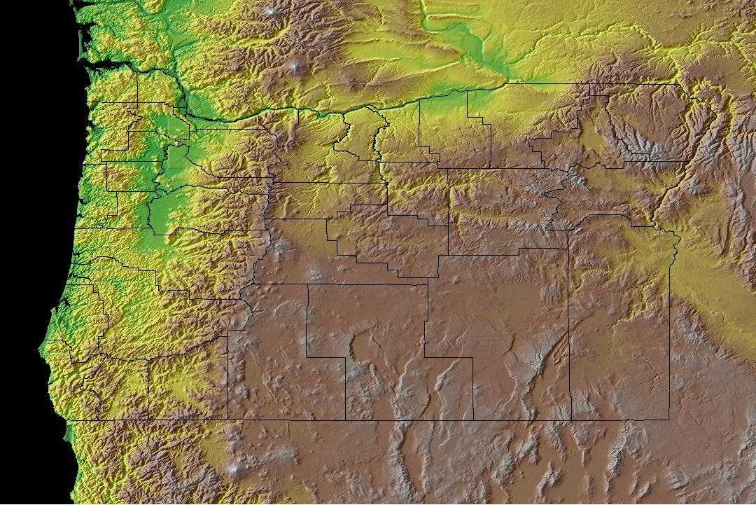
Oregon is bordered by Washington on the north and California and Nevada on the south. On the east, Oregon is bordered by Idaho and on the west, the state is bordered by the Pacific Ocean.
Major rivers in Oregon include the Columbia, Deschutes,
Willamette, John Day and Snake Rivers.
Oregon is known for its forests where about 1/10 of the nation's timber resides. In fact, Oregon is the leading provider of lumber in the United States.
Oregon Highest, Lowest, & Mean Elevations |
|
|---|---|
| Mean Elevation | 3,300 ft. |
| Highest Point | Mt. Hood11,239 ft. |
| Lowest Point | Pacific Ocean Sea level |
Oregon Land Area (Square Miles) |
|
| Geographic Center | In Crook County, 25 mi. SSE of Prineville Longitude: 120° 58.7'W Latitude: 43° 52.1'N |
| Total Area | 98,380.64 sq. mi. 9th |
| Land Area | 95,996.79 sq. mi. 97.58% |
| Water Area | 2,383.85 sq. mi. 2.42% |
| Forested Land Area | 48.4% |
| Dimensions (Length - Width) |
360 miles - 261 miles |
Oregon: Physiographic Regions
Oregon's geography can be divided into six areas;
- the Coast Range,
- the Willamette Lowland,
- the Cascade Mountains,
- the Klamath Mountains,
- the Columbia Plateau, and the
- Basin and Range Region.
Coast Range
This area runs north and south along the Pacific Ocean coast and is made up of low mountain ranges covered with evergreens like spruce, fir and hemlock. Cliffs rise almost 1,000 feet high over the Pacific Ocean. Located in this region is the Triangle Lake Valley, a very ancient lake. There are many coastal lakes scattered throughout this region. The average mountain height is less than 2,000 feet above sea level that runs through Mary's Peak. Southwest of Corvalis, Oregon heights reach 4,097 feet above sea level.
Willamette Lowlands
The climate is mild and the soil is rich in the Willamette Lowlands. This region is a narrow strip of land to the east of the Coast Range along the Willamette River. This river runs north into the Columbia River.
Cascade Mountains
Mount Hood is the highest point in Oregon, located in the Cascade Mountains is 11,239 feet above sea level. The Cascade Mountains are a rugged landscape where many of the nation's highest peaks can be found. Mt. Jefferson is another high peak rising to 10,497 feet above sea level, Three Sisters is over 10,000 feet above sea level and Mount McLoughlin, 9,495 feet above sea level. Crater Lake is the deepest lake in the United States (1,932 feet deep!) can be found in this area along with many other lakes. The Cascade Mountains lie east of the Willamette Lowlands.
Klamath Mountains
The Klamath Mountains are covered by dense forests. They are located in the southwest corner of Oregon.
Columbia Plateau
The Columbia Plateau was formed thousands of years ago by lava flowing from the cracks in the earth's crust. Wheat farms are found in this region. Most of the Columbia Plateau is rugged. The Blue Mountains and the Wallowa Mountains rise in the northeast. Hells Canyon is on the Oregon/Idaho border on the Snake River. The average depth of this gorge, located between the Wallowa Mountains and the Seven Devils Mountains in Idaho, is 5,500 feet. The Columbia Plateau cover most of extern Oregon and extends into Idaho and Washington.
This is an arid sagebrush steppe and grassland surrounded on the north, west, and east by moister, predominantly forested, mountainous ecological regions. It is an oddly shaped physiographic area that covers portions of Washington, Oregon, Idaho, Nevada, and a small piece of northeast California. It consists of arid tablelands, intermontane basins, dissected lava plains, and widely scattered low mountains. There is a more subtle transition to the Basin and Range to the south in which hotter lowlands are dissected by isolated mountain ranges.
Basin and Range Region
This region is marked by high basins and a few steep mountains. Much of the region is semi-desert. This region covers a section of southeastern Oregon.
Oregon Landscape and Landforms:
Central Rocky Mountains
The Central Rockies is a huge physiographic area, extending from northwest Wyoming over all of western Montana, the northern 2/3 of Idaho, large areas of eastern Oregon and Washington, much of southeast British Columbia and a sliver of west Alberta. It is an area of high mountains, with elevations up to 2,700 m (9,000 ft). Glaciation has left broad flat valleys between mountain ranges. Elevation determines the dominant vegetation. Highest areas are alpine tundra. The subalpine zone is dominated by Engelmann spruce and subalpine fir, with ponderosa pine and Douglas fir in the montane zone below that. Stand-replacement fire can change forests in either of those zones to lodgepole pine or aspen. Grass and sagebrush occur under open pine forests that grade downslope into grasslands, woodlands, or shrubsteppe.
Southern Pacific Rainforests
This moist physiographic area extends from the Pacific coastline of Washington and Oregon inland to the crest of the Cascade Mountains. It ends arbitrarily at the Canadian border, and also includes the coastal ranges of northwestern California. Save for coastal estuaries and some inland drier valleys (the Willamette and the Puget Trough), the natural vegetation is coniferous forest. There are six coniferous forest types, defined by elevation and latitude, including the coastal Sitka spruce zone, low-elevation western hemlock/western red cedar, mid-elevation Pacific silver fir zone, subalpine mountain hemlock, a mixed-conifer zone in the Klamath/Siskiyou Mountains, and the redwood forest of northwest California.

