Utah Counties
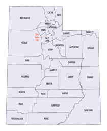
There are twenty-nine counties in the State of Utah. There were originally seven counties established under the provisional State of Deseret in 1849: Davis, Iron, Sanpete, Salt Lake, Tooele, Utah, and Weber. The Territory of Utah was created in 1851 with the first territorial legislature meeting from 1851-1852. The first legislature re-created the original counties from the State of Deseret under territorial law as well as establishing three additional counties: Juab, Millard, and Washington. All other counties were established between 1854 and 1894 by the Utah Territorial Legislature under territorial law except for the last two counties formed, Daggett and Duchesne.Cache County, Utah
Cache County Education, Geography, and History

Cache County is a county located in the state of Utah. Based on the 2010 census, the population was 112,656. Its county seat and largest city
is Logan. The county was created in 1856 and organized the next year. It was named for the fur stashes made by many of the Rocky Mountain Fur
Company trappers.
Cache County is included in the Logan, UT-ID Metropolitan Statistical Area.
Etymology - Origin of Cache County Name
Cache County derived name was from the French verb cacher, "to hide," because early trappers in Cache Valley concealed their pelts and supplies for safekeeping
Demographics:
County QuickFacts: CensusBureau Quick Facts
Cache County History
Cache County, located in the northern part of the state, is bordered by the Wasatch Mountains on the east and a spur of the Wasatch, the Wellsville Mountains, on the west. The Bear River flows through the northwestern corner of the county where the Little Bear, Blacksmith Fork, and Logan rivers add their waters to it. Cache County was formed in 1864 by the territorial legislature and its boundaries redefined in 1864 when part of Cache became Richland (Rich) County. Cache Valley was occupied by prehistoric hunters and gatherers, perhaps as early as 10,000 years ago, and served much later as a rendezvous for Plains groups and the local Shoshone. Cache Valley was repeatedly visited by trappers and explorers such as John Weber and Jim Bridger in 1824 and Peter Skene Ogden and James Beckwourth in 1825.Settlement of Cache Valley by the Mormons began in 1855 when a group organized by Bryant Stringham drove a herd of cattle into the valley on July 29 and camped at Haw Bush Spring, later known as Elkhorn Ranch. Because the winter of 1855-56 was so severe, the cattle were driven back to the Salt Lake Valley. Peter Maughan, sent to Cache Valley in 1856, founded a permanent settlement called Maughan's Fort, the present town of Wellsville. More settlers began to arrive, and five towns (Providence, Mendon, Logan, Richmond, and Smithfield) were settled in 1859. The Utah Northern Railroad between Brigham City and Logan was completed in early 1873 and later extended into Idaho. Then, a branch line from Brigham City to Corinne tied Cache County to the transcontinental line. The railroad provided jobs for Cache residents and also opened new markets for their farm output, especially grain and dairy products. By 1880 national market trends had begun to affect the local farm economy. Advances in dry-farming techniques and canal and reservoir construction increased farm production, fruit and vegetables became cash crops, and the building of grain elevators in the 1890s allowed Cache farmers to store grain until prices improved. The county's sheep herds grew from 10,000 in 1880 to 300,000 by 1900, and dairy cows numbered 16,000 by 1910. Commercial creameries, flour mills, woolen mills, and knitting factories developed around Cache's booming turn-of-the-century farm production. Today, Cache continues as the state's leader in dairy products and as a major producer of hay, alfalfa, and grain. The founding of Utah State University in Logan as a land-grant agricultural college in 1888 provided the key to the county's future. USU's scientific research, agricultural extension services, and experimental farms have benefited farmers locally and in every part of the state. With some 12,000 students currently enrolled, USU has grown to be the county's largest single employer. Course offerings now include almost all academic subjects, and the university has become a major cultural resource for the community. A variety of manufacturing firms, retail trade, and services (including government services) contribute to Cache County's diversified economy in the 20th century.*Source. Beehive History 14: Utah Counties. 1988. Utah State Historical Society, 300 Rio Grande, Salt Lake City, UT 84101-1182
Geography: Land and Water
As reported by the Census Bureau, the county has a total area of 1,173 square miles (3,038 km2), of which, 1,165 square miles (3,016 km2) of it is land and 9 square miles (22 km2) of it (0.73%) is water.
The Cache Valley and surrounding mountains are located in the county, which reaches up to the Idaho border. The Bear River Mountains, the
northernmost extension of the Wasatch Range, which reach as high as 10,000 feet (3048 m), cover the eastern half of the county. The Bear River
flows through Cache Valley. Wellsville was the first European settlement in the county, settled by Peter Maughan in 1853.
On the western edge of the county lies the Wellsville Mountains and on the eastern edge lie the Bear River
Mountains, both northern branches of the Wasatch Range. A canyon carves its way through the Wellsville
Mountains. Up this canyon climb US Routes 89 and 91 together. In downtown Logan the highways split, with US-91
heading north into Idaho and US-89 heading east and northeast into Logan Canyon. Taking up the land between the
Wellsville and Bear River Mountains is Cache Valley, a relatively flat valley traversed by the Bear River and
dotted with small farm towns in the west and the larger, more urban, and faster-growing areas in the east, along
the benches of the Bear River Mountains. The county climbs to an elevation of 9,980 ft (3,042 m) at Naomi Peak
in the Bear River
Neighboring Counties
Bordering counties are as follows:
- Box Elder County, Utah - (west)
- Weber County, Utah - (south)
- Rich County, Utah - (east)
- Franklin County, Idaho - (north)
- Oneida County, Idaho - (northwest)
Education


