

Click Image to Enlarge
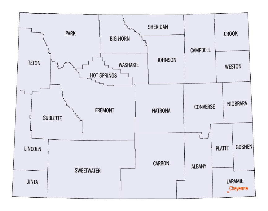
Wyoming Counties
There are twenty-three Counties in the state of Wyoming. There were originally five Counties in the Wyoming Territory: Laramie and Carter, established in 1867; Carbon and Albany established in 1868; and Uinta, an annexed portion of Utah and Idaho, extending from Montana (including Yellowstone Park) to the Wyoming-Utah boundary. On July 10, 1890, Wyoming was admitted to the Union with thirteen counties.Sheridan County, Wyoming
Sheridan County Education, Geography, and History
Sheridan County is a county located in the state of Wyoming. Based on the 2010 census, the population was 29,116. The county seat is
Sheridan. It is south from the Montana state line.
Sheridan County comprises the Sheridan, WY Micropolitan Statistical Area.
Etymology - Origin of Sheridan County Name
Named in honor of General Philip Sheridan of Civil War fame.
Demographics:
County QuickFacts: CensusBureau Quick Facts
Sheridan County History
Sheridan County was created by the legislature of the Wyoming Territory on March 9, 1888. The county was formed
from land ceded from Johnson County. Sheridan County was named for Philip Sheridan, a general in the American Civil War and controversial
Indian fighter.
In 1897, Big Horn County was created by removing lands from Sheridan County, along with lands from Fremont County, and Johnson County. The
boundaries of Sheridan County were slightly modified in 1911 and 1929, but have remained stable since then.
Geography: Land and Water
As reported by the Census Bureau, the county has a total area of 2,527 sq mi (6,545 km2) making it over 1000 square miles larger than the state of Rhode Island. 2,523 sq mi (6,535 km2) of it is land, and 4 sq mi (10 km2) of it (0.15%) is water.
Sheridan County is located halfway between Yellowstone National Park and the Black Hills of South Dakota, at the
base of the majestic Big Horn Mountains. Sheridan is surrounded by historic spots: Fort Phil Kearny to the south,
Little Big Horn Battlefield to the north, the Medicine Wheel to the west and Devil's Tower to the east. Interstate
90, US Highways 14, 14A and 87 provide access to Sheridan County.
Neighboring Counties
Bordering counties are as follows:
- Big Horn County, Montana (north)
- Powder River County, Montana (northeast)
- Campbell County (east)
- Johnson County (south)
- Big Horn County (west)
Education


Click Image to Enlarge
