

Click Image to Enlarge
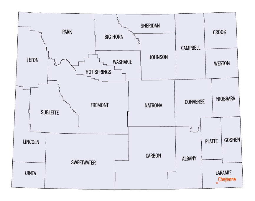
Wyoming Counties
There are twenty-three Counties in the state of Wyoming. There were originally five Counties in the Wyoming Territory: Laramie and Carter, established in 1867; Carbon and Albany established in 1868; and Uinta, an annexed portion of Utah and Idaho, extending from Montana (including Yellowstone Park) to the Wyoming-Utah boundary. On July 10, 1890, Wyoming was admitted to the Union with thirteen counties.Weston County, Wyoming
Weston County Education, Geography, and History
Weston County is a county located in the state of Wyoming. Based on the 2010 census, the population was 7,208. Its county seat is Newcastle. It is west from the South Dakota state line.
Etymology - Origin of Weston County Name
Named for John B. Weston, whose activities and influence brought the railroad into that section of Wyoming.
Demographics:
County QuickFacts: CensusBureau Quick Facts
Weston County History
Weston County was created by the legislature of the Wyoming Territory on March 12, 1890. The county was created out
of a portion of Crook County.
Weston County was named for John B. Weston, who was a geologist and surveyor. In 1887, John Weston and Frank Mondell found rich coal deposits
north of Newcastle which caused a railroad to be built through the area.
In 1911, Campbell County was formed from portions of Weston County and Crook County. Since then, the boundaries of Weston County have been
stable.
Weston County is located in the northeastern corner of Wyoming. Located on the western edge of the beautiful Black Hills, to the west and south are amazing prairies and grasslands, filled with wildlife just waiting for you to view. You will see antelope, white-tail and mule deer, prairie dogs, wild turkey, Canada geese, perhaps even elk.
Because this is old-fashioned family ranching country, you will also see a wide variety of cattle, sheep, and
horses. And since these communities are small, the air and water are clear and fresh. The views are
breath-taking.
Geography: Land and Water
As reported by the Census Bureau, the county has a total area of 2,400 square miles (6,216 km2), of which,
2,398 square miles (6,210 km2) of it is land and 2 square miles (6 km2) of it (0.09%) is water.
Neighboring Counties
Bordering counties are as follows:
- Crook County (north)
- Lawrence County, South Dakota (northeast)
- Pennington County, South Dakota (east)
- Custer County, South Dakota (southeast)
- Niobrara County (south)
- Converse County (southwest)
- Campbell County (west)
Education


Click Image to Enlarge
