


Click Image to Enlarge
California Counties
The state of California is divided into fifty-eight counties. On January 4, 1850, the California constitutional committee recommended the formation of 18 counties. They were Benicia, Butte, Fremont, Los Angeles, Mariposa, Monterey, Mount Diablo, Oro, Redding, Sacramento, San Diego, San Francisco, San Joaquin, San Jose, San Luis Obispo, Santa Barbara, Sonoma, and Sutter. The last California county to have been established is Imperial County in 1907.Madera County, California
Madera County Education, Geography, and History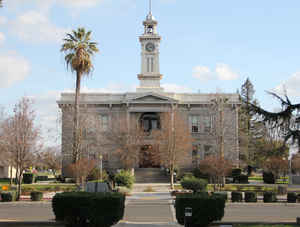
Madera County, officially the County of Madera, is a county at the geographic center of the state of California. Based on the 2010 census, the population was 150,865. The county
seat is Madera. Madera county was formed
on March 11, 1893. The county is named for a Spanish
work meaning "timber".
Madera County comprises the Madera, CA Metropolitan Statistical Area, which is included in the Fresno-Madera, CA Combined Statistical Area. It
is located in the Central Valley and the Sierra Nevada.
Etymology - Origin of Madera County Name
Madera county was created in 1893, from a portion of Fresno County lying north of the San Joaquin River. Madera in Spanish signified "timber." The county derived its name from the town of Madera, named when the California Lumber Company built a flume to carry lumber to the railroad there in 1876.
Demographics:
County QuickFacts: CensusBureau Quick Facts
Madera County History
Madera County was formed in 1893 from parts of Fresno County.
"Madera" is the Spanish word for "lumber", the first industry in the County. Part of the historic Sugar Pine Railroad
remains as a tourist attraction. One of the
engineering marvels of early California was a huge flume that ran from the high
Sierra Forest area down to Madera. Its history is preserved in articles and photos in the County Museum located in
the beautiful old granite Courthouse in Madera. A replica of a section of the flume is on display. The Raymond Granite
Company quarry supplies granite for some of the nation's outstanding public edifices. The mountain area is rich in the
history of the 1859 California Gold Rush towns, with such names as Coarsegold, Finegold, Grub Gulch, Ahwahnee and
Nipinnawassee. Panning for gold is still popular for both fun and profit. In 1855, a portion of Madera County separated
from Mariposa County when Fresno became a County and in 1856, the rest of Madera separated from Mariposa County and
became a County.
The growth of the territory known as Madera County has progressed in waves. The first small wave of men was composed of
a few explorers, soldiers, trappers, and Spanish speaking settlers with Mexican land grants. These men came in the first
half of the last century, and few stayed longer than a few months.
The discovery of gold brought the first big wave of immigrants, most of them placer miners who worked along the streams
that were rich in precious metal, and soon a new mining era came with the development of hard-rock ledge mining for
gold, silver and copper.
In 1919, a group known as the Gold Chain Council was formed to get what was then a dirt road of various qualities,
conditions and dimensions made into a State highway. It obviously was successful, and continues to this day as the
oldest highway association in California.
The State Legislature officially named Highway 49 the "Mother Lode Highway" in 1921. At that time, it extended south
only as far as Mariposa, and the section from Mariposa to Oakhurst was known as Bootjack Road. In 1969, the State
Highway Commission and State Legislature finally incorporated Bootjack Road into Highway 49. Oakhurst rightfully
received recognition and was legitimized as the southern terminus of the scenic and famous route which winds its way
through eleven counties.
Gold fever hit the hills here in 1849 and 50 but the actual gold rush came more slowly. Previously, no one had any good
reason to explore the mountains and they had remained virtually uninhabited wilderness.
The records show that one early resident of the area, Jim Savage, employed Chinese to work the San Joaquin River for
him. At first, Jim was involved in fighting the Indians, but as the area became more populated, he made friends with
them, even to the extent of marrying at least five Indian girls, one from each tribe. He is given credit for the
discovery of Yosemite Valley on March 27, 1851, and named it after the tribe which
occupied it.
Legend has it that at one time there were 5,000 residents in Grub Gulch and 10,000 in Coarsegold. However, local records
do not confirm these figures. An 1853 Army report placed a considerable number of Chinese at Millerton and in Coarsegold
Gulch in 1854. Later 2,000 were reported to have worked in the Raymond area. There is considerable evidence of Chinese
labor in that area; miles of stone walls meander through hills between Raymond and Mariposa. Local ranchers hired the
Chinese to clear their fields of rocks and to use them for boundary fences. They were built without mortar and still
stand today.
Geography: Land and Water
As reported by the Census Bureau, the county has a total area of 2,153 square miles (5,577 km2), of which, 2,136 square miles (5,532 km2) of it is land and 17 square miles (45 km2) of it is water. The total area is 0.81% water.
Madera County is surrounded by the crest of the Sierra Nevada on the
east, by the Chowchilla River on the north and by the San Joaquin River
on the south and west. Midway through this land flows the Fresno River.
Out of these three rivers, the San Joaquin is the only one large enough
to establish a year-round water course; and as it reaches the lowest
point of the plains, turns northwesterly and by its arc define the
extent of Madera County on two sides.
Neighboring Counties
Bordering counties are as follows:
- North: Tuolumne County
- Northeast: Mono County
- South: Fresno County
- West: Merced County
- Northwest: Mariposa County
Education


Click Image to Enlarge
