California Counties
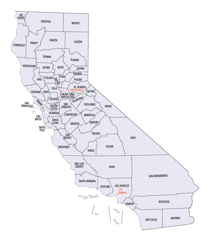
The state of California is divided into fifty-eight counties. On January 4, 1850, the California constitutional committee recommended the formation of 18 counties. They were Benicia, Butte, Fremont, Los Angeles, Mariposa, Monterey, Mount Diablo, Oro, Redding, Sacramento, San Diego, San Francisco, San Joaquin, San Jose, San Luis Obispo, Santa Barbara, Sonoma, and Sutter. The last California county to have been established is Imperial County in 1907.Monterey County, California
Monterey County Education, Geography, and History
Monterey County is a county located on the Pacific coast of the state of California. Based on the 2010 census, the
population was
415,057. The county seat and largest city is Salinas.
Monterey county was created February 18, 1850. The
county is named from the Bay of Monterey. Monterey is
composed of the Spanish words monte and rey, and factually means "king
of the forest."
Monterey County comprises the Salinas, CA Metropolitan Statistical Area. It borders the Monterey Bay. The northern half of the bay is in Santa
Cruz County. Monterey County is a member of the regional governmental agency, Association of Monterey Bay Area Governments.
Etymology - Origin of Monterey County Name
Monterey county derived its name from the Bay of Monterey. The word, Monterey is composed of the Spanish words monte and rey, and literally means "king of the forest." The bay was named by Sebastian Vizcaino in 1602, in honor of the Conde de Monterey, the Viceroy of New Spain.
Demographics:
County QuickFacts: CensusBureau Quick Facts
Monterey County History
Monterey County was one of the original counties of California, created in 1850 at the time of statehood. Parts of the county were given to San Benito County in 1874.
Geography: Land and Water
As reported by the Census Bureau, the county has a total area of 3,771 square miles (9,767 km2), of which, 3,322 square miles (8,604 km2) of it is land and 449 square miles (1,163 km2) of it (11.91%) is water. The county is roughly 1.5 times larger than the state of Delaware.
Monterey County on the California Central Coast has a varied
coastline that includes the remote region of Big Sur and the urban areas
on Monterey Bay. The Big Sur Coast makes up about two-thirds of Monterey
County's waterfront and stretches from Carmel down to San Luis Obispo
County. In this long mostly unpopulated area Highway 1 runs along the
scenic headlands with access to many beaches.
Neighboring Counties
Bordering counties are as follows:
- Northeast: San Benito County; Fresno County
- East: Kings County
- Southeast: Kern County; San Luis Obispo County
- Southwest: North Pacific Ocean
- Northwest: Santa Cruz County
Education


