


Click Image to Enlarge
California Counties
The state of California is divided into fifty-eight counties. On January 4, 1850, the California constitutional committee recommended the formation of 18 counties. They were Benicia, Butte, Fremont, Los Angeles, Mariposa, Monterey, Mount Diablo, Oro, Redding, Sacramento, San Diego, San Francisco, San Joaquin, San Jose, San Luis Obispo, Santa Barbara, Sonoma, and Sutter. The last California county to have been established is Imperial County in 1907.San Bernardino County, California
San Bernardino County Education, Geography, and History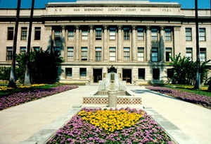
San Bernardino County, California, officially the County of San Bernardino, is a county located in the southern portion of the state
of California. Based on the 2010 census, the population was 2,035,210, making it the fifth-most populous county in California, and the 12th-most
populous. The county seat is San Bernardino.
San Bernardino county was created April 26, 1853. Saint
Bernard is the patron saint of mountain passes. The name
Bernardino means "bold as a bear."
San Bernardino County is included in the Riverside-San Bernardino-Ontario, CA Metropolitan Statistical Area, also known as the Inland Empire,
as well as the Los Angeles-Long Beach, CA Combined Statistical Area.
Etymology - Origin of San Bernardino County Name
Saint Bernard is the patron saint of mountain passes. The name Bernardino means "bold as a bear." The Spanish gave the name San Bernardino to the snowcapped peak in southern California, in honor of the saint; from him the county derived its name.
Demographics:
County QuickFacts: CensusBureau Quick Facts
San Bernardino County History
Father Francisco Dumetz named San Bernardino on May 20, 1810, feast day of St. Bernardino of Siena.
San Bernardino County was formed from parts of Los Angeles County in 1853. Parts of the county's territory were given to
Riverside County in 1893.
Paleo-Indian sites dating from 10,000 BC show that the San Bernardino county area has been inhabited for at least
12,000 years. Artifacts in the Calico area suggest much earlier human occupation, but this has not been confirmed. In
the past three thousand years various Indian tribes flourished in the area: the Gabrielenos occupied the West Valley;
the Serranos lived in the foothills of the San Bernardino Mountains; the Vanyumes lived along the Mojave River; the
Mohave lived along the Colorado River; and in the 1500s the Chemehuevi moved into the Mojave Desert.
The first explorers to enter the area were Pedro Fages, Military Commander of California, in 1772 and Fr. Francisco
Garces, a missionary priest, in 1774. On May 20, 1810, Franciscan missionary Francisco Dumatz, of the San Gabriel
Mission, led his company into a valley. In observance of the feast day of St. Bernardine of Siena, Dumatz named the
valley San Bernardino. This name was later given to the nearby mountain range, and later the city and county.
In 1842 the Lugo family was granted the Rancho San Bernardino, a holding of 37,700 acres
surrounding the entire San
Bernardino Valley. Captain Jefferson Hunt, of the Mormon Battalion, led a group of settlers into San Bernardino.
The Mormon Colony purchased the Rancho from the Lugos in 1851.
In 1857 three orange trees were set out on a farm in Old San
Bernardino; by 1882 a rail car load of oranges and lemons grown in the
East Valley was being shipped to Denver. As early as the 1840s vineyards
were planted in the Cucamonga area and in the 1870 census San Bernardino
County was credited with producing 48,720 gallons of wine.
In 1860 gold was discovered in Holcomb and Bear Valleys in the San Bernardino Mountains, and placer mining began in
Lytle Creek. Silver was being mined at Ivanpah in 1870, and the rich silver mines of the Calico district were developed
in the 1880s. Borax was first discovered in 1862 in the Searles Dry Lake area near Trona, and transported out by
twelve-, eighteen- or twenty-mule team wagons.
I
Several noted people have been associated with San Bernardino County history. Jedediah Smith was an early explorer (1826);
Kit Carson traversed the Cajon Pass with a group of trappers in 1830; as a teenager Wyatt Earp and his family traveled
to San Bernardino by wagon train, arriving in 1864; President Lyndon Johnson worked as an elevator operator in the Platt
Building in San Bernardino in 1925; and President Bill Clinton visited the recently closed Norton Air Force Base in May
1994.
Geography: Land and Water
The Mojave National Preserve covers some of the eastern desert. The desert portion also includes the cities of Needles next to the Colorado River, and
Barstow. Trona is at the northwestern part of the
county west of Death Valley. This famous national park, mostly within Inyo County, also has a small
portion of land within the county. The largest metropolitan area in the Mojave Desert part of the county
is the Victor Valley. Further south, a portion of Joshua Tree National Park overlaps the county near Twentynine
Palms. Additional places near and west of Twentynine palms include Yucca Valley, Joshua Tree, and
Morongo Valley.
The mountains are home to the San Bernardino National Forest, and
include the communities of Crestline, Lake Arrowhead, Running Springs, Big Bear City, Forest Falls, and
Big Bear Lake.
The San Bernardino Valley is at the eastern end of the San Gabriel Valley, and is part of the Inland
Empire.
The Inland Empire area of Southern California is made up of the southwestern portion of San Bernardino
County and western portion of Riverside county.
Neighboring Counties
Bordering counties are as follows:
- Northeast: Clark County, Nev.; Mohave County, Ariz.
- Southeast: La Paz County, Ariz.
- South: Riverside County
- Southwest: Orange County; Los Angeles County
- West: Kern County
- Northwest: Inyo County
Education


Click Image to Enlarge
