


Click Image to Enlarge
California Counties
The state of California is divided into fifty-eight counties. On January 4, 1850, the California constitutional committee recommended the formation of 18 counties. They were Benicia, Butte, Fremont, Los Angeles, Mariposa, Monterey, Mount Diablo, Oro, Redding, Sacramento, San Diego, San Francisco, San Joaquin, San Jose, San Luis Obispo, Santa Barbara, Sonoma, and Sutter. The last California county to have been established is Imperial County in 1907.Yolo County, California
Yolo County Education, Geography, and History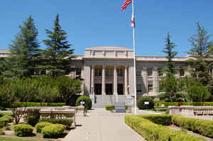
Yolo County, officially the County of Yolo, is a county located in the northern portion of the state of California. Based on the 2010 census, the population was 200,849. The county
seat is Woodland, and its largest city is Davis. The
county was created February 18, 1850. Yolo county
is named from an Indian name believed to be a version
of an Indian tribal name Yo-loy meaning "a place abounding in rushes"or
of the name of the Indian chief, Yodo, or of the Indian village of Yodoi.
Yolo County is included in the Sacramento-Roseville-Arden-Arcade, CA Metropolitan Statistical Area. The county is located in the Sacramento
Valley.
Etymology - Origin of Yolo County Name
In the original act of 1850, the name was spelled "Yola." Yolo is an Indian name variously believed to be a corruption of an Indian tribal name Yo-loy meaning "a place abounding in rushes" or of the name of the Indian chief, Yodo, or of the Indian village of Yodoi.
Demographics:
County QuickFacts: CensusBureau Quick Facts
Yolo County History
Yolo County was one of the original 27 counties created when California became a state in
1850.
In the original act of 1850 the name was spelled "Yola." Yolo is a Native American name variously believed to be a
corruption of a tribal name Yo-loy meaning "a place abounding in rushes" or of the name of the chief, Yodo, or of the
village of Yodoi. To some, Yolo also serves as an acronym for "you only live once".
The first recorded contact with Westerners occurred in the late 1830s. These included Spanish missionaries as well as
trappers and hunters who could be found along the banks of "Cache Creek"- named by French-Canadian trappers. The first
white settler was William Gordon who received a land grant from the Mexican government in 1842 and began planting wheat
and other crops.
The towns of Yolo County were out-growths of native villages along waterways.
The countys' first town, Fremont, was founded in
1849 along the confluence of the Sacramento and Feather Rivers and became the first county seat. Knights Landing,
Washington, Cacheville (later called Yolo), Clarksburg, Winters, Esparto, Capay, Guinda, and Davisville (Davis) were all
built near waterways. Davisville had the added advantage of being on the path of the newly constructed railroad.
Woodland, which became the county seat in 1862, began in a wooded area of valley oaks and was also served by a nearby
railroad.
Geography: Land and Water
As reported by the Census Bureau, the county has a total area of 1,023 square miles (2,649 km2),
of which, 1,013 square miles (2,624 km2) of it is land and 10 square miles (25 km2) of it (0.94%) is
water.
Yolo County 653,549 acres is located in the rich agricultural regions of
California's Central Valley and the Sacramento River Delta.
The county is directly west of Sacramento, the State
Capital of California, and northeast of the Bay Area counties of Solano and Napa. The eastern two-thirds
of the county consists of flat plains and basins. The western third is
largely composed of rolling terraces and steep uplands used for dry-farmed grain and range. The
elevation ranges from slightly below sea level near the Sacramento River around Clarksburg to 3,000 feet
along the ridge of the western mountains. Putah Creek descends from Lake Berryessa offering fishing and
camping opportunities and drifts through the arboretum of the University of California at Davis. Cache
Creek, flowing from Clear Lake, offers class II-III rapids for white water rafting and kayaking.
Neighboring Counties
Bordering counties are as follows:
- Northeast: Sutter County
- Southeast: Sacramento County
- South: Solano County
- Southwest: Napa County
- Northwest: Lake County; Colusa County
Education
Public schools
The county's public schools are managed by the Yolo County Office of Education.
Colleges and universities
- University of California, Davis
- Woodland Community College


Click Image to Enlarge
