


Click Image to Enlarge
Kansas Counties
Kansas has one hundred and five counties. Originally 33 counties were organized by the Territorial Legislature in 1855. The Chase County Courthouse in Cottonwood Falls, Kansas was built in 1873 and is the oldest operating courthouse in Kansas. As of January 1, 2009 Greeley County and the city of Tribune unified to form the Unified Government of Greeley County..Barton County, Kansas
Barton County Education, Geography, and History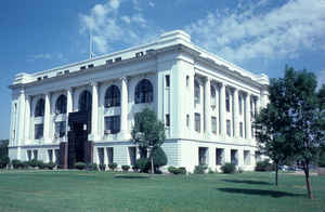
Barton County is a county located in the state of Kansas. Based on the 2010 census, the county
population was
27,674. Barton County was created on February 26, 1867.
The county seat and most populous city
is Great Bend. Barton county is named in honor of Clara Barton, responsible for the founding of
the American Red Cross.
The Great Bend, KS Micropolitan Statistical Area includes all of Barton County.
Etymology - Origin of Barton County Name
Barton County is the only current Kansas county named for a woman. It is named for Clara Harlowe Barton (1821-1912), Civil War nurse and founder of the American Red Cross.
Demographics:
County QuickFacts: CensusBureau Quick Facts
Barton County History
Barton County, nearly in the geographical center of the state, is bounded on the north by Russell county, east by Ellsworth and Rice, south by Stafford and Pawnee, and west by Pawnee and Rush counties. It is exactly 30 miles square and contains 900 square miles. The county was created by an act of 1867, and was named in honor of Clara Barton, the founder of the American Red Cross association. The southern half of Barton county lies in territory that was erected as Washington county by the act of 1855, while the northern portion includes part of the unorganized territory attached to the counties lying east of it. It is supposed that the first white men who saw this part of Kansas were the Spaniards under Coronado (q. v.).
Geography: Land and Water
Barton County was drawn in the shape of a 30-by-30-mile (48 by 48 km) square. As reported by the Census Bureau, the county has a total area of 901 square miles (2,330 km2), of which 895 square miles (2,320 km2) is land and 5.2 square miles (13 km2) (0.6%) is water.
Barton county is located close to the center of Kansas. The geographic center of Kansas is located in Barton County.
The southern part of the county is level, the northern portion higher. The valleys of the Arkansas river and Walnut creek are from 2 to 7 miles in width, with a sandy loam soil, which is very fertile and productive. Mainly cottonwood, elm, ash, box-elder, hackberry, willow and walnut, are found along the streams, and many artificial groves have been set out. Barton county is one of the excellent wheat counties of Kansas, but corn, Kafir corn and oats are extensively raised. Limestone of a good quality is found in the northern portion, and sandstone in the southern half of the county. Clay is found in the north, and a vein from 15 to 18 feet thick lies about 3 or 4 miles north of Great Bend. A rich bed of rock salt has been discovered about 3 miles northeast of Great Bend and has been drilled 100 feet.
The Arkansas river is the principal stream. Its course through the county is in the form of a bend, from which the town of Great Bend takes its name. There are several tributary streams, Walnut and Little Walnut creeks being the most important.
Neighboring Counties
Bordering counties are as follows:
- North: Russell County
- Northeast: Ellsworth County
- Southeast: Rice County
- South: Stafford County
- Southwest: Pawnee County
- West: Rush County
Education
The five school districts are part of the special education area of Barton County called Barton County Special Services.
Central Plains USD 112
Ellinwood USD 355
Great Bend USD 428
Hoisington USD 431
Otis-Bison USD 403 (Rush County)
Community colleges
Barton Community College


Click Image to Enlarge
