


Click Image to Enlarge
Kansas Counties
Kansas has one hundred and five counties. Originally 33 counties were organized by the Territorial Legislature in 1855. The Chase County Courthouse in Cottonwood Falls, Kansas was built in 1873 and is the oldest operating courthouse in Kansas. As of January 1, 2009 Greeley County and the city of Tribune unified to form the Unified Government of Greeley County..Bourbon County, Kansas
Bourbon County Education, Geography, and History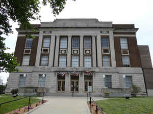
Bourbon County is a county located in Southeast Kansas. Based on the 2010 census, the county population was 15,173. Bourbon County was created on August 25, 1855. The county seat and most populous city is Fort Scott. The county is named for Bourbon County, Kentucky, the birthplace of Colonel Samuel A. Williams, a member of the Kansas House of Representatives from Fort Scott in 1855, who requested that the county be so named.
Etymology - Origin of Bourbon County Name
Bourbon county is named from Bourbon County, Kentucky, the latter having been one of the nine counties organized in 1785 by the Virginia legislature, before Kentucky became an independent state. It was so called as a compliment to the Bourbon dynasty of France, a prince of that family (then on the throne) having rendered the American colonies important aid in men and money in their great struggle for independence. Colonel Samuel A. Williams, a native of Bourbon county, Ky., was a member of the House from Fort Scott in 1855, and it was at his request that the county was so named. He was mustered in as Captain of Company I, Second Kansas Cavalry, November 22, 1861, and resigned March 28, 1862. He died at his old home, Fort Scott, in August, 1873.
Demographics:
County QuickFacts: CensusBureau Quick Facts
Bourbon County History
Bourbon County, on the Missouri border and in the third tier north of Oklahoma, is one of the 33 counties created by the first territorial legislature, with the following boundaries, "Beginning at the southeast corner of Linn county; thence south 30 miles; thence west 24 miles; thence north 30
miles; thence east 24 miles to the place of beginning." In 1867 the boundaries were defined as follows: "Beginning at the southeast corner of Linn county; thence south on the east line of the State of Kansas to the southeast corner of section 24, township 27, range 25; thence west to the southwest
corner of section 23, township 27, range 21; thence north to the southwest corner of Linn county; thence east to the place of beginning." By this second act, the extent of the county from north to south was reduced to 25 miles, and increased from east to west a little more than 25 miles, which gives
it an area of 637 square miles.
It was named after Bourbon county, Ky. At the present time it is bounded on the north by Linn county, on the east by the State of Missouri, on the north by Crawford county and on the west by Neosho and Allen counties.
Geography: Land and Water
As reported by the Census Bureau, the county has a total area of 639 square miles (1,660 km2), of which 635 square miles (1,640 km2) is land and 3.6 square miles (9.3 km2) (0.6%) is water.
Bourbon
county is located in east Kansas. The general surface of the country is
rolling hills, the highest hills being found in the northwest area. Timber
that's found along the streams contain hackberry, hickory, oak, pecan and walnut. On the
high ground and in some of the lower lands, hickory, maple, poplar and
willow have been planted. The main water-courses are the Little Osage,
which flows east, south of the northern boundary, and the Marmaton,
which flows from west to east through the central portion of the county.
The Little Osage has a few tributaries flowing into it from both north
and south, the main stream being Limestone creek in the northwest part
of the county.
The soil is deep and fertile, being layered with sandstone and limestone at various depths.
Neighboring Counties
Bordering counties are as follows:
- North: Linn County
- East: Vernon County, Mo.
- South: Crawford County
- Southwest: Neosho County
- West: Allen County
- Northwest: Anderson County
Education
Unified School Districts
Fort Scott USD 234
Uniontown USD 235


Click Image to Enlarge
