


Click Image to Enlarge
Kansas Counties
Kansas has one hundred and five counties. Originally 33 counties were organized by the Territorial Legislature in 1855. The Chase County Courthouse in Cottonwood Falls, Kansas was built in 1873 and is the oldest operating courthouse in Kansas. As of January 1, 2009 Greeley County and the city of Tribune unified to form the Unified Government of Greeley County..Jewell County, Kansas
Jewell County Education, Geography, and History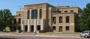
Jewell County is a county located in the state of Kansas. Based on the 2010 census, the county population was 3,077. Jewell County was created on February 26, 1867. The county seat and most populous city is Mankato. The county is named in honor of Lieutenant Colonel Lewis R. Jewell of the Sixth Kansas Cavalry.
Etymology - Origin of Jewell County Name
The county is named in honor of Lieutenant-Colonel Lewis R. Jewell, Sixth Kansas Cavalry, who died November 30, 1862, of wounds received in the battle of Cane Hill, Arkansas. November 28, 1862.
Demographics:
County QuickFacts: CensusBureau Quick Facts
Jewell County History
Jewell County, one of the northern tier, is the second county west of the 6th principal meridian. It contains 900 square miles and is divided into 25 civil townships, each of which is a Congressional township. It is bounded on the north by the State of Nebraska; on the east by Republic and Cloud
counties; on the south by Mitchell, and on the west by Smith. Jewell was one of the counties on the line of the historic Pawnee road, and also one of the counties crossed by Lieut. Pike in 1806. The surface is rolling prairie gradually rising to table lands in the central portion. The branches of
the Republican and Solomon form its water system.
This county was named in honor of Lewis R. Jewell, lieutenant-colonel of the Sixth Kansas cavalry, who died of wounds received in the battle of Cane Hill, Ark.
Geography: Land and Water
As reported by the Census Bureau, the county has a total area of 914 square miles (2,370 km2), of which 910 square miles (2,400 km2) is land and 4.6 square miles (12 km2) (0.5%) is water.
Jewell county is located in north Kansas.
Neighboring Counties
Bordering counties are as follows:
- Nuckolls County, Nebraska (northeast)
- Republic County (east)
- Cloud County (southeast)
- Mitchell County (south)
- Osborne County (southwest)
- Smith County (west)
- Webster County, Nebraska (northwest)
Education
Unified School Districts
Rock Hills USD 107


Click Image to Enlarge
