


Click Image to Enlarge
Kansas Counties
Kansas has one hundred and five counties. Originally 33 counties were organized by the Territorial Legislature in 1855. The Chase County Courthouse in Cottonwood Falls, Kansas was built in 1873 and is the oldest operating courthouse in Kansas. As of January 1, 2009 Greeley County and the city of Tribune unified to form the Unified Government of Greeley County..Pratt County, Kansas
Pratt County Education, Geography, and History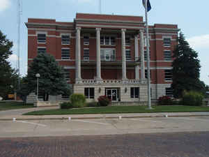
Pratt County is a county located in the state of Kansas. Based on the 2010 census, the county population was 9,656. Pratt County was created on February 26, 1867. The county seat is Pratt. The county is named in honor of Caleb S. Pratt, a Bostonian and 2nd Lieutenant for the Union during the Civil War.
Etymology - Origin of Pratt County Name
The county is named in memory of Caleb Pratt, Second Lieutenant of Company D, First Kansas Infantry, killed in action August 10, 1861 at Wilson's creek, Montna.
Demographics:
County QuickFacts: CensusBureau Quick Facts
Pratt County History
Pratt County, in the south central part of the state, is the second county from the southern line of the state and the seventh from the west line. It is bounded on the north by Stafford county; on the east by Reno and Kingman; on the south by Barber, and on the west by Kiowa and Edwards. It was
created in 1867 and named for Caleb Pratt, of the First Kansas infantry. The boundaries fixed at that time were as follows: "Commencing where the east line of range 11 west intersects the 5th standard parallel; thence south to the 6th standard parallel; thence west to the east line of range 16 west;
thence north to the 5th standard parallel; thence east to the place of beginning."
The east and west boundaries have not been changed, but the north and south lines have both been moved one tier of townships to the north. Pratt was one of the counties which experienced a fake organization before it had a single inhabitant. In 1873 a party of men from Hutchinson accomplished a
complete organization of the county, bonds were issued and a nonentity elected to the legislature. The organization was never recognized, and as the first settler did not come until the fall of that year it was 1879 before there were sufficient inhabitants to organize.
Geography: Land and Water
As reported by the Census Bureau, the county has a total area of 736 square miles (1,910 km2), of which 735 square miles (1,900 km2) is land and 0.7 square miles (1.8 km2) (0.09%) is water.
Pratt county is located close to the center of Kansas. The county is rolling prairie, almost all tillable land. Bottom lands makes up about 8 per cent of the area. Thin belts of timber line the streams. The Ninnescah river has its source in the central part of the county and flows east. The Chikaskia has its source in the south and flows southeast into Barber county. Gypsum and sandstone are found in the south and southwest.
Neighboring Counties
Bordering counties are as follows:
- Stafford County (north)
- Reno County (northeast)
- Kingman County (east)
- Barber County (south)
- Kiowa County (west)
- Edwards County (northwest)
Education
Unified School Districts
Pratt USD 382
Skyline USD 438


Click Image to Enlarge
