


Click Image to Enlarge
Kansas Counties
Kansas has one hundred and five counties. Originally 33 counties were organized by the Territorial Legislature in 1855. The Chase County Courthouse in Cottonwood Falls, Kansas was built in 1873 and is the oldest operating courthouse in Kansas. As of January 1, 2009 Greeley County and the city of Tribune unified to form the Unified Government of Greeley County..Rooks County, Kansas
Rooks County Education, Geography, and History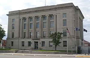
Rooks County is a county located in the state of Kansas. Based on the 2010 census, the county population was 5,181. Rooks County was created on February 26, 1867. The county seat is Stockton. The county is named for Private John C. Rooks of the 11th Kansas Infantry who died at the Battle of Prairie Grove near Fayetteville, Arkansas, during the Civil War.
Etymology - Origin of Rooks County Name
The county is named for John C. Rooks, private of Company I, Eleventh Kansas Infantry, who died December 11, 1862, at Fayetteville, Arkkansas, of wounds received in the battle of Prairie Grove, December 7, 1862.
Demographics:
County QuickFacts: CensusBureau Quick Facts
Rooks County History
Rooks County, in the northwestern section of the state, is in the second tier south of the Nebraska line, and the fifth county east from Colorado. It is bounded on the north by Phillips county; on the east by Osborne; on the south by Ellis, and on the west by Graham. The legislature defined the
boundaries in 1867 as follows: "Commencing where the east line of range 16 west intersects the 1st standard parallel; thence south to the 2nd standard parallel; thence west to the east line of range 21 west; thence north to the 1st standard parallel; thence east to the place of beginning."
It was named in honor of John C. Rooks of the Eleventh Kansas cavalry. Settlers did not begin coming into the county till 1871. By the fall of the next year there was sufficient population for county organization, which took place on Nov. 26, 1872. Gov. Harvey in his proclamation named Stockton as
the temporary county seat
The Rooks County courthouse was designed by architect Frank C. Squires and was built during the period from 1921-1924.
Geography: Land and Water
As reported by the Census Bureau, the county has a total area of 895 square miles (2,320 km2), of which 891 square miles (2,310 km2) is land and 4.6 square miles (12 km2) (0.5%) is water.
Rooks county is located in northwest Kansas. The county is rolling, with high bluffs along the south fork of the Solomon river and Paradise creek. One-fifth of the surface is almost level, and about three-fifths are rolling prairie. The south fork of the Solomon river enters on the west and flows eastward through the county. Slate and Sand creeks are branches from the northwest and Spring Lost, Box-Elder, Elm and Medicine from the south. Magnesian limestone of a excellent quality lie beneath the entire county, with quarries at Iago and on Elm and Medicine creeks. Sandstone, gypsum and potter's clay are also found.
Neighboring Counties
Bordering counties are as follows:
- Phillips County (north)
- Smith County (northeast)
- Osborne County (east)
- Ellis County (south)
- Trego County (southwest)
- Graham County (west)
Education
Unified School Districts
Palco USD 269
Plainville USD 270
Stockton USD 271


Click Image to Enlarge
