


Click Image to Enlarge
Kansas Counties
Kansas has one hundred and five counties. Originally 33 counties were organized by the Territorial Legislature in 1855. The Chase County Courthouse in Cottonwood Falls, Kansas was built in 1873 and is the oldest operating courthouse in Kansas. As of January 1, 2009 Greeley County and the city of Tribune unified to form the Unified Government of Greeley County..Smith County, Kansas
Smith County Education, Geography, and History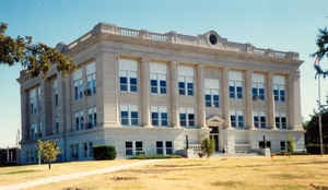
Smith County is a county located in the state of Kansas. Based on the 2010 census, the
population was 3,853. Smith County was created
on February 26, 1867. The county seat is Smith Center.
The county is named for Major J. Nelson Smith, who was part of the 2nd Colorado Cavalry., killed in
action at the Battle of Westport on October 21, 1864.
The geographic center of the contiguous United States is located within the county, near Lebanon.
Etymology - Origin of Smith County Name
The county is named in honor of Major J. Nelson Smith, 2nd Colorado Cavalry, killed in action at the Battle of the Little Blue, October 21,1864.
Demographics:
County QuickFacts: CensusBureau Quick Facts
Smith County History
Smith County, one of the northern tier, is centrally located, east and west. It is bounded on the north by the State of Nebraska; on the east by Jewell county; on the south by Osborne and Rooks, and on the west by Phillips. It was named for Maj. J. Nelson Smith of the Second Colorado cavalry, who was killed at the Battle of the Blue.
The county was organized in 1872, with a population of 3,876, all gained in two years. Cedarville (Cedar) was named as the temporary county seat . At the November election Smith Center was chosen as the county seat.
The geographic center of the 48 contiguous states is located within the county, near the city of Lebanon. The geographic center of North America is located in neighboring Osborne County.
Geography: Land and Water
As reported by the Census Bureau, the county has a total area of 897 square miles (2,320 km2), of which 895 square miles (2,320 km2) is land and 1.5 square miles (3.9 km2) (0.2%) is water.
Smith county is located in north Kansas. The county is prairie with bluffs along the streams. Timber consist of the varieties of wood common to Kansas are found here. Bottom lands average one mile in width and comprise 15 per cent. of the total area. The Solomon River runs through the southern part of the county. Its principal branches are Dry, Spring, Beaver, Cedar and Oak creeks. Magnesian limestone, gray granite and small beds of gypsum are found in different parts of the county.
Neighboring Counties
Bordering counties are as follows:
- Webster County, Nebraska (northeast)
- Jewell County (east)
- Osborne County (south)
- Rooks County (southwest)
- Phillips County (west)
- Franklin County, Nebraska (northwest)
Education
Unified School Districts
Thunder Ridge USD 110
Smith Center USD 237


Click Image to Enlarge
