


Click Image to Enlarge
Kansas Counties
Kansas has one hundred and five counties. Originally 33 counties were organized by the Territorial Legislature in 1855. The Chase County Courthouse in Cottonwood Falls, Kansas was built in 1873 and is the oldest operating courthouse in Kansas. As of January 1, 2009 Greeley County and the city of Tribune unified to form the Unified Government of Greeley County..Thomas County, Kansas
Thomas County Education, Geography, and History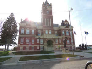
Thomas County is a county located in the state of Kansas. Based on the 2010 census, the county population was 7,900. Thomas County was created on March 20, 1873. The county seat is Colby. The county is named in honor of Major General George Henry Thomas.
Etymology - Origin of Thomas County Name
The county is named in honor of Major General George Henry Thomas (1816-1870), called the 'Rock of Chickamauga' for his defense of that Georgia city in 1863.
Demographics:
County QuickFacts: CensusBureau Quick Facts
Thomas County History
Thomas County, in the northwestern corner of the state, is located in the second tier south of Nebraska and the second east from Colorado. It is bounded on the north by Rawlins county; on the east by Sheridan; on the south by Gove and Logan, and on the west by Sherman. It was created in 1873 and named in honor of George H. Thomas, a major-general of the Civil war. The boundaries were defined as follows: "Commencing at the point where the east line of range 31 west crosses the 1st standard parallel; thence south with said line to the 2nd standard parallel; thence west with said standard parallel to the east line of range 37 west; thence north with said range line to the 1st standard parallel; thence east with said standard parallel to the place of beginning."
Geography: Land and Water
As reported by the Census Bureau, the county has a total area of 1,075 square miles (2,780 km2), of which 1,075 square miles (2,780 km2) is land and 0.1 square miles (0.26 km2) (0.01%) is water.
Thomas county is located in west Kansas. The county is rolling prairie with bluffs and rough lands along the streams. Timber is limited to clumps of cottonwood trees. Sandstone is found in several localities. The Saline river flows east across the southern level of townships. The south fork of the Solomon flows east across the county and the north fork of the same river flows northeast into Sheridan county.
Neighboring Counties
Bordering counties are as follows:
- Rawlins County (north)
- Decatur County (northeast)
- Sheridan County (east)
- Gove County (southeast)
- Logan County (south)
- Sherman County (west)
Education
Unified School Districts
Brewster USD 314
Colby USD 315
Golden Plains USD 316


Click Image to Enlarge
