


Click Image to Enlarge
Kansas Counties
Kansas has one hundred and five counties. Originally 33 counties were organized by the Territorial Legislature in 1855. The Chase County Courthouse in Cottonwood Falls, Kansas was built in 1873 and is the oldest operating courthouse in Kansas. As of January 1, 2009 Greeley County and the city of Tribune unified to form the Unified Government of Greeley County..Wabaunsee County, Kansas
Wabaunsee County Education, Geography, and History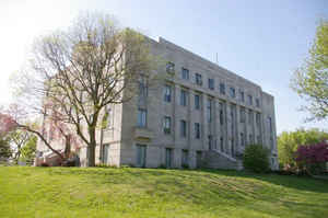
Wabaunsee County is a county located in the state of Kansas. Based on the 2010 census, the county
population
was 7,053. Wabaunsee County was created on August
25, 1855. The county seat is Alma. The
county is named
for a chief of the Potawatomi Indians.
Wabaunsee County is part of the Topeka, KS Metropolitan Statistical Area.
Etymology - Origin of Wabaunsee County Name
The county was created in 1855. Colonel "Dick" Richardson, of Illinois, for whom the county was first named, was the leader in the House of Representatives on the Democratic side in the debate on the Kansas-Nebraska Bill. In February, 1859, the name was changed to Wabaunsee, that being the name of a chief of the Pottawatomie Indians.
Demographics:
County QuickFacts: CensusBureau Quick Facts
Wabaunsee County History
Wabaunsee County, in the eastern part of the state, is located a little north of a central line running east and west and about 75 miles west of the Missouri river, it has an area of 804 square miles; is bounded on the north by Riley county and the Kansas river which separates it from Pottawatomie and Jackson counties; on the east by Shawnee and Osage counties; on the south by Lyon and Morris, and on the west by Morris, Geary and Riley counties. The northern boundary is extremely irregular, following the winding course of the Kansas river, the northeast corner being 6 miles south of the northwest corner. Wabaunsee was one of the 33 counties crested by the first territorial legislature in 1855, and at that time was named Richardson, but as such never had any officers and was attached to Shawnee county for all revenue and judicial purposes. In 1859 the legislature changed the name from Richardson to Wabaunsee in memory of the Pottawatomie chief "Wabonsa," signifying "The Dawn of Day."
Corn is the principal cereal, though winter wheat, potatoes, millet, Kafir corn and alfalfa are raised. The county leads in the production of sweet potatoes and ranks high in live stock. In 1907 there were 70,000 bearing fruit trees.
Geography: Land and Water
As reported by the Census Bureau, the county has a total area of 800 square miles (2,100 km2), of which 794 square miles (2,060 km2) is land and 5.3 square miles (14 km2) (0.7%) is water.
Wabaunsee county is located in east Kansas. The east and west portions of the county are rolling prairie. The central and northern portions are hilly, breaking into bluffs along the streams. Timber consist of walnut, cottonwood, white and burr-oak, mulberry, dog-wood and locust. Thick ledges of limestone lie beneath the whole county. Cement rock of good quality is found near Alma and thin veins of coal have been found throughout the county. The northern and central portions of the county are drained by the Kansas river, which forms the northern boundary, Mill creek and its branches, while the southern and eastern portions are drained by Rock, Elm, Dragon and Mission creeks.
Neighboring Counties
Bordering counties are as follows:
- Pottawatomie County (north)
- Shawnee County (east)
- Osage County (southeast)
- Lyon County (south)
- Morris County (southwest)
- Geary County (west)
- Riley County (northwest)
Education
Unified School Districts
Mill Creek Valley USD 329
Wabaunsee East USD 330


Click Image to Enlarge
