


Click Image to Enlarge
Kentucky Counties
Kentucky has one hundred and twenty counties, third in the US behind Texas's (254) and Georgia's (159.) Washington County was the first county formed in the Commonwealth of Kentucky when it reached statehood, and the sixteenth county formedCrittenden County, Kentucky
Crittenden County Education, Geography, and History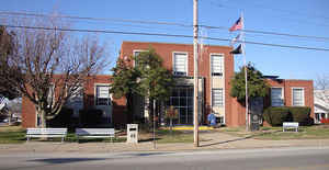
Crittenden County is a county located in the state of Kentucky. Based on the 2010 census, the population was 9,315. The county was created in 1842. The county seat is Marion. Crittenden county is named for John J. Crittenden, senator and future Governor of Kentucky.
Etymology - Origin of Crittenden County Name
The county is named for John J. Crittenden (1787-1863), United States Attorney General; Senator; 15th governor of Kentucky
Demographics:
County QuickFacts: CensusBureau Quick Facts
Crittenden County History
Crittenden County, located on the Ohio and Tradewater Rivers in the Pennyroyal region of Kentucky, was created by the state legislature on April 1, 1842, from a portion of Livingston County. The elevation in the county ranges from 310 to 842 feet above sea level. In 2000 the county population was 9,384 in a land area of 362.14 square miles, an average of 25.9 people per square mile. The county seat is Marion.
Crittenden County was once crossed by the Chickasaw Road, which was a part of the Old Saline Trace. This foot path was used by Native
Americans when hunting game that crossed the Ohio River to the salt licks in Illinois. The first settler in the area was James Armstrong, who
arrived from South Carolina in 1786 and built a log cabin. His family joined him five years later, along with other families that came to
settle in the area. Early in the nineteenth century, Flynn's Ferry was established where the trail crossed the river.
Generally pro-Confederate during the American Civil War, the county saw little fighting, although both armies passed through it repeatedly.
Several skimishes did place there, and the county courthouse was burned by Confederate Brigadier General Hylan B. Lyon during his raid across
western Kentucky in December 1864. Lyon's men, all Kentuckians, burned a total of seven courthouses, since the Union Army was using them for
barracks. The Confederates allowed the locals to remove the records before setting fire to the courthouses.
The county is a prohibition or dry county.
Geography: Land and Water
As reported by the Census Bureau, the county has a total area of 371 square miles (960 km2), of which 360 square miles (930 km2) is land and 11 square miles (28 km2) (3.0%) is water.
Crittenden county is located in west Kentucky. The county's northwestern border with Illinois is formed by the Ohio River. The landscape of Crittenden County is rolling hills.
Neighboring Counties
Bordering counties are as follows:
- Northeast: Union County; Webster County
- Southeast: Caldwell County
- South: Lyon County
- Southwest: Livingston County
- Northwest: Hardin County, Ill.
Education
Students in Crittenden County attend Crittenden County Schools located in Marion.


Click Image to Enlarge
