


Click Image to Enlarge
Kentucky Counties
Kentucky has one hundred and twenty counties, third in the US behind Texas's (254) and Georgia's (159.) Washington County was the first county formed in the Commonwealth of Kentucky when it reached statehood, and the sixteenth county formedGreenup County, Kentucky
Greenup County Education, Geography, and History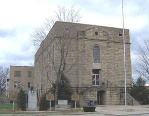
Greenup County is a county located in the state of Kentucky. Based on the 2010 census, the
population was 36,910. The county was created in 1803.
The county seat is Greenup. Greenup
county is named in honor of Christopher Greenup.
Greenup County is part of the Huntington-Ashland, WV-KY-OH Metropolitan Statistical Area (MSA), as well as the Charleston-Huntington-Ashland,
WV-OH-KY Combined Statistical Area.
Etymology - Origin of Greenup County Name
Greenup county is named for Christopher Greenup (1750-1818), Kentucky's 1st congressman, 3rd governor of Kentucky and clerk of the Kentucky Senate.
Demographics:
County QuickFacts: CensusBureau Quick Facts
Greenup County History
Greenup county was formed in 1804. It is located in the Eastern Coal Field region of the state. The elevation in the county ranges from 485 to 1200 feet above sea level. In 2000 the county population was 36,891 in a land area of 346.11 square miles, an average of 106.6 people per square mile. The county seat is Greenup.
Three courthouses have served Greenup County. The first courthouse, built of logs, was replaced by a brick structure in 1811.
Geography: Land and Water
As reported by the Census Bureau, the county has a total area of 354 square miles (920 km2), of which 344 square miles (890 km2) is land
and 10 square miles (26 km2) (2.8%) is water.
Greenup county is located in northeast Kentucky. The county is
mostly made up of rolling hills and valleys. The land in the Ohio River valley
is usually flat and mostly populated by industry, commerce and residential development. Beyond
the Ohio River valley the land gives way to a chain of hills
and valleys. These
hills have popular fishing spots among the Little Sandy River, Greenbo Lake, and Tygarts Creek. Greenup County's land is still
mainly covered by forest with marginal clear cutting of the old forests.
Neighboring Counties
Bordering counties are as follows:
- North: Scioto County, Ohio
- East: Lawrence County, Ohio
- Southeast: Boyd County
- Southwest: Carter County
- West: Lewis County
Education
Public school districts
Greenup County School District serves the cities of Greenup, Wurtland, South Shore and rural Greenup County.
Russell Independent School District serves the cities of Russell, Flatwoods and Bellefonte.
Raceland-Worthington Independent School District serves the cities of Raceland and Worthington.


Click Image to Enlarge
