


Click Image to Enlarge
Kentucky Counties
Kentucky has one hundred and twenty counties, third in the US behind Texas's (254) and Georgia's (159.) Washington County was the first county formed in the Commonwealth of Kentucky when it reached statehood, and the sixteenth county formedKnox County, Kentucky
Knox County Education, Geography, and History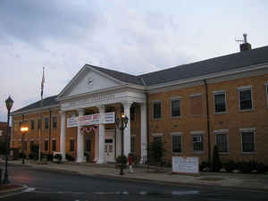
Knox County is a county located near the southeastern corner of the state of Kentucky. Based on the 2010 census, the
population was
31,883. Knox County was created on December 19, 1799.
The county seat is Barbourville. Knox county is
named for General Henry Knox.
Knox County is included in the London, KY Micropolitan Statistical Area.
Etymology - Origin of Knox County Name
Knox county is named for General Henry Knox (1750-1806), officer in the Continental Army and first United States Secretary of War.
Demographics:
County QuickFacts: CensusBureau Quick Facts
Knox County History
Knox County was formed on December 19, 1799, from portions of Lincoln County. It is located in the Eastern Coal Field region of the state. The elevation in the county ranges from 890 to 2322 feet above sea level. In 2000 the county population was 31,795 in a land area of 387.66 square miles, an average of 82.0 people per square mile. The county seat is Barbourville.
The Civil War Battle of Barbourville was fought on September 19, 1861, between 800 Confederate soldiers from General Felix Zollicoffer's
command and 300 Union troops who attempted to defend the Union's Camp Dick Robinson. The Union men tore up the planks on the bridge in an
attempt to keep the Confederates from crossing, but the more numerous Confederates succeeded anyway. They destroyed the camp and seized the
arms and equipment it contained.
The present courthouse, completed in 1964, is the fifth courthouse to serve the county.
Geography: Land and Water
As reported by the Census Bureau, the county has a total area of 388 square miles (1,000 km2), of which 386 square miles (1,000 km2) is land and 1.5 square miles (3.9 km2) (0.4%) is water.
Knox county is located in southeast Kentucky. The Cumberland River flows through this county.
Neighboring Counties
Bordering counties are as follows:
- Northeast: Clay County
- Southeast: Bell County
- Southwest: Whitley County
- Northwest: Laurel County
Education
Three public school districts serve the county:
Knox County Public Schools
Barbourville Independent School District
Corbin Independent School District
Higher education
Union College, a small Methodist-affiliated liberal arts college, is located in Barbourville.


Click Image to Enlarge
