


Click Image to Enlarge
Kentucky Counties
Kentucky has one hundred and twenty counties, third in the US behind Texas's (254) and Georgia's (159.) Washington County was the first county formed in the Commonwealth of Kentucky when it reached statehood, and the sixteenth county formedLincoln County, Kentucky
Lincoln County Education, Geography, and History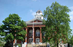
Lincoln County is a county located in the state of Kentucky. Based on the 2010 census, the
population was 24,742. Lincoln County was
created on June 30, 1780. The county
seat is Stanford. Lincoln county is named for General
Benjamin Lincoln
Lincoln County is part of the Danville, KY Micropolitan Statistical Area.
Etymology - Origin of Lincoln County Name
Lincoln county is named for General Benjamin Lincoln (1733-1810), Revolutionary War officer and Secretary of War for the Continental Congress.
Demographics:
County QuickFacts: CensusBureau Quick Facts
Lincoln County History
Organized in 1780, Lincoln was one of the original three counties formed out of Virginia's Kentucky County. (The
other two were Fayette and Jefferson counties.) These three were separated from Virginia to create the Commonwealth of Kentucky in 1792.
It is located in the Southern Knobs region of the state.
The county's original seat was at Harrodsburg, but that part of Lincoln County became Mercer County in 1785. In 2000 the county population was 23,361 in a land area of 336.26
square miles, an average of 69.5 people per square mile. The county seat is Stanford. Lincoln was one of the original
counties in the Kentucky territory of Virginia.
Lincoln is a prohibition or "dry county."
Geography: Land and Water
As reported by the Census Bureau, the county has a total area of 337 square miles (870 km2), of which 334 square miles (870 km2) is land
and 2.5 square miles (6.5 km2) (0.7%) is water.
Lincoln County is located in South Central Kentucky. This county is in the southern part of the ring of Knobs around the Bluegrass region
and includes the
headwaters of the Green River. The elevation in the county ranges from
760 to 1440 feet above sea level.
Neighboring Counties
Bordering counties are as follows:
- Northeast: Garrard County
- Southeast: Rockcastle County
- South: Pulaski County
- Southwest: Casey County
- Northwest: Boyle County
Education


Click Image to Enlarge
