

Click Image to Enlarge
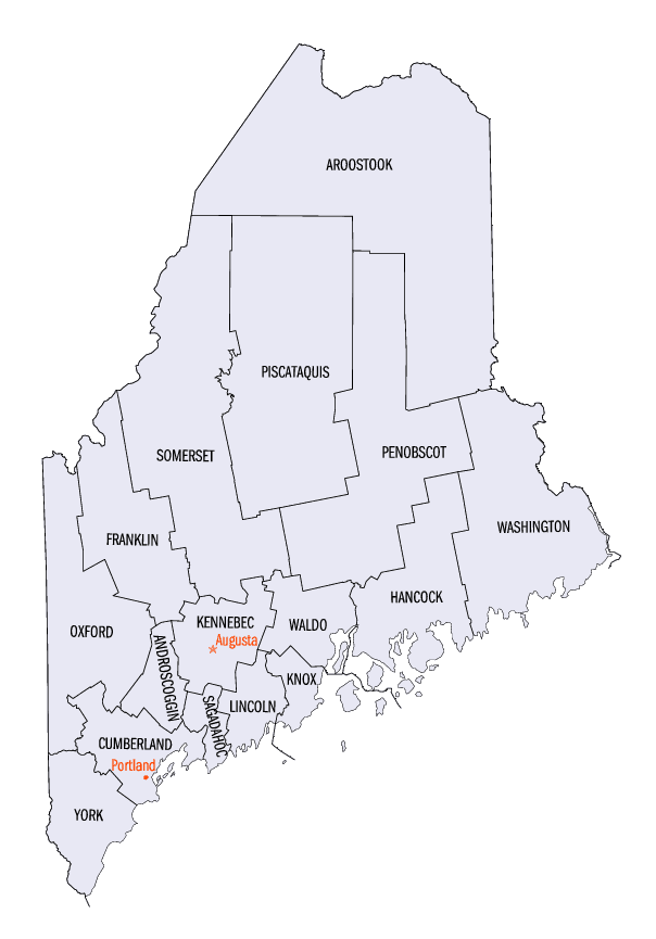
Maine Counties
There are sixteen Counties in Maine. Prior to statehood. The first county to be created was York County, created as York County, Massachusetts by the government of the Massachusetts Bay Colony in 1652. Maine was granted statehood on March 15, 1820 as part of the Missouri Compromise. Nine of the sixteen Counties had their borders defined while Maine was still part of Massachusetts, and hence are older than the state itself. Even after 1820, the exact location of the northern border of Maine was disputed with Britain, until the question was settled and the northern counties took their final, official form by treaty in 1845.Kennebec County, Maine
Kennebec County Education, Geography, and History
Kennebec County is a county located in the state of Maine. Based on the 2010 census, the population was 122,151. Its county seat is
Augusta, the state capital. The county was established on 20 February 1799 from portions of Cumberland and Lincoln Counties. The name Kennebec
comes from the Eastern Abenaki , meaning "large body of still water, large bay".
Kennebec County comprises the Augusta-Waterville, ME Micropolitan Statistical Area.
Etymology - Origin of Kennebec County Name
Kennebec is named for the Kennebec River.
Demographics:
County QuickFacts: CensusBureau Quick Facts
Kennebec County History
History of Kennebec County, Maine
From: A Gazetteer of the State of Maine
By Geo. J. Varney
Published by B. B. Russell, 57 Cornhill,
Boston 1886
Kennebec County occupies the most valuable section of Kennebec River. The surface, though hilly, is not
mountainous. It contains a large number of ponds, and many fine water-powers. The territory is nearly that of the
Kennebec Patent, but it somewhat overpasses the limits of that patent as finally settled. The indefinite description
of those limits caused much litigation, but was finally settled in 1757, by reference to five emineiit lawyers. By
their decision, the southern boundary of the patant placed at the northern line of the town of Woolwich, in the
present county of Sagadahoc, and the northern boundary at what is now the southern line of Cornville, in Somerset
County. Briefly stated, the patent, as settled, covered territory 30 miles wide (15 miles wide on each side of the
Kennebec River), and extended from Merry-meeting Bay to the falls below Norridgewock, and contained 1,500,000 acres.
The tract was valuable in the early period of the country on account of the trade with the natives, and its
fisheries. In 1640, the proprietors of the patent ceded it to the whole body of freemen of Plymouth Colony. Between
1648 and 1653, the colony obtained from the Indian sagamores (leeds of the land extending from Cushnoc (now
Augusta), to the northern limit of the grant, built one or two small forts on the river, and sent magistrates into
the region to protect their rights. Their monopoly was often intruded upon, and caused them so much annoyance that
in 1661 they sold their entire right in the patent for ?400 sterling to four men, Antipas Boies, Edward Tyng, Thomas
Brattle and John Winslow.
The settlement of the river was very slow, so that in 1675, when the first Indian war broke out, there were scarcely
100 persons residing on or near the river. In 1676 the buildings northward of Swan Island were all destroyed, and
the inhabitants driven away. Under an act passed by General Court in 1753, a new corporation was formed with the
name of "The Proprietors of Kennebec Purchase from the late Colony of New Plymouth,"which was usually contracted to
"Plymouth Company"in actual use. In 1818, the corporation, having disposed of all its interest in time territory,
ceased to exist.
he Kennebec River, when first visited by the English, was occupied by a powerful tribe of Indians called Canibas. It
numbered about 1,500 warriors at this time. Their various villages formed subtribes, all of which acknowledged
allegiance to the great chief, Kennebis, who resided on Swan Island, opposite what is now the town of Richmond. The
chief villages were Norridgewock, Taconet (at Waterville) and Cushnoc (Augusta). Sebastian Rasle, a Roman Catholic
missionary, resided at Norridgewock for many years, exercised a powerful influence over the whole tribe.
The first trading-posts on the Kennebec were established at Augusta and Richmond in 1629, the same year that the
patent was obtained by the New Plymouth proprietors. In 1754, in order to give security to the settlements in the
region, the Plymouth Company built Fort Western at Cushnoc by agreemtieimt with the government of Massachusetts,
which built in the same and following year Fort Halifax, in what is now the town of Winslow, and Fort Shirley in
Dresden, opposite the other end of Swan Island. At about the same time, Dr. Sylvester Gardiner, agent of the
Plymouth Company, made his residence on the Kennebec, the better to effect settlements. Soon after the above date he
erected two saw-mills, a grist-mill and a fulling-mill, a wharf, stores and dwelling-houses in the town which now
bears his name. Time downfall of the French power in the north brought security to the settlements of Maine, and
those on the Kennebec soon greatly increased.
In 1760 two counties called Cumberland and Lincoln were organized from old York County. Lincoln County at that time
included the territory of the Kennebec Patent, and the proprietory company erected buildings for the new county at
Pownalborough, now Dresden. The old court-house has been changed into a dwelling-house, and is still in a good state
of preservation. In 1799 the northern part of Lincoln County was erected into a new county by the name of Kennebec,
with Augusta as the shire town. In 1809, Somerset County was organized, by which Kennebec County lost nearly
four-fifths of its territory. Waldo County, formed in 1827, took from it four towns,- Unity, Freedom, Joy and
Burnham. By the organization of Franklin County in 1838, Kennebec lost the towns of New Sharon, Chesterville,
Wilton, Temple and Farmington; and at the incorporaton of Androscoggin County, the towns of East Livermore, Greene,
Leeds, and Wales, were dissevered from the County of the Kennebec. It is now made up of 24 towns and 3 cities. The
last are Augusta, Hallowell and Gardiner, situated upon the Kennebec, the first and last only 6 miles apart, and.
the second between them.
In 1787, Hallowell (then including Augusta), was made a halfshiretown with Pownalborough, the session being held at
Fort Western. The judges were William Lithgow, James Howard and Nathaniel Thwing. In 1788, William Lithgow, jr.,
opened an office at Fort Western settlement, and was therefore the first lawyer resident in what is now Kennebac
County. The first court-house was built in Augusta (then a part of Hallowell), in 1790, and stood in Market Square.
In 1801, Kennebec County having been incorporated and Augusta set off from Hallowell, a new court-house was begun on
the site of the present jail. In 1827, the present granite court-house was erected. A jail of wood was erected in
1793, but was burned in 1808. Another built at that time remained in use until 1859. In the latter year was
completed a new jail of granite, iron and brick, at a cost of over $50,000. It is considered to be the finest
building in the city, and the finest and most substantial building for its purpose in time State.
Kennebec, though one of the smallest counties in area, is one of time best, and at present the very best
agricultural county in the State. The soil along time river on both sides is, to a great extent, of clay loam, and
easily cultivated and productive; and probably a larger crop of hay is harvested in the river towns of this county
than in any other equal area in New England. The underlying rock is chiefly granite, and quarries of fine quality
are operated in Hallowell. The ice busiimess is also an important industry; amd probably no section of equal extent
in the world yields a larger supply, or a superior quality, of this very useful article.
Kennebec County has several agricultural societies, all in a flourishing condition. It has three hundred and
forty-nine schoolhouses, valued at $243,781,. Its real estate in 1870 was valued at $21,004,034. In 1880 it was
$23,292,164. The population at the same date was 53,203. In 1880 it was 52,061; of these 26,423 are male and 26,638
females. The natives number 49,565, and foreign born 3,496. There are 123 colored inhabitants...Kennebec
County
Geography
As reported by the Census Bureau, the county has a total area of 951 square miles (2,464 km2), of which, 868
square miles (2,247 km2) of it is land and 84 square miles (217 km2) of it (8.79%) is water.
Neighboring Counties
Bordering counties are as follows:
- Somerset County, Maine - north
- Waldo County, Maine - east
- Sagadahoc County, Maine - south
- Lincoln County, Maine - south
- Androscoggin County, Maine - southwest
- Franklin County, Maine - northwest
Education
There are three colleges: Colby College and Thomas College (both in Waterville), and the University of Maine at Augusta. There are 19 school districts (however, 4 are consolidated ones). In China Maine, there is no public high school, but a private school (Erskine Academy) exists, and the town pays for students tuition if they choose to attend. Students from Vassalboro can pick from one of four school districts (Cony in Augusta, Erskine, Winslow, or Waterville). However, many towns have local public high schools.


Click Image to Enlarge
