

Click Image to Enlarge
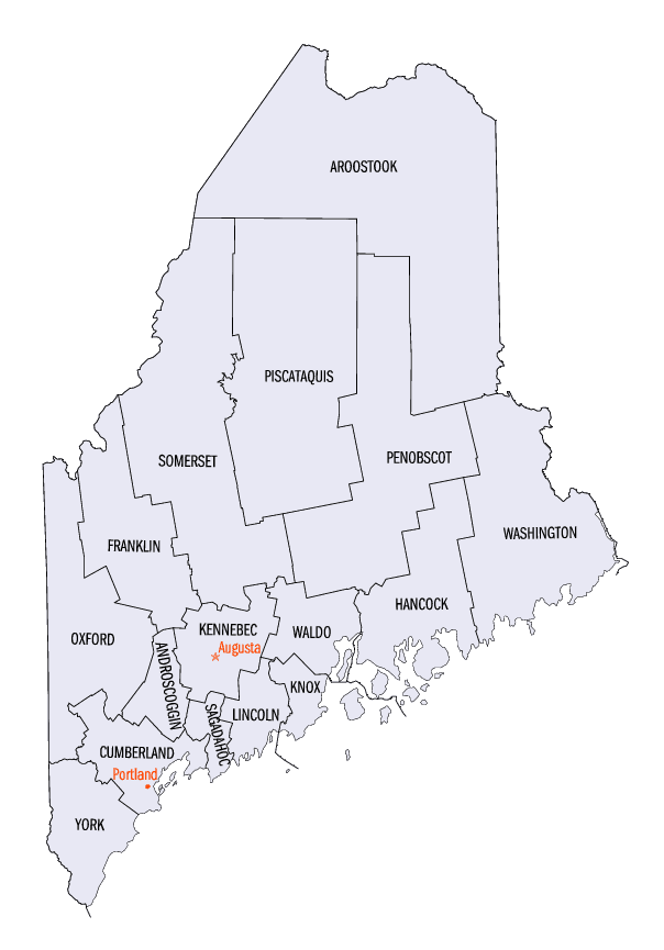
Maine Counties
There are sixteen Counties in Maine. Prior to statehood. The first county to be created was York County, created as York County, Massachusetts by the government of the Massachusetts Bay Colony in 1652. Maine was granted statehood on March 15, 1820 as part of the Missouri Compromise. Nine of the sixteen Counties had their borders defined while Maine was still part of Massachusetts, and hence are older than the state itself. Even after 1820, the exact location of the northern border of Maine was disputed with Britain, until the question was settled and the northern counties took their final, official form by treaty in 1845.Knox County, Maine
Knox County Education, Geography, and History
Knox County is a county located in the state of Maine. Based on the 2010 census, the population was 39,736. Its county seat is Rockland. The county is named for American Revolutionary War general and Secretary of War Henry Knox, who lived in the county from 1795 until his death in 1806. The county was established on April 1, 1860, and is the most recent county to be created in Maine. It was carved from parts of Waldo and Lincoln counties.
Etymology - Origin of Knox County Name
Knox is named for Henry Knox, the first United States Secretary of War who lived in Thomaston, Maine.
Demographics:
County QuickFacts: CensusBureau Quick Facts
Knox County History
History of Knox County, Maine
From: A Gazetteer of the State of Maine
By Geo. J. Varney
Published by B. B. Russell, 57 Cornhill,
Boston 1886
Knox County is situated on the south-eastern side of Penobscot Bay, and includes its islands south of Isleboro,
and west of Isle au Haut Bay. It was organized in 1860, being formed from Lincoln and Waldo, and named for General
Knox, the friend of Washington, who was a resident of the county during the later years of his life. It contains
thirteen towns, one city, and two organized plantations, viz.: Appleton, Camden, Cushing, Friendship, Hope,
Hurricane Isle, North Haven, City of Rockland, St. George, South Thomaston, Thom aston, Union, Vanalhaven Warren,
Washington, Matinicus Isle Plantation, and Muscle Ridge Plantation. Rockland is the shire town. The St. George's
River runs through the county in a general south course, dividing it into two nearly equal sections. On this stream
and its branches, the outlets of a large number of ponds, are many waterpowers. The principal elevations of land are
the Camden Hills, extending from Thomaston through the western part of Rockland to the Penobscot on the
north-eastern side of Camden. Of these, Mount Megunticook is 1,265 feet high; Ragged Mountain, 1,230; Mount
Pleasant, probably about the same height as the latter; Bald Mountain, 1,140 feet; and Mount Battie, nearly 1,000
feet. Mount Hatchet, in Hope is a considerable eminence, and another in Rockland, 558 feet in height, is known as
Madambettox, Mathabesec, and also as Dodge's and Marsh's Mountain. The soil compares well with that of other
counties, being generally fertile in the valleys and on the interior slopes, and sterile on the ridges and along the
coast. St. George's and its neighborhood was one of the earliest points visited and occupied by Europeans. In 1630,
Leverett and Beauchamp, two English merchants, received by grant from the Plymouth Company, the territory lying
between the Penobscot and Muscongus Rivers, extending north far enough to form a tract 30 miles square, or nearly
600,000 acres. This was first known as the Muscongus, and, subsequently, the Waldo patent, from having passed into
the ownership of that family. This patent forms the basis of most of the land titles in Kirnx and Waldo counties. In
1694, Sir William Phips acquired a partial title to lands in the southern part of Knox County, by purchase from
Madockawando, a famous chief of the Tarratines. The two block-houses which, by subsequent enlargements, became Fort
St. George, were erected in 1719- 1720.
Lovewell's, or the "Three Years' War"with the Indians began in 1722 and continued into 1725. During this time the
inhabitants of Knox County suffered greatly; and in July of this year two Massachusetts commissioners held a
conference at the fort with thirteen Indian chiefs. This was adjourned to Boston, where for a month the discussion
of the differences between them and the settlers in this region were discussed by the State authorities and two
chiefs representing the tribe; the Indians denying Madockawando's right to make a sale of land here as he had to
Governor Phips. At length the chiefs were pacified by an agreement to establish trading-houses on the St. George's,
where goods should be sold to the Indians at a slight advance on cost. This arrangement was known as the Dummer
Treaty, and was ratified in the following summer by a large concourse of Indians at what is now Portland.
It was at this epoch that we first hear of Samuel Waldo, a young Boston merchant, who, about this time, by
inheritance and by subsequent purchase came into possession of nearly the whole of the Muscongus patent, all, in
fact, of Knox and Waldo counties, except what is now included in the towns of Camden, Hope and Appleton. Thus Mr.
Waldo became sole patentee of half a million acres, whose northern boundary was claimed by him to be but very little
south of the site of Bangor. One of his first acts was to open the lime-quarry which was long afterward enclosed by
the walls of the Maine State Prison, where he commenced the manufacture of lime for the Boston market,- thus being
the pioneer of what has become a leading industry in the region. In 1735, Mr. Waldo contracted to deed to each
settler a lot 40 rods wide on the River St. George, and running back so as to contain 100 acres; the settlers on
their part agreeing to build houses, and clear four acres of land on the lots occupied within two years. The first
party consisted of 27 families of Scotch-Irish extraction.
Among the names of these were Patterson, Boggs, Creighton, Starrett, Spear, Lermond, McIntyre, Robinson, and Kallock,- still
represented in these towns. Mr. Waldo in the same year rebuilt the saw-mill at Mill River; in 1740, he erected a
grist-mill at Oyster River, and erected a house for religious meetings. About this time he also located 40 lots on
the western side of the river, on what is now Cushing, about 30 of which were at once occupied. In 1743 a settlement
was effected in what is now Friendship (then Meduncook), by several families of English Puritan extraction. In 1744,
an Indian war again visited the eastern regions, and the inhabitants again endured the horrors of savage warfare. In
1745 occurred the famous expedition which resulted in the capture of Louisburg. In the laud force Waldo, who had
some time previously become a militia colonel, bore the rank of Brigadier General. With the return of peace,
prosperity again smiled upon the settlement. In 1753, General Waldo settled another colony of twenty Scottish
families some two miles from the river on the western side. Anderson, Dicke, Crawford, Malcolm and Kirkpatrick are
the names of some of them. They called their settlement Stirling, and the name still adheres to the locality. Again
from 1754 to 1758 an Indian war raged in Maine, to the great distress of the St. George's settlers. With the fall of
the French power in the north, the Indians realized that they could no longer contend with the English, and in the
treaty with them which closed this war they acknowledged they had forfeited their lands, and all contention ceased.
General Waldo died in 1759, and the larger part of this patent came into the hands of his son-in-law, Thomas Flucker,
of Boston.
At the breaking out of the Revolution, the inhabitants of this region were generally found on the patriot side. All
signed the "Solemn League and Covenant"binding to non-intercourse with Great Britain until the Boston Port Bill
should be repealed; and in June, 1775, they formed a Committee of Safety and Correspondence. After the failure of
the expedition against the British at Castine in 1779, General Peleg Wadsworth, the second in command of the land
forces, bad his headquarters as commander of the Eastern Department at Thomaston. It happened by the expiration of
enlistments that he was at one time left with only a body-guard of six men, when his house was attacked in the night
by twenty-five British soldiers from Castine. After brave resistance the General was wounded and carried as prisoner
to the British garrison at Castine. After being for some months in confinement there, he together with a companion
in misfortune- Majcr Benjamin Burton - escaped during a severe thunder storm; and, crossing the Penobscot, quickly
found safety among their countrymen.
At the close of the war, there was much uncertainty in regard to land titles. Thomas Flucker, the heir of General
Waldo, had espoused the cause of the king, and was theiefore included in the act of proscription. In a few years,
such portion of the patent as had not been disposed of, came into the possession of Flucker's son in law, General
Henry Knox. On resigning his commission as secretary of war in 1195, he removed to the mansion he had prepared in
Thomaston. The mansion, to which Mrs. Knox had given the name, Montpelier, was opened with a grand feast, to which
were invited all the neighboring inhabitants- rich and poor; and here he continued for the remainder of his life to
dispense the most bountiful hospitality. Among his distinguished guests were Talleyrand and Louis Phitippe. General
Knox entered upon the development of his estate with energy. lie commenced the manufacture of lime, erected mills,
introduced new varieties of fruits and vegetables, and improved breeds of cattle and sheep. His extensive operations
brought in many new settlers; but his expensive establishment drew heavily on his income, and an ardent temperament
sometimes involved him in unprofitable schemes, so that the great estate was after his death found to be insolvent.
He died suddenly in 1805; and his remains now rest in the cemetery at Thomaston. In the war of 1812, the chief
interest centred in the privateering on the coast and the importation of foreign goods in neutral vessels,- which
having run the British blockade were transported across the country to Boston by ox-teams. In the war of the
Rebellion, Knox County sustained her credit for patriotism and bravery. Major General Hiram G. Berry, who fell at
Chancellorsville, was the most eminent among her sons in this period of our history.
By the census of 1880, the amount of shipping owned in Knox County was 84,931 tons, having a value of $1,660,584.
The amount of personal estate was $4,032,582; and of real estate $6,846,154. The population in 1870 was 30,823; and
1880, 32,862...Knox County
Geography: Land and Water
As reported by the Census Bureau, the county has a total area of 1,142 square miles (2,958 km2), of which, 366
square miles (947 km2) of it is land and 776 square miles (2,011 km2) of it (67.98%) is water. It was originally
part of the Waldo Patent.
Neighboring Counties
Bordering counties are as follows:
- Waldo County, Maine - north
- Lincoln County, Maine - west
Education


Click Image to Enlarge
