

Click Image to Enlarge
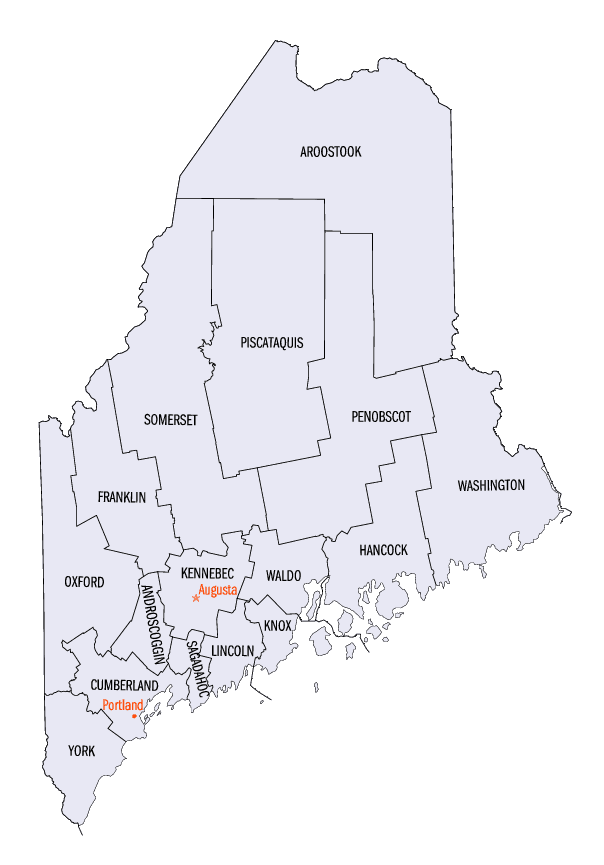
Maine Counties
There are sixteen Counties in Maine. Prior to statehood. The first county to be created was York County, created as York County, Massachusetts by the government of the Massachusetts Bay Colony in 1652. Maine was granted statehood on March 15, 1820 as part of the Missouri Compromise. Nine of the sixteen Counties had their borders defined while Maine was still part of Massachusetts, and hence are older than the state itself. Even after 1820, the exact location of the northern border of Maine was disputed with Britain, until the question was settled and the northern counties took their final, official form by treaty in 1845.Lincoln County, Maine
Lincoln County Education, Geography, and History
Lincoln County is a county located in the state of Maine. Based on the 2010 census, the population was 34,457. Its county seat is
Wiscasset. The county was founded in 1760 from a portion of York County, Massachusetts and named after the English city Lincoln, the
birthplace of Massachusetts Bay Provincial Governor Thomas Pownall.
At its founding, Lincoln County accounted for three-fifths of the state's land, and stretched east to Nova Scotia. Thirteen counties were
cut out of this land including Sagadahoc County to the west. The county flag is a traditional New England flag, adopted in 1977
Etymology - Origin of County Name
Lincoln is named for the city of Lincoln, England.
Demographics:
County QuickFacts: CensusBureau Quick Facts
Lincoln County History
History of Lincoln County, Maine
From: A Gazetteer of the State of Maine
By Geo. J. Varney
Published by B. B. Russell, 57 Cornhill,
Boston 1886
Lincoln County occupies a middle place on the coast of Maine in respect to population, and no county of equal
territory has so many harbors and havens. It is much cut up by arms of the sea and pond-like rivers, but there are
no great variations of altitude in the surface. Damariscotta River occupies nearly the middle line of the county,
extending from north to south. East of this and parallel thereto is the line of Muscongus Bay, its extension inland
as Broad Bay, and Medomac River. Parallel on the west is the Sheepseot River, with its excellent harbor. This county
is bounded on the east by Knox County, west by Sagadahoc and Kennebec, and north by the last, Waldo and Knox, and
south by the ocean The Knox & Lin. r.r. crosses it.
Lincoln County was established in 1760, at the same time with Cumberland County. The easterly line of Cumberland was
then the westerly line of Lincoln. "From the time of its formation until the erection of Hancock and Washington
Counties in 1789, Lincoln extended over quite three-fifths of the territory of the province."Its westerly line was
'from Small Point north-westerly upon Casco Bay to New Meadows River, and up said river to Steven's carrying place
at the head of said river, and up said river 30 miles ; then north two degrees west on a true course to the utmost
limit of the province.' Its north was Canada, its east Nova Scotia, and its south the ocean. Hancock County came
across Penobseot Bay and river, and took in nearly the whole of the Waldo patent. In 1799, the organization of
Kennebec took four-fifths of what. remained after the formation of Hancock. Lincoln then continued undisturbed until
1827, when it parted with six towns to form Waldo; and it had an equal run of time again, down to the organization
of Androscoggin and Sagadahoc, in 1854, when the former received three towns from it, and the latter was made
entirely from it."In 1860 (the centennial of Lincoln County), Knox County was organized, taking from her nine more
towns, leaving the arent county with but 17 towns and a plantation to her name. In still earlier time this region
had been claimed by France as a part of her territory of Acadie; later, it was known as Sagadahoc Territory; and in
1665, the Duke of York (subsequently James II.), to whom it had been granted by the King, erected it into the County
of Cornwall,- Jamestown, at Pemaquid, being the capital, and New Dartmouth (Newcastle), a shire town.
At the outbreak of King Philip's war, in 1675, the settlements of Cornwall, scattered over a wide extent of country,
embraced some 300 families. Under the prudent management of Abraham Shurt, the chief magistrate of this county, a
larger degree of amity had been maintained with the Indians than in other parts ; and the inhabitants of this region
did not suffer so severely during the first year of the war as those in the westerly settlements. In the second
year, however, Old Cornwall was likewise swept with the besom of destruction; and thenceforth until 1700 the
settlements were deserted, or the inhabitants who remained were in terror of savage attacks, with only brief
intervals of repose. In 1688, the County of Cornwall was entirely depopulated and desolated by the Indians under the
lead of Moxus. Sir William Phips, first governor of Massachusetts under William and Mary, was desirous of doing
something, if possible, to recover from the dominion of the savage the land of his youth; and in 1692 he built in
place of Fort Charles, which had been destroyed, a fortification of stone, naming it Fort William Henry. In 1696, M.
Iberville, with a force of French and Indians, entered the harbor and invested the place, and by means of artillery
succeeded in forcing its surrender.
It was not until 1729 that the permanent re-peopling of Old Cornwall commenced. At this time Col. David Dunbar, who
had been commissioned surveyor-general of the King's woods, and deputy-governor in the eastern parts of New England,
repaired Fort William Henry, also re-naming it Fort Frederick. He set vigorously at work to settle the county. To
actual settlers he made grants of a homestead of 10 or 12 acres, and 100 acres of farm land. The settlers brought in
by Colonel Dunbar were largely Protestant English, with some Scotch and Irish Presbyterians; and by his aid the
Presbyterian church became established as the prevailing phase of religion in this county until after the
Revolution.
At the same time with the formation of the county, was incorporated Pownalboro', its shire town, which was named for
Thomas Pownal- at that date governor of Massachusetts. His birth-place was Lincoln, England, a city famous for its
antiquity and its noble cathedral; and thus Governor Pownal appears to have been further complimented in the name of
the new county.
Lincoln County has 180 public schoolhouses, and her school property at the close of 1879 was valued at $89,250. The
valuation of the county in 1870 was $6,857,610. In 1880 it was $6,634,693. The population in 1870 was 25,597. In
1880 it was 24,809...Lincoln County
Geography: Land and Water
As reported by the Census Bureau, the county has a total area of 700 square miles (1,812 km2),
of which, 456 square miles (1,181 km2) of it is land and 244 square miles (631 km2) of it (34.84%) is water.
Neighboring Counties
Bordering counties are as follows:
- Kennebec County, Maine - north
- Waldo County, Maine - northeast
- Knox County, Maine - east
- Sagadahoc County, Maine - west
Education


Click Image to Enlarge
