

Click Image to Enlarge
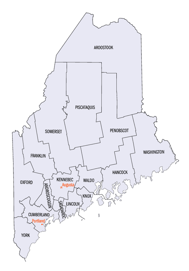
Maine Counties
There are sixteen Counties in Maine. Prior to statehood. The first county to be created was York County, created as York County, Massachusetts by the government of the Massachusetts Bay Colony in 1652. Maine was granted statehood on March 15, 1820 as part of the Missouri Compromise. Nine of the sixteen Counties had their borders defined while Maine was still part of Massachusetts, and hence are older than the state itself. Even after 1820, the exact location of the northern border of Maine was disputed with Britain, until the question was settled and the northern counties took their final, official form by treaty in 1845.Oxford County, Maine
Oxford County Education, Geography, and History
Oxford County is a county located in the state of Maine. Based on the 2010 census, the county had a population of 57,833. Its county seat
is Paris. The county was formed on March 4, 1805 from northerly portions of York and Cumberland counties. Its Canadian border is the province
of Quebec.
Part of Oxford County is included in the Lewiston-Auburn, Maine metropolitan New England City and Town Area while a different part of Oxford
County is included in the Portland-South Portland-Biddeford, Maine metropolitan New England City and Town Area.
Etymology - Origin of Oxford County Name
Oxford is probably named for Oxford, Massachusetts.
Demographics:
County QuickFacts: CensusBureau Quick Facts
Oxford County History
History of Oxford County, Maine
From: A Gazetteer of the State of Maine
By Geo. J. Varney
Published by B. B. Russell, 57 Cornhill,
Boston 1886
Oxford County occupies about two-thirds of our New England border, having a length of about 100 miles. Lying in near
neighborhood with the White Hills of New Hampshire, Oxford County is emphatically the hill-region of Maine. Though it
does not contain the highest eminences in the State, it presents more lofty peaks than any other equal extent of
territory in New England. Among the most noted we should mention Mount Pleasant in Denmark, about 2,000 feet in height,
and peculiar in its isolation, Speckled Mountain in Trafton and Streaked Mountain in Buckfield, striking in their
appearance; and Mount Mica in Paris, noted for the variety and beauty of its minerals. Granite, largely in the form of
gneiss, underlies most of the county. Silver, gold, lead, zinc, arsenic, plumbago and iron are found in various places,
also many varieties of valuable minerals. Tokens of former extensive action of water is shown everywhere in the
excavation of valleys and the deposit of drift, while the bed rock, when uncovered, often exhibits glacial or drift
markings. The soil in general is a gravelly loam, resting usually upon a solid bed of coarse gravel called "pan." It is
generally productive. Along the streams are many broad tracts of interval, with a soil of mingled vegetable and mineral
matter, formed by the overflow waters in spring and autumn. The great pinetrees, which were formerly numerous in all
parts of the county, have been largely cut off, but there still remain, especially in northern and western parts, heavy
growths of spruce, hemlock, rock-maple, beech and birch. The scenery of Oxford County is unsurpassed of its kind. Lofty
and snowclad peaks, with almost impassable glens between, have their peculiar and thrilling attraction; but the peaceful
verdure of great woods, grassy valleys, rich meadows, hillsides enlivened with flocks and herds, shining streams, and
sky-repeating ponds, with occasional breeze-swept eminences, affording wide views of the surrounding beauties, hold the
regard of the lover of nature for a longer time, and are more restorative in their influences.
Oxford County contains the larger portion of the lakes which form the source of the Androscoggin River, which also runs
for nearly onethird of its length through the midst of the county. In the central portion of the county lie the ponds
from which the Little Androscoggin takes its rise. By numerous turnings and windings, the beautiful Saco River confers
on this county, in its southern portion, about one half its length.
The Androscoggin Lakes, lying in unsettled territory in this and adjacent divisions, can best be noticed in this
connection. The aggregate area of these lakes is nearly 80 square miles. They lie on the western part of the great
elevated plateau of Maine. Their altitude above the sea is as follows : -Rangely, 1,511 feet; Mooselucmaguntic, 1,486;
Richardson, 1,456; Umbagog, 1,256. Jataska, at the extreme head-waters of the Mississippi River, has an elevation of
only 64 feet more than Rangely, 75 miles from the sea. Rangely Lake, the first large body of water in this series, lies
wholly in Franklin County, and has been partially described in the article on the town of Rangely. We may mention here,
however, that this lake is some 10 miles from one extreme to the other, and about 1 3/4 miles in extreme width, with an
area of 14 square miles. Rangely has its name from an English gentleman who for several years resided with his family in
the seclusion of its northern shore. The Indian name was Oquossoc, perpetuated in the name of an angling association, by
one of their camps, a hotel, and a steamer that plies upon these lakes. Cupsuptic Lake, at the north-west of Rangely,
and separated from it only by Bald Mountain and a narrow isthmus at its base, has an area of 3 square miles. On this
lake where it rcceives the waters of Rangely Lake, is "Indian Rock." Cupsuptic River. the principal feeder of this lake,
has its source in Canadian soil. Great Lake or Mooselucmaguntic, lying south of the last, and south-west of Rangely, is
the largest of this chain of lakes. It is about 9 miles in length, and about 3? in the broadest part and 1? in the
narrowest. Its area is 21 square miles. On its outlet, the Richardson Lake Dam Company have their "Upper Dam," the
"Lower Dair "being on the outlet of Lower Richardson Lake. This dani is situated about midway of the rapid stream
between the lakes, and is a vast and ponderous rampart of wood and iron, whose purpose is to hold back the waters of the
upper lakes, in order to control the supply for manufacturing purposes. The ownership of the water privilege of these
lakes is in the Union Water Power Company, at Lewiston. Next, at the outlet of Great Lake, about 2 miles to the
south-west, is Upper Richardson, or Molechunkeinunk Lake, having a length of some 5 miles and a breadth varying from 2
to 3 miles, with an area of 10 square miles. Still south-west of this and connected by a broad, quiet stream, is the
lower Richardson. or Welokenabacook Lake. This is a little larger in each direction than Upper Richardson, and has an
area of 11.15 square miles. On its outlet is the Middle Dam. It discharges into Umbagog Lake, on the line between Maine
and New Hampshire, which is the last in this series of lakes. Its length is nearly 11 miles, its greatest width about
3?, and its least, 1? miles. Its area is 18 square niiles. About a mile west of the lake its outlet receives the waters
of Megalloway River, and here the stream of the Androscoggin is fully formed. About 3 miles below this junction is Errol
Dam, the lowest landing-place of the lake steamers.
The Megallowa.y has its rise in Parmachene Lake, some 25 miles north of Umbagog. An interesting locality on these lakes
is "Indian Rock," which has long been a well-known fishing-place and camp. A national post-office is now established
here under the name. A short distance up the stream is Indian Eddy, and just below it on the opposite side, sparkling
Kennebago River comes in. Almost in view from the outlet are Kennebago Falls; and in the space between the mouth and
Cupsuptic Lake, is located Camp Kennebago, with a hotel and all necessary appurtenances. This establishment is the
property of the Oquossoc Angling Association. The course of the Kennebago is dotted with ponds, one of which is
Kennebago Lake, some 15 miles from Rangely. This river has its rise a few miles east of the southernmost point of the
British Dominion on this side of Maine, in a group of seven ponds lying near each other. At the extremity of the
southern area of Lower Richardson Lake is McAlister's Camp and the steamboat wharf for this part of the lake,-connecting
with a carriage road to Andover Corner, distant about 15 miles.
The Indians of Oxford County were all of the Abenaki nation. They were the Anasagunticooks and the Sokokis tribes. The
first was a powerful tribe who occupied the entire valley of the Androscoggin to Merrymeeting Bay, and were quite fierce
and warlike. The Sokokis are regarded as the most ancient tribe in Maine. The clan or branch, which dwelt in Oxford
County was known under the name of Pequakets.
Soon after the downfall of the French power in the north relieved the inhabitants of the northern border from the fear
of Indian wars, attention turned more strongly to the lands of Maine. In 1762 a township of land on Saco River was
granted to Gen. Joseph Frye, a native of Andover, Mass., and a distinguished soldier during the French and Indian wars.
This was the first grant made within the limits of Oxford County, and received the name of Fryeburg. Its settlement
began the following year. Other grants followed, and settlements were made in Waterford, Bethel, Rumford, raris, Hebron,
Buckfield, and others in succession. The territory now embraced by the county of Oxford was originally embraced in York,
as, in fact, was also the whole of Maine. In 1760 Cumberland County was formed, embracing the whole of the present
Oxford, with the exception of a few western towns. Oxford County was formed by an act approved March 4, 1805, from
portion of York and Cumberland, Paris being fixed upon in the act as the shire town. The southern tier of towns in the
county, were Turner, Hebron, Norway, Waterford, Lovell, Denmark, Hiram and Porter, and included all the territory north
of these towns, between New Hampshire on the west and Kennebec County on the east, to Canada. In 1838 the county of
Franklin received five towns and a large number of plantations from Oxford, constituting more than half its territory.
In 1854 it relinquahed two towns to form Androscoggin County. It now has 35 towns and 3 organized plantations. Its area
is about 1700 square miles.
The Grand Trunk Railway was extended through the county in 1850; previous to which time the people were accommodated by
a stage-line to Portland, which made trips each way twice a week, and farmers carried their produce to Portland with
their teams. The Rumford Falls and Buckfield Railroad connects with the Grand Trunk at Mechanic Falls, but at present
has not been built beyond Canton Point. Below Mechanic Falls, the Lewiston and Auburn Railroad connects, forming a
branch to Lewiston.
Oxford County has two agricultural societies, both in a prosperous condition. They are the Oxford County society, its
grounds lying between Norway and South Paris villages, West Oxford having its fair ground at Fryeburg. The East Oxford
society is now extinct. This county has 350 public school-houses; and the school property is valued at $117,000. The
population in 1870 was 33,488. In 1880 it was 32,625. The valuation of estates in 1870 was $9,794,066. In 1880 it was
$10,058,554....Oxford County
Geography: Land and Water
As reported by the Census Bureau, the county has a total area of 2,175 square miles (5,634 km2), of which,
2,078 square miles (5,382 km2) of it is land and 97 square miles (252 km2) of it (4.47%) is water.
Neighboring Counties
Bordering counties are as follows:
- Franklin County, Maine - northeast
- Androscoggin County, Maine - east
- Cumberland County, Maine - southeast
- York County, Maine - south
- Carroll County, New Hampshire - southwest
- Coos County, New Hampshire - west
Education


Click Image to Enlarge
