

Click Image to Enlarge
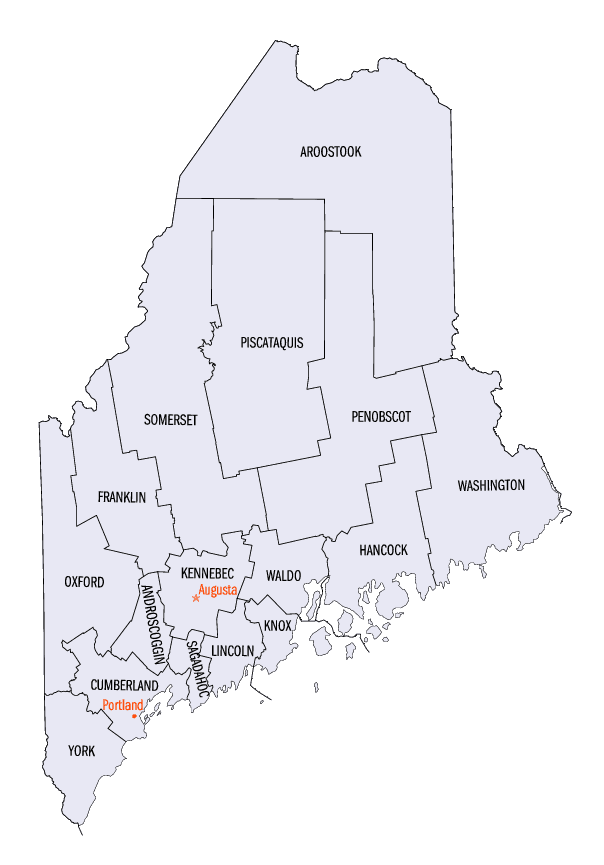
Maine Counties
There are sixteen Counties in Maine. Prior to statehood. The first county to be created was York County, created as York County, Massachusetts by the government of the Massachusetts Bay Colony in 1652. Maine was granted statehood on March 15, 1820 as part of the Missouri Compromise. Nine of the sixteen Counties had their borders defined while Maine was still part of Massachusetts, and hence are older than the state itself. Even after 1820, the exact location of the northern border of Maine was disputed with Britain, until the question was settled and the northern counties took their final, official form by treaty in 1845.Piscataquis County, Maine
Piscataquis County Education, Geography, and History
Piscataquis County is a county located in the state of Maine. Based on the 2010 census, its population was 17,535, making it Maine's least-populous county. Its county seat is Dover-Foxcroft. The county was incorporated on 23 March 1838, taken from the western part of Penobscot County and the eastern part of Somerset County, and is named for an Abenaki word meaning "branch of the river" or "at the river branch."
Etymology - Origin of Piscataquis County Name
Piscataquis is named for an Abenaki word meaning rapid waters.
Demographics:
County QuickFacts: CensusBureau Quick Facts
Piscataquis County History
History of Piscataquis County, Maine
From: A Gazetteer of the State of Maine
By Geo. J. Varney
Published by B. B. Russell, 57 Cornhill,
Boston 1886
Piscataquis County is the central region of Maine. Penobscot County bounds it on the east and south, Somerset on the
west and south, and Aroostook on the north and east. On the western boundary lies Moosehead Lake, and opposite, on
the eastern side, are Peinadumcook and Millinoket lakes. This county also constitutes a large part of the most
elevated region of Maine, lying, on an average upwards of 1200 feet above the sea. Midway of its eastern border
rises Katahdin to a height of 5,385 feet above sea level. Several others rise many hundreds of feet above the
surrounding region, and to thousands of feet above the sea. The greatest height of land appears to be about midway
between Moosehead Lake on the west and Pemadumcook on the east, Chesuncook on the north and Sebec Lake on the south,
and again in the region of Mount Katahdin and north-west thereof. From these tracts the streams flow off in all
directions; and between them runs the west branch of the Penobscot. There is not known to me any other tract of
equal extent with this in the world having so many lakes and ponds. On Pleasant River, in the eastern township of
the Bowdoin College grant, and some 20 miles above the Katahdin Iron Mines, is a marvellous glen, through which the
little river makes its wild course,- now leaping down stupendous cataracts, and anon shooting between towering walls,
forming a passage which is the dread of lumbermen, and quite enrapturing to visitors. In Elliotsville, a township
adjoining Greenville on the south-west, is a natural curiosity which has yet received little attention. It is a fall
on a stream called the Little Wilson, of 80 feet perpendicular. Clapboard bolts have sometimes been driven over this
fall, but many of them would be split and quartered from end to end. The whole of this county is on the north side
of the 45th parallel of north latitude. Frosts come early, the winters are long and snows deep; yet even in the
northern part wheat and the other farm products, excepting corn, ripen abundant crops. When first entered by
settlers. this territory was included in Hancock and Kennebec counties, but when (in 1809) Somerset County was
incorporated, the western portion, amounting to three tiers of townships, was embraced in this new county. In 1816,
Penobscot County was incorporated, and all but the three western tiers of townships above mentioned were included in
that county. In 1838, Piscataquis County was incorporated, taking four tiers of townships from Penobscot, and three
from Somerset county,- the most western tier being included in the Bingham purchase. It then extended in full width
to Canada, but in 1844 its northern portion, embracing about 60 townships, was annexed to Aroostook County. In its
present extent it contains more than 100 full townships, with an area of 3,780 square miles. The townships are
generally 6 miles square, lying in regular ranges; the latter was numbered from the north line of the Waldo patent
(now constituting a part of the north line of Waldo County) the southern tier in Piscataqius County being the sixth
range in this enumeration. In its length north and, south, it includes 16 townships, and in its width, 7. Nearly
two-thirds of these townships arc now covered with forests, and wholly unoccupied, except by the lumber men in their
annual pursuit of logs.
The county abounds in water-power, slate, granite, limestone; while there are some valuable mineral deposits, the
chiefest yet known being the Katahdin iron mine.
The most important river is the Piscataquis, which gives its name to the county, and upon which the first
settlements were made. The pioneer settler of Piscataquis County was Eli Towne, who moved his family from Temple, N.
H., into Dover in 1803. Sebec was the first town incorporated in the county, the act having been passed February 28,
1812. The next was Foxcroft, which was incorporated on February 29, 1812. Dover, though the first settled, was not
incorporated until 1822.
The principal occurrences of wide-spread effect in the county were the cold seasons of 1815 and the following year,
when the crops suffered to such an extent as to produce great hardship,- and the great fires of 1825, which began in
August and continued until the middle of October, in which much timber land and quite a number of dwellings were
destroyed.
The only railroad in the county is the Bangor and Piscataquis railway, chartered from Oldtown to Moosehead Lake. The
Piscataquis Observer, is the only paper in the county. It was started in 1838 by George V. Edes as the Piscataquis
Herald, but this was changed to the Piscataquis Farmer, from this in 1848 to its present name. The present
proprietor is Mr. S. D. Edes, who still maintains its character as an excellent county paper. In the war of the
Rebellion, Piscataquis County furnished its full proportion of gallant soldiers who did battle for the Union.
Colonel C. S. Douty. and Major C. P. Chandler, of oui fallen heroes, were natives of Piscataquis County.
The public schoolhouses of the county number 140, valued at $44,200. The valuation in 1870 was $4,845,880; in 1880,
$3,342,236. The number of polls at the same date was 3,355. The population, according to the census of 1880, was
14,873. Of these, 7,715 were males, 7,158 females. The natives numbered 14,247; the foreign born, 626; the colored,
54....Piscataquis County
Geography: Land and Water
As reported by the Census Bureau, the county has a total area of 4,377 square miles (11,337 km2), of which,
3,966 square miles (10,272 km2) of it is land and 411 square miles (1,065 km2) of it (9.39%) is water. The largest
lake in the county is Moosehead Lake at 120 square miles (310 km2). The highest point in the county is Mount
Katahdin at 5,271 feet (1,606 meters), while the geographic center is Greeley Landing in the Town of Dover-Foxcroft.
Neighboring Counties
Bordering counties are as follows:
- Aroostook County, Maine - north
- Penobscot County, Maine - southeast
- Somerset County, Maine - west
Education


Click Image to Enlarge
