

Click Image to Enlarge
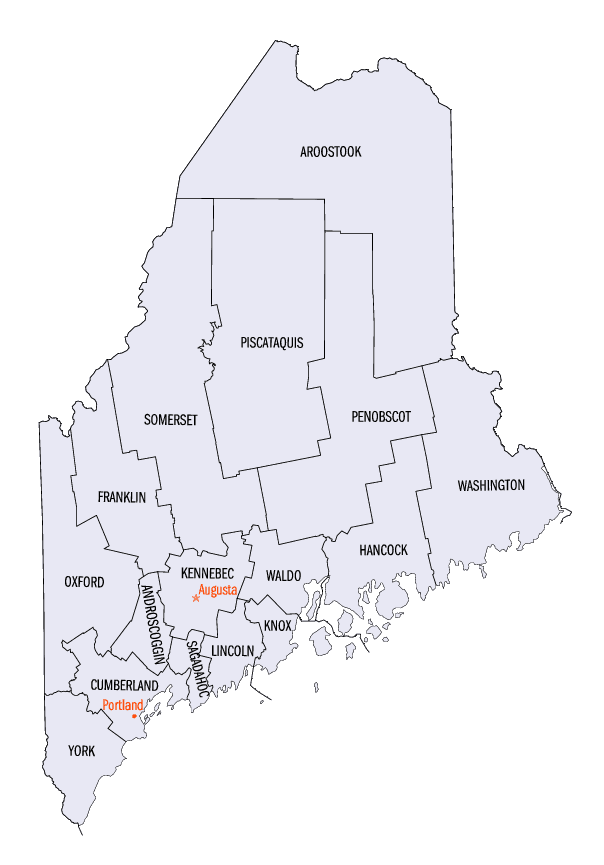
Maine Counties
There are sixteen Counties in Maine. Prior to statehood. The first county to be created was York County, created as York County, Massachusetts by the government of the Massachusetts Bay Colony in 1652. Maine was granted statehood on March 15, 1820 as part of the Missouri Compromise. Nine of the sixteen Counties had their borders defined while Maine was still part of Massachusetts, and hence are older than the state itself. Even after 1820, the exact location of the northern border of Maine was disputed with Britain, until the question was settled and the northern counties took their final, official form by treaty in 1845.Waldo County, Maine
Waldo County Education, Geography, and History
Waldo County is a county located in the state of Maine. Based on the 2010 census, the population was 38,786. Its county seat is Belfast. The county was founded on 7 February 1827 from a portion of Hancock County and named after Brigadier-General Samuel Waldo, proprietor of the Waldo Patent.
Etymology - Origin of Waldo County Name
Waldo is named for Samuel Waldo, a colonial soldier in the siege of Louisberg in 1745.
Demographics:
County QuickFacts: CensusBureau Quick Facts
Waldo County History
History of Waldo County, Maine
From: A Gazetteer of the State of Maine
By Geo. J. Varney
Published by B. B. Russell, 57 Cornhill,
Boston 1886
Waldo County is situated upon the western shores of Penobscot Bay arid River. Knox County forms the southern
border, Kennebec County the western, Somerset the north-western, and Penobscot County the northern. Measuring from
its extreme angles, this county is somewhat near a square in form, although the sides are swelled and broken in,
making a quite irregular outline. Its largest side, and nine of the towns are upon the bay and river; this extent of
shore-line giving excellent maritime facilities. An open winter harbor may, with rare exceptions, he found anywhere
on its coast; while many spacious havens with good depth of water, afford the best of advantages for ship-building,
commerce and the fisheries. The agricultural resources of the county are good, furnishing by far the larger number
of inhabitants with occupation and support.*
Waldo County formed part of York County's territory until 1760, when Lincoln County was established, which included
it until 1789, when Hancock County was erected; this next held it until 1827, when, on February 7th, it was
incorporated as the County of Waldo, and was named for Gen. Samuel Waldo. The erection of Knox County in 1860 took
off from Waldo County the towns of Appleton, Camden, Hope, North Haven and Vinaihaven. In its present form, Waldo
County embraces 25 towns and one city, -the latter being Belfast, the county capital. The population in 1870 was
34,640. In 1880 it was 32,468. The valuation in 1870 was $10,090,581. In 1880 it was $9,577,834.
There are no mountains in the county, strictly speaking, but there are several high hills which have been given the
title. The surface is broken and uneven. in Prospect, Stockton and Frankfort, the view of the Penobseot River and
valley from the high, rounded hills, almost equals the scenery of the Hudson. At Belfast, the harbor has often been
called as beautiful as the Bay of Naples.
A history of Waldo County properly begins with an account of the Muscongus, or Waldo Patent. This grant, issued by
the Plymouth Council in 1630, to John Beauchamp of London, and Thomas Leverett of Boston, Eng., extended on the
seaboard between the Muscongus and Penobscot rivers, and comprised nearly 1,000 square miles, taking in the whole of
the present county of Knox, except the Fox Islands, and of Waldo County, with the exception of territory now covered
by five towns. No price was paid for this tract; it was thought that the settlement of the section would enhance the
value of others. Success in the fisheries at Monhegan, and in other localities along the coast of Maine, hastened an
occupation of the Muscongus grant; and in the spring of 1630, Edward Ashley and William Pierce, agents of the
patentees, came with laborers and mechanics, and established a tradinghouse on the George's River, in what is now
Thomaston.. This settlement was broken up by King Philip's war, which terminated in 1678. After this the whole
territory lay desolate for nearly 40 years. On the death of Beauchamp, Leverett became by law possessed of the whole
grant; and for several years he assumed its management. Through him the patent descended to his son, Governor John
Leverett of Massachusetts, and in 1714, to President John Leverett of Harvard College, the grandson of the latter,
and the great-grandson of the original grantee. In 1719 peace was apparently restored, and Leverett entered upon
measures for re-settling and re-organizing the patent. He parcelled the land into ten shares in common, and conveyed
them to certain persons thenceforth called the "Ten Proprietors." These proprietors admitted 20 other partners
termed the "Twenty Associates," among whom were Cornelius and John Waldo of Boston. The Twenty Associates afterwards
transferred to the Waldos, 100,000 acres. Under their auspices, 1719-20, two plantations, which subsequently became
the thriving towns of Thornaston and Warren, were commenced. This may be regarded as the first permanent settlement
of the patent. In 1726, one David Dunbar, who had obtained an appointment styling him "Surveyor-General of the
King's Woods," became very aggresive. Samuel Waldo was sent to England to procure a revocation of Dunbar's
authority, and in the end succeeded. For this and other valuable services the 30 partners conveyed to him one-half
of the whole patent. In 1744 he distinguished himself at the capture of Louisburg, and gained the title of General
or Brigadier Waldo. After the accession of General Waldo to so large an interest in the patent, added to what he had
inherited of his father's share, about 200,000 acres still belonged to the old proprietors. In 1734 General Waldo
contracted with the Twenty Associates to purchase one-half of their shares, leaving them 100,000 acres. This
arrangement was not completed until 1768. General Waldo offered favorable inducements for European immigration, and
in 1749, German colonists established the town of Waldoborough. Owing to his influence Fort Pownall, Stockton, was
built at a time when no white inhabitant retained a dwelling-place upon the shores of Penobscot River or Belfast
Bay. While upon a tour of observation to this portion of his estate, he died suddenly near Bangor, May 23, 1759, at
the age of 63 years. A county, two thriving towns, and the lofty elevation of Mount Waldo perpetuate his name. The
land descended to the General's four children, Samuel, Francis, Lucy and Hannah. The last named became the wife of
Thomas Flucker, secretary of the Province. Flucker afterward purchased the shares belonging to Samuel. Lucy died
without children, and her interest fell to the brothers and sisters. Flucker and Francis Waldo were Tories. They
removed to England, and their property became forfeited to the State. In 1774, Henry Knox, afterwards a general in
the Revolution, married Miss Lucy Flucker,the second daughter of Thomas and Hannah (Waldo) Flucker, and the
grand-daughter of General Waldo. When the Revolution had ended, General Knox purchased four-fifths of the whole.
patent; the remainder was the property of his wife. The territory was surveyed, the lines adjusted, and in 1792,
General Knox took formal possession of his estate, which then contained only 9 incorporated towns. He did much to
induce immigration. Sometime before his death-which occurred in 1806-he became involved in pecuniary embarrassments.
In 1798 he mortgaged that part of his domain now comprised in Waldo County to General Lincoln and Colonel Jackson,
who had been his sureties. This mortgage was, in 1802, assigned to Messrs. Israel Thorndike, David Sears and William
Prescott of Boston; and they foreclosed it. They established a land agency in Belfast in 1809. Many of the land
titles in Waldo County are derived through these proprietors. It is not known what price was paid for the mortgage
by Thorndike, Sears and Prescott. The valuation of their unsold land in the county was in 1815, $148,000. The lands
owned by the original mortgagees are now alienated excepting Brigadier's or Sear's Island in Searsport,-which is the
property of David and Henry F. Sears of Boston, great-grandsons of the first mortgagee. It was not until the year
1759 that a permanent settlement was planted in Waldo County. The British crown had secured and fortified St. John's
River, and the enemy bad no other outlet to the sea than through the Penobscot River. Governor Pownall of
Massachusetts having called the attention of the legislature to the importance of establishing a fortification at
Penobseot, an expedition, headed by the Governor, proceeded to the region, and began the construction of a fort at
Wasaumkeng Point, now Fort Point, within the present limits of Stockton. It was while accompanying a detachment
which had ascended the river a few miles above where Brewer now stands, and had taken formal possession of the
county for the Province of Massachusetts Bay, that General Samuel Waldo dropped down in a fit of apoplexy, and soon
after expired. The deceased general was buried at the "Point," with military honors and religious services, on the
evening of May 25, 1759. A sermon, the first in Waldo County, was preached by Rev. Mr. Philips. The fort, completed
July 28, 1759, was called Fort Pownall. Until the Revolutionary war a garrison was constantly maintained. General
Jedediah Preble, with a force of 84 men, was first placed in command. Both in civil and military life he so
distinguished himself as to inscribe his name upon the page of history. He was the father of Commodore Preble, a
still more distinguished man. He died at Portland in 1807, at the age of 77. In 1763, General Preble resigned
command of the fort, and was succeeded by Col. Thomas Goldthwait. a native of Chelsea, Massachusetts. He was
paymaster in the expedition against Crown Point in 1755. Whtle resident at Fort Pownall he was commissioned as the
first justice of the peace in this section. He solemnized the first marriages on the river. In 1770 he was
superseded by John Preble, son of the first commander of the fort. But Governor Hutchinson, a zealous royalist,
coming into power the following year, he re-instated Goldthwait into his former office. Being a Tory, Goldthwait
permitted Captain Mowatt, of the British sloop "Canseau" to dismantle the fort and take away its defences in 1775.
This brought down upon him the wrath of the settlers. The next year all his commissions were revoked, and Goldthwait
joined the British forces. He was drowned during the Revolutionary war by the shipwreck of the vessel in which he
had taken passage for Nova Scotia.. In July, 1775, the block-house and all the wooden works were burned to the
ground for fear that they would be occupied by the enemy to the prejudice of the neighboring inhabitants. The
trading-house was kept up until 1777.
The remains of the breastwork of Fort Pownall are still to be seen about 25 rods from the water's edge, in front of
the present great summer hotel called the Wasaumkeag House. Fort Point is the outer promontory of what is now the
town of Stockton, but was the town of Prospect formerly. It rises quite abruptly on the south and east, some 60 or
70 feet from the sea, but on the westerly side a passage opens of easy ascent from the water's edge to the heights
above. Looking down the eastern channel of Penobscot Bay, a long and fine sea-view is had; while all the towns and
villages from Bucksport round nearly to Owl's Head, are distinctly seen. On the old paradeground a growth of
trees-some 18 inches in diameter-now stands.
One of the first centennial celebrations ever held in this country was held at Port Point on the 28th of July, 1859.
The number of persons present was estimated to be at least 8,000.
When it was found that the garrison at Fort Pown all afforded protection and security, the tide of emigration began
to set in the direction of Waldo County. Between 1760 and 1772, all the towns washed by Penobscot waters between
Camden and Bangor on the one side, and Castine and Brewer on the other, were penetrated by hardy yeomanry, designing
here to make a home for themselves and their descendants. All the towns within the shore limits of the county,
except Searsport, Stockton and Winterport, received acts of incoiporation between 1773 and 1812. Little did the men
who erected Fort Pownall, or the men, who, under its protection, first settled the shores of the Penobseot,
apprehend what marvellous changes the succeeding century would witness.
* The remainder of this article is mainly extracted from Crocker and Howard's History of New England, being so
complete and yet so succinct that any improvement upon it would be difficult. The author is Albert C. Wiggin.
Waldo County
Geography: Land and Water
As reported by the Census Bureau, the county has a total area of 853 square miles (2,209 km2), of which, 730
square miles (1,890 km2) of it is land and 123 square miles (319 km2) of it (14.43%) is water.
Neighboring Counties
Bordering counties are as follows:
- Penobscot County, Maine - northeast
- Hancock County, Maine - east
- Knox County, Maine - south
- Lincoln County, Maine - southwest
- Kennebec County, Maine - west
- Somerset County, Maine - northwest
Education


Click Image to Enlarge
