

Click Image to Enlarge
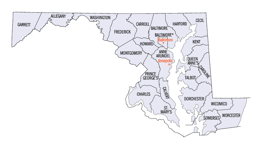
Maryland Counties
There are twenty-four counties and county-equivalents in Maryland. Though an independent city rather than a county, the City of Baltimore is considered the equal of a county. The last new county formation in Maryland occurred when Garrett County was formed in 1872 from portions of Allegany County.Montgomery County, Maryland
Montgomery County Education, Geography, and History
Montgomery County is a county in the state of Maryland. Based on the 2010 census, the population was 971,777, and a 2014 estimate put the
population at 1,030,447. It is the most populous county in Maryland. The county seat and largest municipality is Rockville, although the
census-designated place of Germantown is the most populous place.
Montgomery County is included in the Washington-Arlington-Alexandria, DC-VA-MD-WV Metropolitan Statistical Area.
Etymology - Origin of Montgomery County Name
Richard Montgomery, an American Revolutionary War general
Demographics:
County QuickFacts: CensusBureau Quick Facts
Montgomery County History
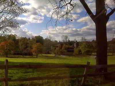
Before European immigration, the land now known as Montgomery County was covered in a vast swath of forest
crossed by the creeks and small streams that feed the Potomac and Patuxent rivers. A few small villages of the Piscataway, members of the
Algonquian people, were scattered across the southern portions of the county. North of the Great Falls of the Potomac, there were few
permanent settlements, and the Piscataway shared hunting camps and foot paths with members of rival peoples like the Susquehannocks and the
Senecas.
Captain John Smith of the English settlement at Jamestown was probably the first European to explore the area, during his travels along the
Potomac River and throughout the Chesapeake region.
The Madison House in Brookeville was built around 1800 and originally owned by Caleb Bentley. The house provided refuge for President James
Madison, on August 26, 1814, after the British burned Washington, DC, during the War of 1812.
These lands were claimed by Europeans for the first time when George Calvert, 1st Baron Baltimore was granted the charter for the colony of
Maryland by Charles I of England. However, it was not until 1688 that the first tract of land in what is now Montgomery County was granted by
the Calvert family to an individual colonist, a wealthy and prominent early Marylander named Henry Darnall. He and other early claimants had
no intention of settling their families. They were little more than speculators, securing grants from the colonial leadership and then selling
their lands in pieces to settlers. Thus, it was not until approximately 1715 that the first British settlers began building farms and
plantations in the area.
These earliest settlers were English or Scottish immigrants from other portions of Maryland, German settlers moving down from Pennsylvania, or
Quakers who came to settle on land granted to a convert named James Brooke in what is now Brookeville. Most of these early settlers were small
farmers, growing wheat and a variety of other subsistence crops in addition to the region's main cash crop, tobacco. Many of the farmers owned
slaves. They transported the tobacco they grew to market through the Potomac River port of Georgetown. Sparsely settled, the area's farms and
taverns were nonetheless of strategic importance as access to the interior. General Edward Braddock's army traveled through the county on the
way to its disastrous defeat at Fort Duquesne during the French and Indian War.
Like other regions of the American colonies, the region that is now Montgomery County saw protests against British taxation in the years
before the American Revolution. In 1774, local residents met at Hungerford's Tavern and agreed to break off commerce with Great Britain.
Following the signing of the Declaration of Independence, representatives of the area helped to draft the new state constitution and began to
build a Maryland free of proprietary control. On September 6, 1776, the Maryland Constitutional Convention formed Montgomery County from lands
that had at one point or another been part of Charles, Prince George's and Frederick Counties, naming it after General Richard Montgomery. The
leaders of the new county chose as their county seat an area adjacent to Hungerford's Tavern near the center of the county, which later became
Rockville. The newly formed Montgomery County supplied arms, food and forage for the Continental Army during the Revolution, in addition to
soldiers.
In 1791, portions of Montgomery County, including Georgetown, were ceded to form the new District of Columbia, along with portions of Prince
George's County, Maryland, as well as parts of Virginia that were later returned to Virginia.
Geography: Land and Water
As reported by the Census Bureau, the county has a total area of 507 square miles (1,310 km2), of which 491 square miles (1,270 km2) is
land and 16 square miles (41 km2) (3.1%) is water. Montgomery County lies entirely inside the Piedmont plateau. The topography is generally
rolling. Elevations range from a low of near sea level along the Potomac River to about 875 feet in the northernmost portion of the county
north of Damascus. Relief between valley bottoms and hilltops is several hundred feet.
When Montgomery County was created in 1776, its boundaries were defined as "beginning at the east side of the mouth of Rock creek on Potowmac
river, and running with the said river to the mouth of Monocacy, then with a straight line to Par's spring, from thence with the lines of the
county to the beginning".
The county's boundary forms a sliver of land at the far northern tip of the county that is several miles long and averages less than 200 yards
wide. In fact, a single house on Lakeview Drive and its yard is sectioned by this sliver into 3 portions, each separately contained within
Montgomery, Frederick and Howard Counties. These jurisdictions and Carroll County meet at a single point at Parr's Spring on Parr's Ridge.
Neighboring Counties
Bordering counties are as follows:
- Northeast: Carroll County; Howard County
- Southeast: Prince George's County; Washington city,D.C.;Arlington County, Va.
- South: Fairfax County, Va.
- West: Loudoun County, Va.
- Northwest: Frederick County
Education
Educative system is conformed by Montgomery County Public Schools, Montgomery College and other institutions in the area.
Montgomery County Public Schools
Elementary and secondary public schools are operated by the Montgomery County Public Schools and has a budget of 3.41 US$Billions for 2015.
Colleges
The county is also served by Montgomery College, a public, open access community college that has a budget of 950 US$ Millions for 2015. The county has no public university of its own, but the state university system does operate a facility called Universities at Shady Grove in Rockville that provides access to baccalaureate and Master's level programs from several of the state's public universities.


Click Image to Enlarge
