


Maryland Geography: The Land
Geography and Landforms of Maryland
 Find an overview of Maryland geography,
topography, geographic land regions, land areas, and major rivers.
Find an overview of Maryland geography,
topography, geographic land regions, land areas, and major rivers.
Access Maryland almanac, furnishing more details on the state geography, geographical and land regions, climate and weather, elevation, land areas, bordering states, and other statistical data.
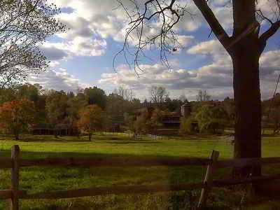
The Chesapeake Bay divides Maryland into two sections -the Eastern Shore and the Western Shore. The state is made up of 5 distinct land regions listed below.
Maryland Highest, Lowest, & Mean Elevations |
||
|---|---|---|
| Mean Elevation | 350 ft. | |
| Highest Point | Backbone Mountain 3360 feet |
|
| Lowest Point | Atlantic Ocean Sea level |
|
Maryland Land Area (Square Miles) |
||
| Geographic Center | In Prince Georges County, 41/2 mi. NW of Davidsonville Longitude: 77° 22.3'W Latitude: 39° 29.5'N |
|
| Total Area | 12,406.68 sq. mi. 42nd |
|
| Land Area | 9,773.82 sq. mi. | |
| Water Area | 2,632.86 sq. mi. 21.21% |
|
| Forested Land Area | 42.9% | |
| Dimensions (Length - Width) |
250 miles - 90 miles | |
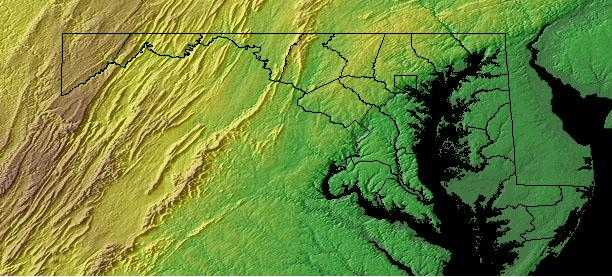
Maryland: Physiographic Areas.
The state can be divided into the following regions:
- Appalachian Plateau
- Blue Ridge Region
- Piedmont
Mid-Atlantic Piedmont
The eastern border of the Piedmont is the fall line, where resistant volcanic rock gives way to the sands and clays of the Coastal Plain. To the west, the Piedmont ends with the edge of the higher and more rugged Blue Ridge and Ridge and Valley regions of the Appalachian Mountains The Mid-Atlantic Piedmont is arbitrarily separated from the Southern Piedmont at the North Carolina-Virginia line, and extends north through Virginia, Maryland, and Pennsylvania before terminating in northern New Jersey. The rolling topography of the Piedmont formerly supported an extensive hardwood forest, with an oak-hickory type predominant in southern portions and Appalachian oak to the north. Large areas in the Virginia portion were dominated by Loblolly-shortleaf pine or pine-oak forests. Today, roughly 45% of the physiographic area is forested, and about an equal portion is in agricultural production. The remainder is experiencing rapid urbanization, especially in the vicinity of Washington D.C. and Philadelphia.
Mid-Atlantic Coastal Plain
The Mid-Atlantic Coastal Plain extends from the Atlantic Ocean, south of Long Island, to the Fall Line, where the hilly Piedmont begins. It is arbitrarily separated from the South Atlantic Coastal Plain at the Virginia-North Carolina border (with the exception of the Great Dismal Swamp in the southeast corner of Virginia, which is grouped in the southern area). The area was formed by shifting sea levels and alluvial deposition from rivers draining mountains to the west. Water continues to be a dominant feature of the landscape, creating forested wetlands and salt marsh and shaping barrier island and bay complexes. Upland forests on the remaining land graded in composition from pine dominated areas on the outer Coastal Plain (nearer the coast) to hardwood forests on the inner Coastal Plain. This was the site of the first successful English settlement in North America, and the natural landscape has been altered by European culture for nearly four centuries. The current human population approaches 11 million and is expected to continue to expand into the future, placing ever-increasing demands on the region's natural resources.
Mid-Atlantic Ridge and Valley
The Mid-Atlantic Ridge and Valley extends from western Maryland, through the mountains of Virginia and eastern West Virginia. Most of this physiographic
area consists of long mountainous ridges and intervening valleys, but it also includes the higher Allegheny Mountains of West Virginia. Predominant
vegetation consists of oak and oak-hickory forests on the ridges and northern hardwood forest in the Allegheny Mountains. Important relict patches
of spruce-fir exist in the Allegheny Mountains and on higher mountains along the ridge and valley of Virginia. Much of the lower valleys are in agricultural
production or urban development. Human populations are relatively sparse throughout the physiographic area and are largely confined to the larger valleys.
Suburban and second-home development is rapidly encroaching from large urban centers to the East. Timber extraction has been a major activity throughout
the history of this region, and it continues to be important on both public and privately owned forest lands. Extraction of minerals, oil and gas,
and coal are also important land uses throughout this region. At present, one of the most important disturbance factors affecting forested habitats
in this region is the prevalence and spread of native and exotic insect pests and disease. Beginning with American chestnut blight, a series of such
elements threaten the integrity and health of Appalachian forest ecosystems.
This region includes a wide strip of the Appalachian Mountains and the Blue Ridge Mountains. It is heavily forested and hide caverns and underground streams.
Along the western edge of the mountains is the Allegheny Front, the place where the more sharp, rugged mountains of the east meet the more rolling terrain of the Appalachian Plateau. Many of the peaks in this area of West Virginia rise to over 4,000 feet above sea level. Spruce Knob, the highest point in West Virginia, rises 4,861 feet above sea level in the Appalachian Ridge and Valley Region.
Maryland Landscape and Landforms:
Atlantic Coastal Plain
The Atlantic Coastal Plain covers all of the Western Shore and part of the Eastern Shore. It is a flat area that rises gradually to a height of 400 feet to the west. Along the Chesapeake, the Plain has many indented shorelines, small bays, and estuaries.
Piedmont
A region of rolling hills and fertile valleys, known as the Piedmont, lies to the north and west. It is a 50-mile wide area that rises to meet the narrow, mountainous Blue Ridge region.
Blue Ridge Region
This region extends from southern Pennsylvania south to northern Georgia. In Maryland, the Blue Ridge is represented by a narrow, mountainous section of land between the Piedmont and the Appalachian Ridge and Valley. This region, mostly over 1,000 feet, lies in northern Maryland near the Pennsylvania border. South Mountain and Catoctin Mountain are in the Blue Ridge Region of Maryland.
Appalachian Ridge and Valley
In Maryland, this region separates Pennsylvania from West Virginia. At its narrowest point, this strip of land measures less than 2 miles from north to south.
Appalachian Plateau
To the west, the Appalachian Plateau contains Maryland's highest point, Backbone Mountain, which is 3,360 feet above sea level. The Allegheny Mountains make up a large part of this heavily forested area.

