

Click Image to Enlarge
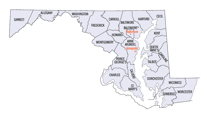
Maryland Counties
There are twenty-four counties and county-equivalents in Maryland. Though an independent city rather than a county, the City of Baltimore is considered the equal of a county. The last new county formation in Maryland occurred when Garrett County was formed in 1872 from portions of Allegany County.Somerset County, Maryland
Somerset County Education, Geography, and History
Somerset County is the southernmost county in the American State of Maryland. Based on the 2010 census, the population was 26,470. making it
the second-least populous county in Maryland. The county seat is Princess Anne. The county was named for Mary, Lady Somerset, the wife of Sir
John Somerset and daughter of Thomas Arundell, 1st Baron Arundell of Wardour (ca 1560-1639).
Somerset County is included in the Salisbury, MD-DE Metropolitan Statistical Area. It is located on the state's Eastern Shore
Etymology - Origin of Somerset County Name
The county was named for Mary, Lady Somerset, the wife of Sir John Somerset and daughter of Thomas Arundell, 1st Baron Arundell of Wardour (ca 1560-1639). She was also the sister of Anne Calvert, Baroness Baltimore (1615-1649), who later lent her name to Anne Arundel County, which was erected in 1650 as the Province of Maryland's third county.
Demographics:
County QuickFacts: CensusBureau Quick Facts
Somerset County History
Somerset County was settled and established in part due to a response to the Province/Dominion of Virginia passing
a law in 1659/1660 requiring Quakers in the colony to convert to Anglicanism or leave the colony. A group of Virginia Quakers living in
Accomac County, Virginia on the southern tip of the future Delmarva Peninsula, petitioned Charles Calvert, third Lord Baltimore in 1661 to
migrate further north on the Eastern Shore of the Chesapeake Bay to the territory under his governance, and the governor saw the opportunity
to fortify the borders of his territory on the Delmarva Peninsula against the pressing encroachment of the Virginians.
The Royal Charter that Lord Baltimore had received from King Charles I in 1632 had granted Maryland the land north of the entire length of the
Potomac River up to the 40th parallel. Later surveys authorized by Baltimore on the Eastern Shore of the Chesapeake Bay indicated that the
southern boundary would continue across the peninsula at the mouth of the Pocomoke River marked on the north shore by a rock outcropping
labelled as "Watkins' Point". The Virginian Quakers settled just a bit north of that point, on the southern bank of the Annemessex River in
November, 1662, and a separate group of Anglican Virginian settlers were granted permission to make a second settlement further north along
the Manokin River.
In conjunction with the two new settlements, Baltimore set up a three-man commission for the Eastern Shore territory, made up of two
Marylanders and one Virginian. Its purpose was ostensibly to oversee the territory and the establishment of new settlements and maintain a
detailed recording of all land and civic transactions in the area; but in fact Lord Baltimore intended to use the commission to reinforce
Maryland's claim to the area and to monitor any encroachments by the Virginians
The northernmost boundary of the county was also in dispute. Baltimore believed his Eastern Shore territory extended all the way up to the top of the peninsula, where the Delaware River meets the Bay. In the 1680s, William Penn claimed this territory as his own, however, on the basis of a conflicting deed. Penn, Baltimore, and their heirs began a protracted legal battle to determine the exact boundaries. Their compromise was to split the Delmarva Peninsula; however they disagreed as to whether the boundary line should be drawn at the location of Cape Henlopen or at Fenwick Island. Unlike the dispute of Somerset's southern border, there were few settlers in the frontier on either side to take issue. That boundary would finally be settled in 1763 when surveyors Charles Mason and Jeremiah Dixon incorporated the Transpeninsular Line as the definitive boundary between Delaware and Maryland.
Geography: Land and Water
As reported by the Census Bureau, the county has a total area of 610 square miles (1,600 km2), of which 320 square miles (830 km2) is land and 291 square miles (750 km2) (48%) is water.
Neighboring Counties
Bordering counties are as follows:
- North: Wicomico County
- East: Worcester County
- South: Accomack County, Va.
- West: Chesapeake Bay
Education


Click Image to Enlarge
