

Click Image to Enlarge
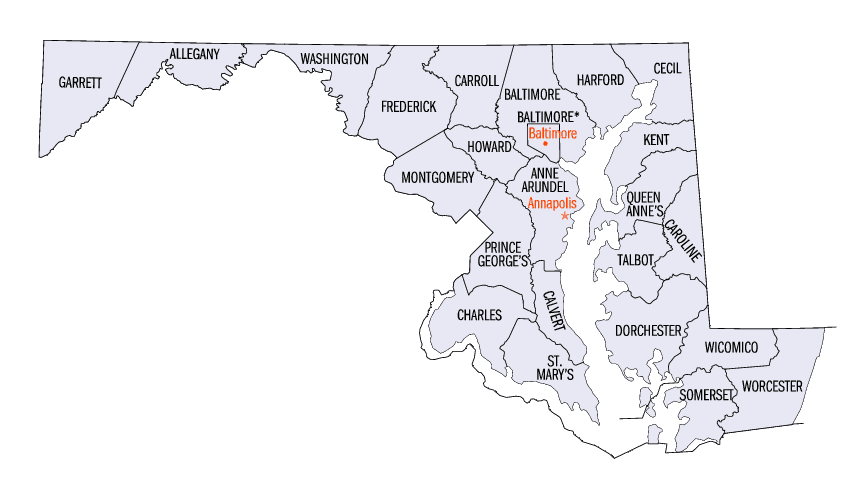
Maryland Counties
There are twenty-four counties and county-equivalents in Maryland. Though an independent city rather than a county, the City of Baltimore is considered the equal of a county. The last new county formation in Maryland occurred when Garrett County was formed in 1872 from portions of Allegany County.Talbot County, Maryland
Talbot County Education, Geography, and History
Talbot County is a county located in the heart of the Eastern Shore of Maryland in the state of Maryland. Based on the 2010 census, the
population was 37,782. Its county seat is Easton. The county was named for Lady Grace Talbot, the wife of Sir Robert Talbot, an Anglo-Irish
statesman, and the sister of Lord Baltimore.
Talbot County comprises the Easton, MD Micropolitan Statistical Area, which is also included in the Washington-Baltimore-Arlington,
DC-MD-VA-WV-PA Combined Statistical Area.
Etymology - Origin of Talbot County Name
The county was named for Lady Grace Talbot, the wife of Sir Robert Talbot, an Anglo-Irish statesman, and the sister of Lord Baltimore.
Demographics:
County QuickFacts: CensusBureau Quick Facts
Talbot County History
The founding date of Talbot County is not known. It existed by February 12, 1661, when a writ was issued to its
sheriff. It was initially divided into nine Hundreds and three parishes: St. Paul's, St. Peter's and St. Michael's.
In 1667, the first meeting of Commissions was held in the home known as Widow Winkles on the Skipton Creek near the town of York. The town of
York was vacated once the courthouse was to be built on Armstrongs Old Field in 1709 near Pitts' Bridge. The new courthouse designated because
York was too far north in the county once Queen Anne's County received their charter and was lopped off of Talbot County. Pitts' Bridge was
just north of the Quaker Meeting House, but most importantly, it faced the Indian trail (Washington Street - Easton)
Geography: Land and Water
As reported by the Census Bureau, the county has a total area of 477 square miles (1,240 km2), of which 269 square miles (700 km2) is land and 208 square miles (540 km2) (44%) is water. It is the third-smallest county in Maryland by land area.
Neighboring Counties
Bordering counties are as follows:
- North: Queen Anne's County
- East: Caroline County
- South: Dorchester County
- West: Chesapeake Bay
Education
Schools are part of the Talbot County Public Schools district.


Click Image to Enlarge
