


Click Image to Enlarge
Michigan Counties
The boundaries of the eighty-three counties in Michigan have not changed substantially since 1897. Wayne County was the sixth county in the Northwest Territory, formed 15 August 1796 and organized in 1815. Wayne County was created 21 November 1815 as an original county of Michigan.Cass County, Michigan
Cass County Education, Geography, and History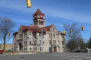
Cass County is a county in the state of Michigan. Based on the 2010 census, the population was 52,293. Its county seat is Cassopolis.
Cass County is included in the South Bend-Mishawaka, IN-MI, Metropolitan Statistical Area which has a total population of 316,663 and is
sometimes considered part of Greater Michiana. Cass County has numerous lakes and is popular for fishing and boating.
Etymology - Origin of Cass County Name
The county is named for the Michigan Territorial Governor, Lewis Cass at the time the county was created in 1829. Cass later served as the United States Secretary of War under President Andrew Jackson, thus making a case for including Cass County as one of Michigan's "cabinet counties".
Demographics:
County QuickFacts: CensusBureau Quick Facts
Cass County History
Cass County, named for territorial governor and Secretary of War Lewis Cass, and is a Cabinet county.
Sett Off: 1829
Organized: 1829
The county is named for Lewis Cass, the Michigan Territorial Governor at the time the county was created in 1829. Cass later served as the
United States Secretary of War under President Andrew Jackson, thus making a case for including Cass County as one of Michigan's "cabinet
counties".
Cass County was not as heavily forested and had more fertile prairie land than other nearby areas of Michigan, and thus during early
settlement it grew more rapidly in population. As early as 1830, a carding mill was started in the county on Dowagiac Creek, a branch of the
St. Joseph River. Although the Sauk Trail (Chicago Road) passed through the southern part of the county, early settlement did not come
primarily from eastern Michigan. Instead, settlers from Ohio and Indiana who had heard of the prairie lands came to occupy them, reaching the
Michigan Territory over a branch of the Chicago Road leading from Fort Wayne, Indiana. The population of Cass County was over 3,000 by 1834.
Among the most prominent early settlers of Cass County were Baldwin Jenkins and Uzziel Putnam, who both came from Ohio by way of the Carey
Mission in Berrien County. Jenkins had been born at Fort Jenkins in Green County, Pennsylvania, and had migrated to Tennessee, but then left
that state to avoid the presence of slavery. Putnam, who had lived in Massachusetts and New York, came to Cass from Erie County, Ohio, by way
of Fort Wayne. These settlers, and their families, established the nucleus of the village of Pokagon on Pokagon Prairie in 1825. The next
year, a settlement was made on Beardsley's Prairie, where the village of Edwardsburg was laid out in 1831.
The village of Cassopolis was platted in 1831 and intended as the county seat, although no settlers yet lived there, because it was the
geographical center of the county
Geography: Land and Water
As reported by the Census Bureau, the county has a total area of 508 square miles (1,320 km2), of which 490 square miles (1,300 km2) is land and 18 square miles (47 km2) (3.6%) is water. It is the smallest county in Michigan by total area.
Neighboring Counties
Bordering counties are as follows:
- Van Buren County (north)
- St. Joseph County (east)
- Berrien County (west)
- Elkhart County, Indiana (southeast)
- St. Joseph County, Indiana (southwest)
Education
Higher Education
Cass County is home to Southwestern Michigan College. The college is a public two-year institution of higher education, the college is part of the Michigan community college system. The college is the largest employer in Cass County.


Click Image to Enlarge
