


Click Image to Enlarge
Michigan Counties
The boundaries of the eighty-three counties in Michigan have not changed substantially since 1897. Wayne County was the sixth county in the Northwest Territory, formed 15 August 1796 and organized in 1815. Wayne County was created 21 November 1815 as an original county of Michigan.Dickinson County, Michigan
Dickinson County Education, Geography, and History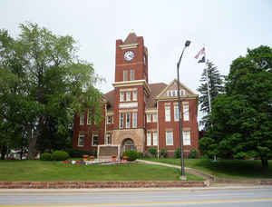
Dickinson County is a county in the Upper peninsula of the state of Michigan. Based on the 2010 census, the population was 26,168. The
county seat is Iron Mountain. Dickinson is Michigan's newest county, formed in 1891 from parts of Marquette, Menominee, and Iron counties. It
was named for Don M. Dickinson (D), US Postmaster General under President Grover Cleveland.
Dickinson County is part of the Iron Mountain, MI-WI Micropolitan Statistical Area.
Etymology - Origin of Dickinson County Name
Dickinson County is named for Don M. Dickinson, US Postmaster General under Grover Cleveland.
Demographics:
County QuickFacts: CensusBureau Quick Facts
Dickinson County History
Dickinson is Michigan's newest county, formed in 1891 from parts of Marquette, Menominee, and Iron counties. It was named for Don M. Dickinson (D), US Postmaster General under President Grover Cleveland.
Set Off: 1891
Organized: 1891
Geography: Land and Water
As reported by the Census Bureau, the county has a total area of 777 square miles (2,010 km2), of which 761 square miles (1,970 km2) is land and 16 square miles (41 km2) (2.0%) is water
Neighboring Counties
Bordering counties are as follows:
- Marquette County (north)
- Menominee County (southeast)
- Marinette County, Wisconsin (south)
- Florence County, Wisconsin (southwest)
- Iron County (west)
Education


Click Image to Enlarge
