


Click Image to Enlarge
Michigan Counties
The boundaries of the eighty-three counties in Michigan have not changed substantially since 1897. Wayne County was the sixth county in the Northwest Territory, formed 15 August 1796 and organized in 1815. Wayne County was created 21 November 1815 as an original county of Michigan.Hillsdale County, Michigan
Hillsdale County Education, Geography, and History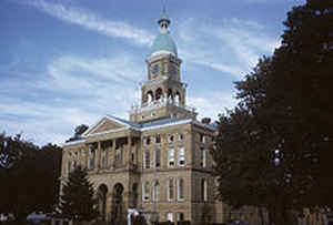
Hillsdale County is a county located in the state of Michigan. Based on the 2010 census, the population was 46,688. The county seat is
Hillsdale.
Hillsdale County comprises the Hillsdale, MI Micropolitan Statistical Area.
Etymology - Origin of Hillsdale County Name
The rolling terrain of the area served as the basis for the name of the county
Demographics:
County QuickFacts: CensusBureau Quick Facts
Hillsdale County History
The rolling terrain of the area served as the basis for the name of the county
Set Off: 1829
Organized: 1835
The county is named for its rolling terrain.[ It was set off in 1829, and organized six years later. See List of Michigan county name etymologies. Hillsdale County was a New England settlement. The original founders of Hillsdale consisted entirely of settlers from New England. These people were "Yankee's", that is to say they were descended from the English Puritans who settled New England in the 1600s. They were part of a wave of New England farmers who headed west into what was then the wilds of the Northwest Territory during the early 1800s. Most of them arrived as a result of the completion of the Erie Canal as well as the close of the Black Hawk War. When they arrived in what is now Hillsdale County there was nothing but a virgin forest and wild prairie, the New Englanders laid out farms, constructed roads, erected government buildings and established post routes. They brought with them many of their Yankee New England values, such as a passion for education, establishing many schools as well as staunch support for abolitionism. They were mostly members of the Congregationalist Church though some were Episcopalian, however as a result of the Second Great Awakening many became Baptists and many also converted to Methodism before arriving in Michigan. The people of Hillsdale County, like many others in Michigan, maintained a cultural affinity with early New England
Geography: Land and Water
As reported by the Census Bureau, the county has a total area of 607 square miles (1,570 km2), of which 598 square miles (1,550 km2) is land and 8.9 square miles (23 km2) (1.5%) is water. Hillsdale is the only county in Michigan to border two other states. Within the county also exists the head waters of two St. Joseph Rivers, the St. Joseph River (Lake Michigan) and the St. Joseph River (Maumee River). The county is divided into 18 townships. From Northwest to Southeast, they are Litchfield, Scipio, Moscow, Somerset, Allen, Fayette, Hillsdale, Adams, Wheatland, Reading, Cambria, Jefferson, Pittsford, Camden, Woodbridge, Ransom, Amboy, and Wright.
Neighboring Counties
Bordering counties are as follows:
- Jackson County (northeast)
- Calhoun County (northwest)
- Lenawee County (east)
- Branch County (west)
- Fulton County, Ohio (southeast)
- Williams County, Ohio (south)
- Steuben County, Indiana (southwest)
Education


Click Image to Enlarge
