


Michigan Counties

Click Image to Enlarge
Michigan Counties
The boundaries of the eighty-three counties in Michigan have not changed substantially since 1897. Wayne County was the sixth county in the Northwest Territory, formed 15 August 1796 and organized in 1815. Wayne County was created 21 November 1815 as an original county of Michigan.Mason County, Michigan
Mason County Education, Geography, and History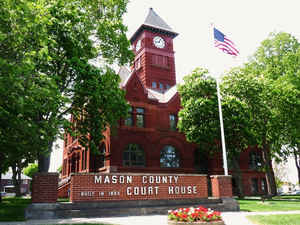
Mason County is a county located in the state of Michigan. Based on the 2010 census, the population was 28,705. The county seat is
Ludington.
Mason County comprises the Ludington, MI Micropolitan Statistical Area.
Etymology - Origin of Mason County Name
Mason County is named for Michigan Governor Stevens T. Mason.
Demographics:
County QuickFacts: CensusBureau Quick Facts
Mason County History
Mason County is named for Michigan Governor Stevens T. Mason.
Set Off: 1840 as Notipekago. Name changed to Mason in 1843
Organized: 1855
Geography: Land and Water
As reported by the Census Bureau, the county has a total area of 1,242 square miles (3,220 km2), of which 495 square miles (1,280 km2) is land and 747 square miles (1,930 km2) (60%) is water
Neighboring Counties
Bordering counties are as follows:
- Manistee (north)
- Lake (east)
- Newaygo (southeast)
- Oceana (south)
Education
Compare More Colleges and Universities

County Resources

Click Image to Enlarge

Search
© Copyright 2004-2024, eRD (eReferenceDesk.com) owned and operated by Joseph L Ferguson. All rights reserved.