


Click Image to Enlarge
Minnesota Counties
There are eighty-seven Counties in Minnesota. On October 27, 1849 nine large Minnesota Counties were created. Among them were Benton, Dahkotah, Itasca, Ramsey, Mahkahta, Pembina, Wabashaw, Washington, and Wahnata. Of those Benton, Dakota, Itasca, Ramsey, Wabasha, and Washington still exist as their original name. With the creation of Kittson County on March 9, 1878, Pembina County no longer existed. When Minnesota was organized as a state, 57 of the present 87 Counties were established. The last county to be created was Lake of the Woods County in 1923Aitkin County, Minnesota
Aitkin County Education, Geography, and History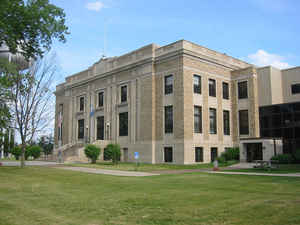
Aitkin County is a county located in the state of Minnesota. Based on the 2010 census, the population was 16,202. Its county seat is Aitkin. A portion of the Mille Lacs Indian Reservation is in the county. The county was created in 1857 and organized in 1871. Named for William Alexander Aitken (whose name is properly spelled with an "e"), a fur trader with the Ojibways.
Etymology - Origin of Aitkin County Name
Aitkin County was established in 1857 as Aiken County and had a spelling change of its name to the current spelling in 1872. Aitkin County was named after William Alexander Aitken, a fur trader for the American Fur Company, under John Jacob Astor.
Demographics:
County QuickFacts: CensusBureau Quick Facts
Aitkin County History
Thousands of years ago, the melting of a glacial ice sheet resulted in a lake about 20 miles long and 5 miles wide.
This lake was later called Glacial Lake Aitkin. The gradual melting of this glacier was the beginning of the Mississippi
River drainage system. There are at least seven other rivers or streams draining into the Mississippi between Aitkin and
Grand Rapids.
Lake Aitkin existed geologically for a very short period of time and created a series of smaller lakes now located in
the area of Aitkin County.
Sioux Indians were among the original occupants of the area. During the 1600's, the Ojibwa / Chippewa forced the Sioux
to move westward into what is now southwestern Minnesota and the Dakotas. There were many bloody battles for the Aitkin
County area because the area was recognized as a rich hunting paradise. This area will forever remain rich in Native
American history.
The County of Aitkin was named after William Aitkin whose occupation was an English fur trader. Aitkin was an adventurer
well able to take care of himself in the wilderness and at ease among his own race as well as with the natives he traded
with. Aitkin was a clerk in the American Fur Company that operated on the west side of Sandy Lake near the present Libby
Dam site. William Aitkin married Stripped Cloud, an Ojibwa lady around 1818 and together they raised seven children.
Aitkin remained active in the fur trade until his death in 1851.
Aitkin County was organized May 23, 1857. It was then that the Minnesota Territorial Legislature designated Aitkin as a
county.
Construction of the Northern Pacific Railroad in 1871 brought dramatic changes to the Aitkin area. The railroad
stimulated the logging industry and commerce with the Village of Aitkin, becoming the first permanent white settlement
in Aitkin County.
The Mississippi River also provided a flourishing means of travel and commerce from the mid 1880's to the early 1920's,
giving the area a rich history of riverboats, railroading, logging, and immigrant life.
For more detailed historical information, visit the Aitkin County Historical Society's page - www.aitkin.com/achs/, www.cpinternet.com/~achs/ or the Aitkin Chamber of Commerce page - www.aitkin.com/fest/history.htm
Aitkin County covers an area of 1,215,669 acres (1,828 sq. miles) with 55 full and fractional congressional townships.
Aitkin County had a population of 15,301 in the 2000 census. The City of Aitkin is the county seat where the county
courthouse is located. The present day courthouse was built in 1929 after the first courthouse burned. The Aitkin County
Veterans Memorial is located on the Courthouse grounds.
Aitkin County has 365 lakes, 10 school districts, 1647 miles of road, 123,000 acres of water (not counting rivers) and
95 miles of the Mississippi River.
The highest point in the County of Aitkin is Quadna Mountain which is 1,589 feet above sea level. The city of Aitkin is
1200 feet above sea level.
The largest industries in Aitkin County are tourism, forest products, and agriculture.
Geography: Land and Water
As reported by the Census Bureau, the county has a total area of 1,995 square miles (5,170 km2), of which 1,822 square miles (4,720 km2)
is land and 174 square miles (450 km2) (8.7%) is water
Neighboring Counties
Bordering counties are as follows:
- Itasca County (north)
- Saint Louis County (northeast)
- Carlton County (east)
- Pine County (southeast)
- Kanabec County (south)
- Mille Lacs County (south)
- Crow Wing County (southwest)
- Cass County (northwest)
Education


Click Image to Enlarge
