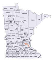
Minnesota Counties
There are eighty-seven Counties in Minnesota. On October 27, 1849 nine large Minnesota Counties were created. Among them were Benton, Dahkotah, Itasca, Ramsey, Mahkahta, Pembina, Wabashaw, Washington, and Wahnata. Of those Benton, Dakota, Itasca, Ramsey, Wabasha, and Washington still exist as their original name. With the creation of Kittson County on March 9, 1878, Pembina County no longer existed. When Minnesota was organized as a state, 57 of the present 87 Counties were established. The last county to be created was Lake of the Woods County in 1923Carver County, Minnesota
Carver County Education, Geography, and History
Carver County is a county located in the state of Minnesota. Based on the 2010 census, the population was 91,042. Its county seat is
Chaska. Carver County is named after the explorer Jonathan Carver, who in 1766-67, traveled from Boston to the Minnesota River, and wintered
among the Sioux near the site of New Ulm.
Carver County is part of the Minneapolis-St. Paul-Bloomington, MN-WI Metropolitan Statistical Area.
Etymology - Origin of Carver County Name
Named for Captain Jonathan Carver, noted explorer and author, traveled through Minnesota in 1766-67.
Demographics:
County QuickFacts: CensusBureau Quick Facts
Carver County History
Carver County, founded in 1855, is home to the Minnesota and Crow Rivers, along with 125 lakes. Located southwest of
the Twin Cities, it is part of the seven-county metro area.
The area named Carver County has been home to American Indians, immigrants, and many others throughout its long history. Many thousands of
years ago, Minnesota was covered by glaciers and the First People, early American Indians, who hunted mammoths and giant bison. As the ice
melted, the people changed how they hunted and lived. They made their own tools from bone or rock. This process is called flint knapping. Most
hunted with spears or bow and arrow. Trade with neighboring groups was important, but trade also stretched across the country. Archaeologists
found a cowry shell, an object found in the Pacific Ocean, in a Carver County archaeology site in Camden Township.
The British controlled the fur trade in the late 1700s and then the Americans took over in the early 1800s. The Indians tried to create the
same family bonds with them as they had with the French. They referred to "Grandmother England" and "The Great Father in Washington." However,
the British and the Americans did not understand the importance of kinship ties to the Dakota. Indian-White relations declined. The fur trade
period ended in 1851 with the signing of two important treaties.
The Treaty of Traverse de Sioux was signed July 23, 1851, and the Treaty of Mendota signed in August 1851, with the Sisseton and Wahpeton
bands (Traverse de Sioux) and Wahpekute and Mdewakanton bands (Mendota) of Dakota Indians. These treaties opened what is now Carver County to
settlement by white settlers. Many whites had settled the land prior to the treaties, illegally. These illegal settlers are sometimes known as
"Sooners", and many of them were forced to give up their land. They either moved back east again or made their homes on different land,
legally.
Carver County became an official county on March 3, 1855, named for early explorer, Jonathan Carver, as is the city of Carver. It is divided
into ten townships: Hollywood, Watertown, Camden, Waconia, Laketown, Young America, Benton, Dahlgren, Hancock, and San Francisco. San
Francisco was the first county seat until government official moved it to Chaska in 1856 where it remains despite battles to move the county
seat to other locations.
Geography: Land and Water
As reported by the Census Bureau, the county has a total area of 376 square miles (970 km2), of which 354 square miles (920 km2) is land
and 22 square miles (57 km2) (5.8%) is water. It is the second-smallest county in Minnesota by land area and third-smallest by total area.
Carver is one of seven southern Minnesota counties with no forest soils; only prairie ecosystems of savannas and prairies can be found in
Carver County. It is also one of 17 Minnesota counties where savanna soils dominate.
Neighboring Counties
Bordering counties are as follows:
- Wright County (north)
- Hennepin County (northeast)
- Scott County (southeast)
- Sibley County (southwest)
- McLeod County (west)
Education


