


Click Image to Enlarge
Minnesota Counties
There are eighty-seven Counties in Minnesota. On October 27, 1849 nine large Minnesota Counties were created. Among them were Benton, Dahkotah, Itasca, Ramsey, Mahkahta, Pembina, Wabashaw, Washington, and Wahnata. Of those Benton, Dakota, Itasca, Ramsey, Wabasha, and Washington still exist as their original name. With the creation of Kittson County on March 9, 1878, Pembina County no longer existed. When Minnesota was organized as a state, 57 of the present 87 Counties were established. The last county to be created was Lake of the Woods County in 1923Kittson County, Minnesota
Kittson County Education, Geography, and History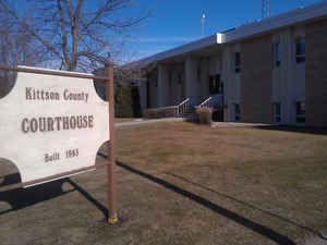
Kittson County is a county located in the state of Minnesota. Based on the 2010 census, the population was 4,552. Its county seat is
Hallock. It is named after Canadian fur trader and railroad entrepreneur Norman Kittson. The county was officially organized on February 25,
1879, having been part of the Pembina District prior to that time. The county also included the western portion of what is now Roseau County
until 1894.
Skull Lake is Kittson County's only natural lake. Lake Bronson, for which the city of Lake Bronson takes its name, is man-made.
Kittson County is south from the Canadian border province of Manitoba.
Etymology - Origin of Kittson County Name
The county is named after Norman W. Kittson, an early fur trader and partner of the American Fur Company, and a member of territorial legislature, 1851-55 and mayor of St. Paul, 1858. . He increased the fur trading traffic significantly by increasing the use of oxcarts. He was also responsible for the pioneering of the steamboat in the Red River and was active with James J. Hill in the development of the railroad. His contributions played an important role in the settlement of the county. The Cathedral of St. Paul is built on the former site of his home
Demographics:
County QuickFacts: CensusBureau Quick Facts
Kittson County History
Pembina County was created on October 27, 1849 (organized in 1852 then deorganized in 1853) from Unorganized Territory. On February 25, 1879 the county name was changed to Kittson County (Organized in 1897). Part of the Pembina District until organization, the county also included the western portion of what is now Roseau County until 1894. The county was named in honor of Norman Kittson (1814-1888), an early fur trader & partner of the American Fur Company. He increased the fur trading traffic significantly by increasing the use of oxcarts. He was also responsible for the pioneering of the steamboat in the Red River and was active with James J. Hill in the development of the railroad. His contributions played an important role in the settlement of the county.
Geography: Land and Water
As reported by the Census Bureau, the county has a total area of 1,104 square miles (2,860 km2), of which 1,099 square miles (2,850 km2)
is land and 4.8 square miles (12 km2) (0.4%) is water.
Kittson County was once part of glacial Lake Agassiz. Evidence of this prehistoric lake can still be seen in the topography of the county
today. Remnants of "McCauleyville Beach" of Lake Agassiz, can be found on the eastern portion of the county. This is an area of sandy soil and
sand ridges. Other evidence of the glacier and Lake Agassiz is the approximately 140' drop in elevation from the eastern portion of the county
to the western part, near the Red River. This is where one can find the black, rich soil that the Red River Valley is famous for.
Neighboring Counties
Bordering counties are as follows:
- Town of Emerson, Manitoba (north)
- Rural Municipality of Franklin, Manitoba (north)
- Rural Municipality of Stuartburn, Manitoba (north)
- Roseau County, Minnesota (east)
- Marshall County, Minnesota (south)
- Walsh County, North Dakota (southwest)
- Pembina County, North Dakota (west)
Education


Click Image to Enlarge
